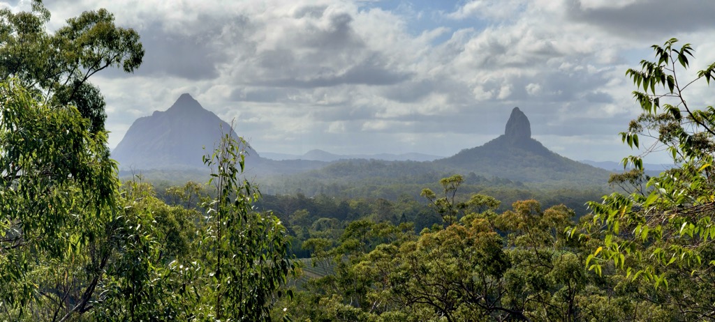
Mount Tibrogargan is a small mountain in the Glass House Mountains National Park, north-northwest of Brisbane, Australia. It is a magma intrusion of hard alkali rhyolite that squeezed up into the vents of an ancient volcano 27 million years ago.
Tibrogargan is one of the most easily recognised hills in South East Queensland, bearing some resemblance to a woman holding a baby looking over her shoulder. However, in 2004 parts of the rock face that resembled eyes eroded and subsequently crumbled off. The name Tibrogargan comes from the local aboriginal words chibur flying squirrel and kaiyathin biting.
In the mythology of the region, Tibrogargan was the father of all the other Glass House Mountains except Beerwah, his wife. It was said that Tibrogargan saw a rising of the waters from the sea, and called to his son Coonowrin to take his mother Beerwah to a safe place; however, Coonowrin (a.k.a. Crookneck) failed to do so, and in anger Tibrogargan clubbed Coonowrin and broke his neck. Tibrogargan is said to have turned his back to face Coonowrin.
Tibrogargan is relatively small compared to mountains in Queensland and elsewhere, standing at 364 metres, but is the third tallest of the Glasshouse Mountains being 192m shorter than the tallest of the group (Mount Beerwah at 556m). The scramble to the summit via the route on the Western side of the mountain is a relatively straightforward one if heights and scrambling up near vertical rock face are not daunting. Climbers do not need technical skills such as abseiling. The mountain is a popular destination for bushwalkers, and tourists. Some visitors have got into difficulty on the hill and have been the subject of rescues by the State Emergency Service and rescue helicopters.
Tibrogargan is also popular amongst rockclimbers, with a number of free climbing routes found on the hill, ranging in grade from beginner to expert, both single and multi pitch traditional and sport climbs. The majority of these are found on the Eastern side of Mt Tibrogargan.
Public access to the tallest and second tallest Glasshouse Mountains reopened at the end of 2015 after being closed from 2009 to 2015 and 1999 respectively. The path is well worn and visible on the SW shoulder but the views from the summit are restricted due to vegetation in comparison to the other nearby rocky peaks.
There are other less demanding walking trails in the immediate surroundings of Tibrogargan, including the Tibrogargan Circuit (3.3 kilometres (2.1 mi)) and the Trachyte Circuit (5.6 kilometres (3.5 mi)). All trails leave from the carpark at the base of Tibrogargan, including the summit climb.
There's a trail called Tibrogargan Summit Trail leading to the summit.
By elevation Mount Tibrogargan is
# 3 out of 14 in Glass House Mountains National Park
By prominence Mount Tibrogargan is
# 2 out of 14 in Glass House Mountains National Park
We use GPS information embedded into the photo when it is available.
3D mountains overlay
Adjust mountain panorama to perfectly match your photos because recorded by camera photo position might be imprecise.
Move tool
Rotate tool
Zoom
More customization
Choose which peak labels should make into the final photo and what photo title should be.
Next
Photo Location
Satellitte
Flat map
Relief map
Latitude
Longitude
Altitude
OR
Latitude
°'''
Longitude
°'''
Apply
Register Peak
Peak Name
Latitude
Longitude
Altitude
Register
Teleport
PeakVisor
This 3D model of Sagarmatha National Park in Nepal was made using the PeakVisor app topographic data. The mobile app features higher precision models worldwide, more topographic details, and works offline. Download PeakVisor maps today.
Download OBJ model
PeakVisor
The download should start shortly. If you find it useful please consider supporting the PeakVisor app.
PeakVisor for iOS and Android
Be a superhero of outdoor navigation with state-of-the-art 3D maps and mountain identification in the palm of your hand!