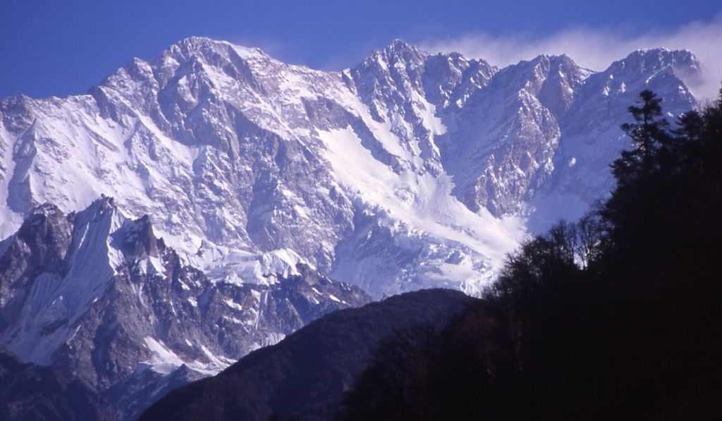
Kangchenjunga, also spelled Kanchenjunga, Kanchanjanghā and Khangchendzonga, is the third-highest mountain in the world. Its summit lies at 8,586 m (28,169 ft) in a section of the Himalayas, the Kangchenjunga Himal, which is bounded in the west by the Tamur River, in the north by the Lhonak River and Jongsang La, and in the east by the Teesta River. It lies in the border region between Koshi Province of Nepal and Sikkim state of India, with the two peaks West and Kangbachen in Nepal's Taplejung District and the other three peaks Main, Central and South directly on the border.
Until 1852, Kangchenjunga was assumed to be the highest mountain in the world, but calculations and measurements by the Great Trigonometrical Survey of India in 1849 showed that Mount Everest, known as Peak XV at the time, is actually higher. After allowing for further verification of all calculations, it was officially announced in 1856 that Kangchenjunga is the third-highest mountain of the world.
The Kangchenjunga is a sacred mountain in Nepal and Sikkim and was first climbed on 25 May 1955 by Joe Brown and George Band, who were part of the 1955 British Kangchenjunga expedition. They stopped just short of the true summit, keeping a promise given to Tashi Namgyal, the Chogyal of the Kingdom of Sikkim, that the top of the mountain would remain inviolate. The Indian side of the mountain is off-limits to climbers. In 2016, the adjoining Khangchendzonga National Park was declared a UNESCO World Heritage Site.
We use GPS information embedded into the photo when it is available.
3D mountains overlay
Adjust mountain panorama to perfectly match your photos because recorded by camera photo position might be imprecise.
Move tool
Rotate tool
Zoom
More customization
Choose which peak labels should make into the final photo and what photo title should be.
Next
Photo Location
Satellitte
Flat map
Relief map
Latitude
Longitude
Altitude
OR
Latitude
°'''
Longitude
°'''
Apply
Register Peak
Peak Name
Latitude
Longitude
Altitude
Register
Teleport
PeakVisor
This 3D model of Sagarmatha National Park in Nepal was made using the PeakVisor app topographic data. The mobile app features higher precision models worldwide, more topographic details, and works offline. Download PeakVisor maps today.
Download OBJ model
PeakVisor
The download should start shortly. If you find it useful please consider supporting the PeakVisor app.
PeakVisor for iOS and Android
Be a superhero of outdoor navigation with state-of-the-art 3D maps and mountain identification in the palm of your hand!