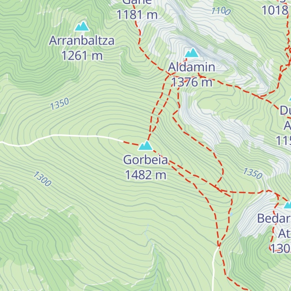
Gorbea (Spanish pronunciation: [goɾˈβea]) or Gorbeia (Basque pronunciation: [gorβei.a]) is a mountain and massif in the Basque Country, Spain. It is the highest summit in Biscay and Álava, with a height of 1,482 metres (4,862 ft) above sea level. The massif covers a wide area between the two provinces. The main summit is a round grass-covered mountain crowned by a 17-metre-tall metallic cross. Historically, it was one of the five montes bocineros of Biscay, from where meetings to the Juntas Generales of the Lordship of Biscay were announced.
To the north of the massif lies the karstic plateau of Itxina, an area full of shafts and caves such as Supelegor. The southern side of the mountain is less craggy, being covered by forests. Other notable mountains of the massif are Berretin to the south and the Lekanda and Aldamin limestone peaks to the north.
Since 1994, the whole massif has been part of the Gorbeia Natural Park, established to preserve the local beech and oak forests as well as the populations of wild boars and deer. Its status as the highest summit in two provinces and easy access have made it one of the most emblematic mountains in the Basque Country.
There's a trail leading to the summit. Gorbeia is one of the 39 peaks along the multi-day GR 12 Euskal Herriko ibilaldia/Sendero de Euskal Herria.
The nearest mountain hut is Egiriñao located 1 263m/4 144ft NNW of the summit.
By elevation Gorbeia is
# 1 out of 1128 in Álava # 1 out of 1258 in Biscay # 9 out of 3254 in Basque Country # 1 out of 126 in Gorbeiako parke naturala/Parque Natural del Gorbea
By prominence Gorbeia is
# 55 out of 81984 in Spain # 1 out of 1128 in Álava # 1 out of 1258 in Biscay # 2 out of 3254 in Basque Country # 1 out of 126 in Gorbeiako parke naturala/Parque Natural del Gorbea # 12 out of 14515 in the Cordillera Cantabrica
We use GPS information embedded into the photo when it is available.
3D mountains overlay
Adjust mountain panorama to perfectly match your photos because recorded by camera photo position might be imprecise.
Move tool
Rotate tool
Zoom
More customization
Choose which peak labels should make into the final photo and what photo title should be.
Next
Photo Location
Satellitte
Flat map
Relief map
Latitude
Longitude
Altitude
OR
Latitude
°'''
Longitude
°'''
Apply
Register Peak
Peak Name
Latitude
Longitude
Altitude
Register
Teleport
PeakVisor
This 3D model of Sagarmatha National Park in Nepal was made using the PeakVisor app topographic data. The mobile app features higher precision models worldwide, more topographic details, and works offline. Download PeakVisor maps today.
Download OBJ model
PeakVisor
The download should start shortly. If you find it useful please consider supporting the PeakVisor app.
PeakVisor for iOS and Android
Be a superhero of outdoor navigation with state-of-the-art 3D maps and mountain identification in the palm of your hand!