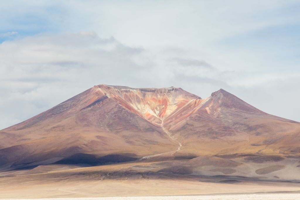
Cerro Ascotan (also known as del Jardin) is a volcano on the border between Chile and Bolivia. It is 5,473 metres (17,956 ft) high, 1,770 metres (5,810 ft) above the terrain and a maximum slope in the summit area of 26°. A breach in the edifice is 1.9 kilometres (1.2 mi) wide and 3.4 kilometres (2.1 mi) long, with an azimuth of 252°. The current snowline lies between 5,700–5,900 metres (18,700–19,400 ft); during the Pleistocene it was lower at 4,900–5,000 metres (16,100–16,400 ft). The volcano's summit, about one third thereof, was removed by a large explosion, with debris thrown at large distances. Volcanic activity probably occurred during the Pleistocene. The volcano is neighbor to Cerro Araral.
By elevation Cerro Ascotán is
# 73 out of 410 in Provincia de El Loa # 78 out of 973 in Región de Antofagasta # 18 out of 232 in Provincia Nor Lípez # 70 out of 1235 in Potosí
By prominence Cerro Ascotán is
# 33 out of 410 in Provincia de El Loa # 42 out of 973 in Región de Antofagasta # 93 out of 3781 in Bolivia # 21 out of 232 in Provincia Nor Lípez # 49 out of 1235 in Potosí
We use GPS information embedded into the photo when it is available.
3D mountains overlay
Adjust mountain panorama to perfectly match your photos because recorded by camera photo position might be imprecise.
Move tool
Rotate tool
Zoom
More customization
Choose which peak labels should make into the final photo and what photo title should be.
Next
Photo Location
Satellitte
Flat map
Relief map
Latitude
Longitude
Altitude
OR
Latitude
°'''
Longitude
°'''
Apply
Register Peak
Peak Name
Latitude
Longitude
Altitude
Register
Teleport
PeakVisor
This 3D model of Sagarmatha National Park in Nepal was made using the PeakVisor app topographic data. The mobile app features higher precision models worldwide, more topographic details, and works offline. Download PeakVisor maps today.
Download OBJ model
PeakVisor
The download should start shortly. If you find it useful please consider supporting the PeakVisor app.
PeakVisor for iOS and Android
Be a superhero of outdoor navigation with state-of-the-art 3D maps and mountain identification in the palm of your hand!