Black Combe is a fell in the south-west corner of the Lake District National Park, England, just 4 miles (6.4 km) from the Irish Sea. It lies near the west coast of Cumbria in the borough of Copeland and more specifically, in the ancient district of Millom. It is 1,970 ft (600 m) high and stands in isolation, some 10 mi (16 km) away from any higher ground; this factor offers an excellent all-round panoramic view of land and sea, weather permitting.
Black Combe is a Marilyn and, at 600m, it is only 10m short of being a Hewitt. Sub-tops include White Combe, Stoupdale Head, Swinside Fell and Stoneside Hill. The first two but not the last two are included in the index of Wainwright's The Outlying Fells of Lakeland and thus in lists of "Outlying fells". (All four sub-tops are shown on Wainwright's map of the fell in that book
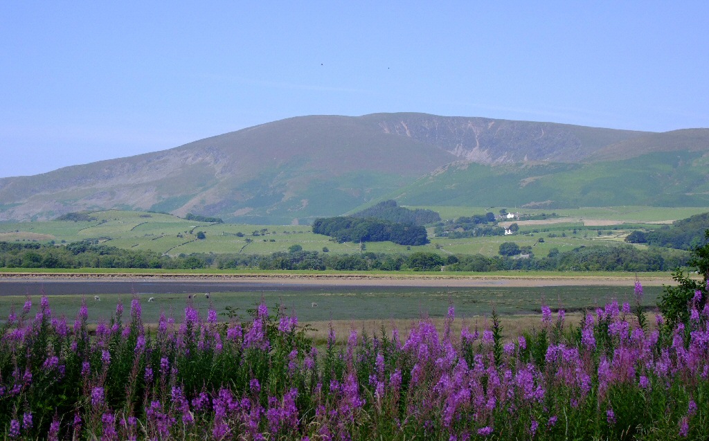
The view from Black Combe is unique, a result of its isolated position to the south and west of the main Lake District fells. William Wordsworth claimed that "the amplest range of unobstructed prospect may be seen that British ground commands." Half the view is the glittering sea, with the Isle of Man seen clearly to the west, and the hills of Wales and Scotland seen as shadowy silhouettes.
On the seaward side views extend from the Cumbrian coast, and from Criffel, 49 mi (79 km) to the north, a mountain on the Scottish coast near Dumfries, round to the Isle of Man, 45 mi (72 km) due west, then round to Snowdon which may be seen on days of exceptionally good visibility, 85 mi (137 km) to the south, to the coast of Lancashire. On the landward side, views include the Scafell Group and the Coniston Group of fells in the Lake District National Park, including four 3,000 ft (910 m) mountains: Skiddaw, Scafell, Scafell Pike and Helvellyn. To the east and south the Pennine Hills, the Forest of Bowland and Blackpool Tower are visible. Closer by, there are also good views over the Duddon Estuary, Millom and the wind farm just offshore.
Black Combe is easy to see across Morecambe Bay as the most westerly outlying fell of the Lake District National Park. The name of the Cumberland View public house in Morecambe reflects the fact that Black Combe used to stand in the historical county of Cumberland. It can also be seen from the top end of the Wirral peninsula, between the turbines of the new Burbo Bank Offshore Wind Farm.
Clearly visible in views of Black Combe from the south and east is the large, dark-coloured glacial corrie, known as Blackcombe, from which the fell's name is derived. Such corries are often known as combes in English place names, a word cognate with the Welsh word cwm. Adjacent to Blackcombe is a lighter-coloured corrie called Whitecombe.
Black Combe was one of the five stations in Cumberland used by the Ordnance Survey to measure the angles of Principal Triangles for their initial survey of Britain in the years up to and including 1809. The other stations were "Dent Hill", Scilly Banks (on the outskirts of Whitehaven), High Pike and Cross Fell.
The Black Combe Walking Festival takes place annually in June and the Black Combe fell race takes place in early March.
The Swinside, or Sunken Kirk, stone circle is on the eastern flanks of Swinside Fell, in the north east of Black Combe.
There's a trail leading to the summit.
By prominence Black Combe is
# 23 out of 12948 in the England Hills # 11 out of 864 in Lake District National Park # 23 out of 13057 in England # 14 out of 1704 in Cumbria # 11 out of 838 in The English Lake District WHS
We use GPS information embedded into the photo when it is available.
3D mountains overlay
Adjust mountain panorama to perfectly match your photos because recorded by camera photo position might be imprecise.
Move tool
Rotate tool
Zoom
More customization
Choose which peak labels should make into the final photo and what photo title should be.
Next
Photo Location
Satellitte
Flat map
Relief map
Latitude
Longitude
Altitude
OR
Latitude
°'''
Longitude
°'''
Apply
Register Peak
Peak Name
Latitude
Longitude
Altitude
Register
Teleport
PeakVisor
This 3D model of Sagarmatha National Park in Nepal was made using the PeakVisor app topographic data. The mobile app features higher precision models worldwide, more topographic details, and works offline. Download PeakVisor maps today.
Download OBJ model
PeakVisor
The download should start shortly. If you find it useful please consider supporting the PeakVisor app.
PeakVisor for iOS and Android
Be a superhero of outdoor navigation with state-of-the-art 3D maps and mountain identification in the palm of your hand!