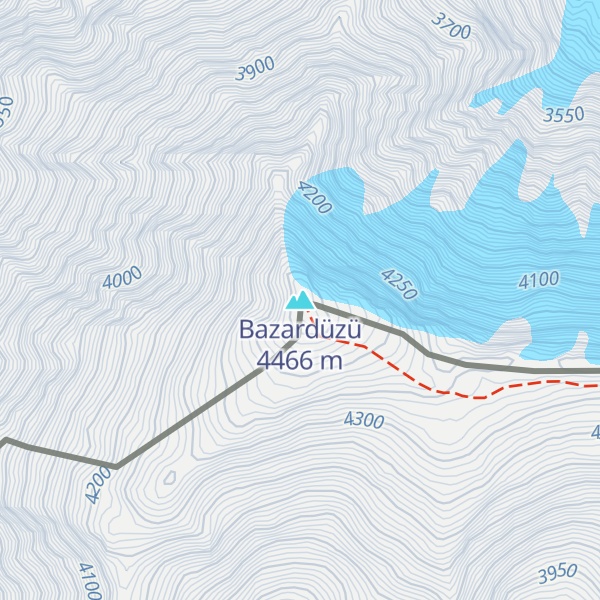
Mount Bazardüzü (Azerbaijani: Bazardüzü dağı, Azerbaijani pronunciation: [bɑzɑrdyˈzy]; Lezgian: Кичӏен сув [kiˈtʃʼe suv]; Russian: Базардюзю, Russian pronunciation: [bəzərdʲʉˈzʲu]) is a mountain peak in the Greater Caucasus range on the border between Russia (Dagestan) and Azerbaijan. At 4,466 metres (14,652 ft) above sea level, it is the highest peak in both Dagestan and Azerbaijan, and is located in the Qusar region. The southernmost point of Dagestan (and therefore Russia) is located about seven kilometers southwest of the peak. Translated from Azerbaijani, Bazarduzu means “market square”, more precisely as a specific landmark - “turn to the market, bazaar”. In the Middle Ages in the Shahnabad Valley, located east of this peak, annual large multinational fairs were held.
There's a trail called Camp2 - Bazarduzu leading to the summit.
By elevation Bazardüzü is
# 1 out of 755 in Republic of Dagestan # 1 out of 11 in Dokuzparinsky District # 1 out of 1496 in Azerbaijan # 1 out of 21 in Qusar District # 54 out of 24823 in Russia # 56 out of 4326 in the Greater Caucasus # 56 out of 7939 in the Caucasus
By prominence Bazardüzü is
# 1 out of 755 in Republic of Dagestan # 1 out of 11 in Dokuzparinsky District # 1 out of 1496 in Azerbaijan # 1 out of 21 in Qusar District # 8 out of 24823 in Russia # 2 out of 4326 in the Greater Caucasus # 2 out of 7939 in the Caucasus
We use GPS information embedded into the photo when it is available.
3D mountains overlay
Adjust mountain panorama to perfectly match your photos because recorded by camera photo position might be imprecise.
Move tool
Rotate tool
Zoom
More customization
Choose which peak labels should make into the final photo and what photo title should be.
Next
Photo Location
Satellitte
Flat map
Relief map
Latitude
Longitude
Altitude
OR
Latitude
°'''
Longitude
°'''
Apply
Register Peak
Peak Name
Latitude
Longitude
Altitude
Register
Teleport
PeakVisor
This 3D model of Sagarmatha National Park in Nepal was made using the PeakVisor app topographic data. The mobile app features higher precision models worldwide, more topographic details, and works offline. Download PeakVisor maps today.
Download OBJ model
PeakVisor
The download should start shortly. If you find it useful please consider supporting the PeakVisor app.
PeakVisor for iOS and Android
Be a superhero of outdoor navigation with state-of-the-art 3D maps and mountain identification in the palm of your hand!