
Scan the QR code and open PeakVisor on your phone
Talampaya National Park is a UNESCO World Heritage Site in La Rioja, Argentina. Among the incredible landscape are important archeological and paleontological sites that give insight into the formation of the world and its past inhabitants.
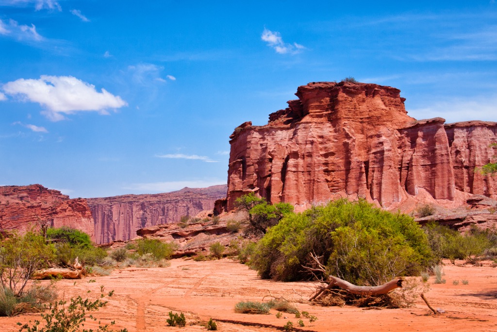
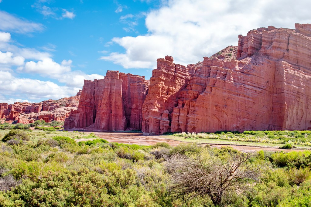
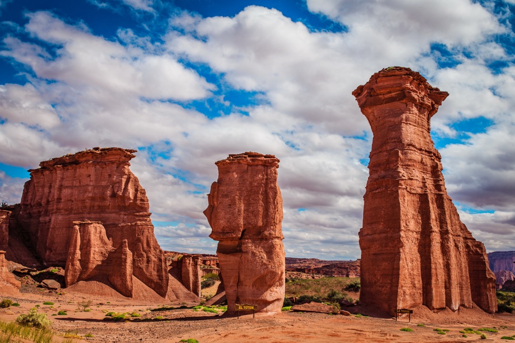
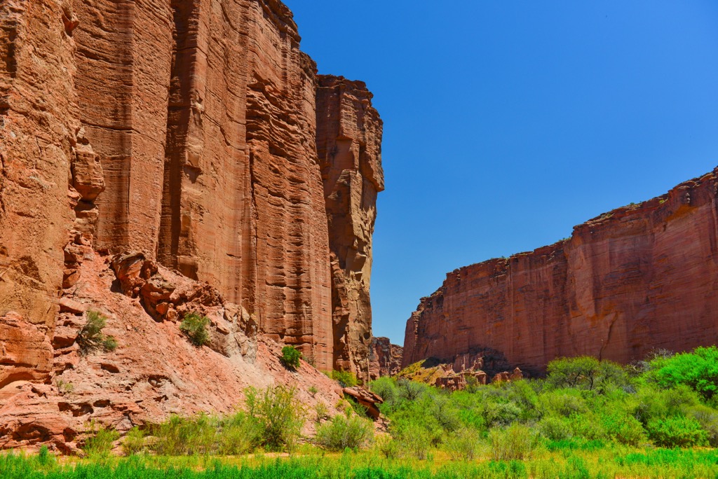
Many of the peaks are incredible sandstone structures through which the rains have eroded steep canyons. Cerro Tarjado is the tallest of the park’s twelve peaks, with an elevation of 2,065 m (6,775 ft) and Cerro Rajado (1,866 m/6,122 ft) is the most prominent of the peak with 617 m (2,024 ft) of prominence.
Situated along the western border of La Rioja, Argentina, Talampaya National Park covers 2,150 square kilometers (830 sq mi) of a stunning landscape. The park is known for its steep sided mountains, incredible canyons, and archeological and paleontological sites.
There are twelve named peaks in the park, of which Cerro Tarjado (2,065 m/6,775 ft) is the tallest and Cerro Rajado (1,866 m/6,122 ft) is the most prominent. The wind and rain have carved the mountains and canyons of the park into stunning formations that are a delight to visit.
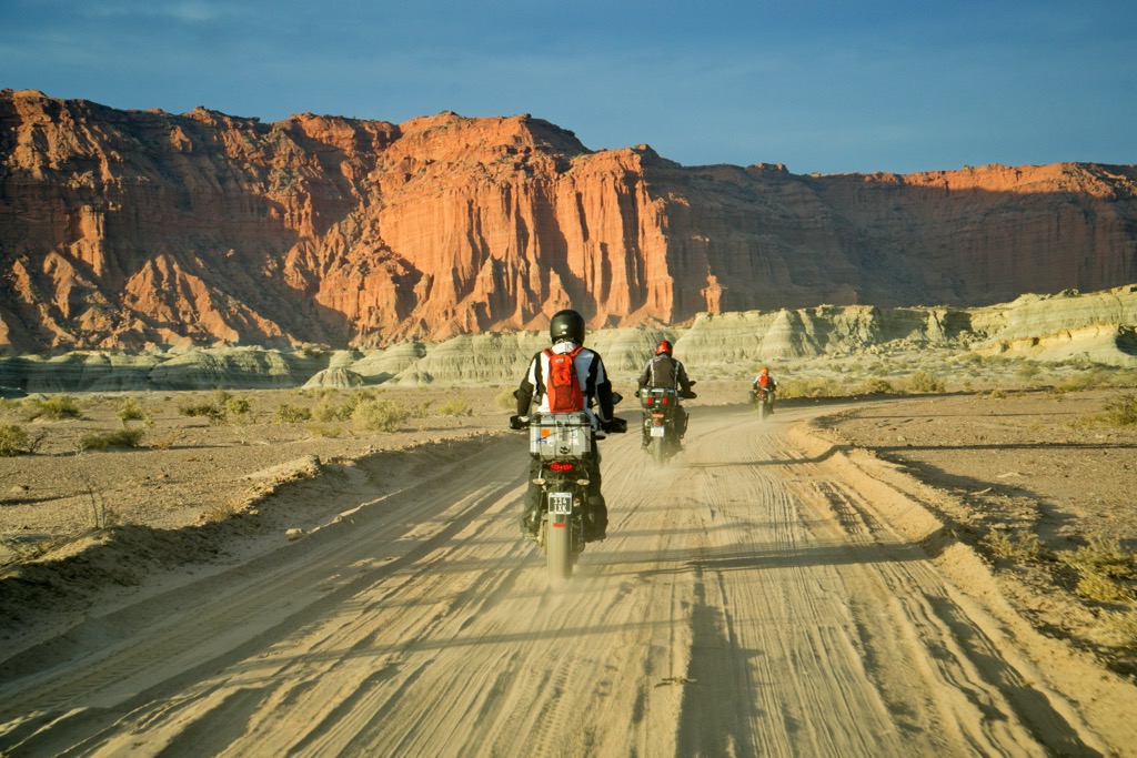
The park is centered along the Talampaya River where dinosaurs roamed during the Triassic. Highway 76 passes through the center of the park; however, only about 5% of the park is easily accessible. The park is in the valley between Cerro Los Colorados to the west and Sierra de Sañagasta to the east.
The park is located in the High Monte ecoregion of Argentina and many parts of the park are only accessible with a guided tour, to help preserve the delicate ecosystem, natural features, and other historical resources. The park contains petroglyphs, a botanical reserve, and stunning geological formations carved into the red sandstone.
Talampaya National Park is adjacent to Ischigualasto Provincial Park, in the province of San Juan. Other nearby parks and protected areas include:
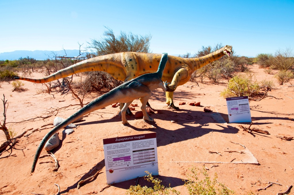
The area was first established as a provincial park in 1975 and then a national park in 1997. Along with Ischigualasto Provincial Park, Talampaya National Park became a UNESCO World Heritage Site in 2000 containing the most complete continental fossil record known from the Triassic.
Talampaya National Park is located along the eastern edge of the Andes Mountains is a basin that has existed since the Triassic. The basin is known geologically as the Ischigualasto-Villa Unión Basin, it was one of several rift basins that developed along the west side of Pangea during the Late Permian and Early Triassic.
As Pangea was breaking apart, rift basins formed and were consequently filled over the following millions of years. In the case of the Ischigualasto-Villa Unión Basin where Talampaya National Park is, the basin filled with layers of sand which was compressed into sandstone.
Upon the bedrock, the first layers are the red sandstone Talampaya and Tarjados formations which were generally deposited by water flowing into the basin from the continent. Braided rivers were common across the basin during the Triassic and their regular flooding brought more layers to create the incredible fossil record of the Triassic.
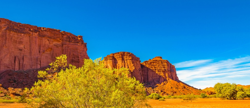
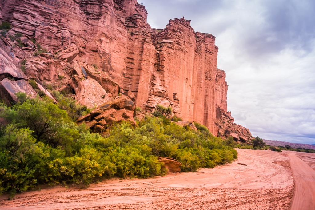
The low mountains of the park show the erosive power of wind and water. The straight canyons and high walls are testament to torrential summer rains and strong spring winds upon the arid landscape.
Over millions of years the wind shaped rocks into different formations, many of which have been named. Some of the rock formations are the Friar, the Wizard King, the Cathedral, the Chess Board, the Needles, the Manger and the Castle.
While relatively low compared to the heights of the Andes Mountains, Talampaya National Park, and most of La Rioja is part of the High Mountain ecosection. The flora and fauna found in the park is typical to the region and are adapted to the high elevation and arid climate.
Most of the vegetation are the low shrubs such as jarillas, wild cane, and broom plants that have few leaves and carry out most of their photosynthesis through its stem. There are cacti such as puquis and various cardones, and you’re likely to see chilca, which is a mountain shrub endemic to La Rioja, San Juan, and San Luis.
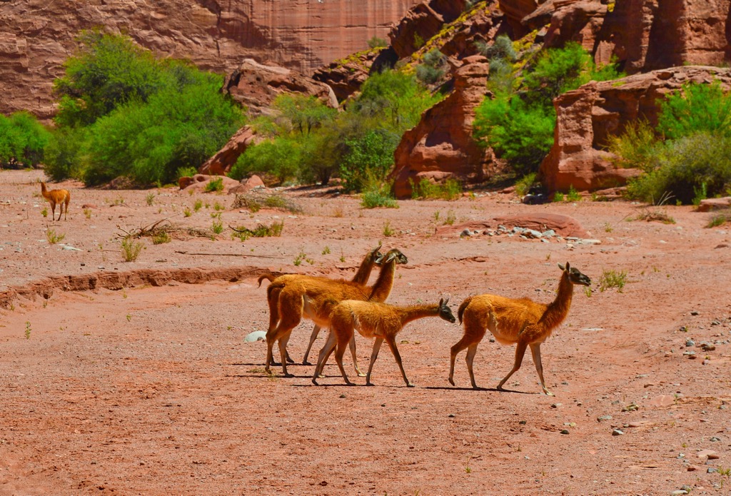
There are 120 species of fauna that have been documented as inhabiting the national park. Gray foxes, black-footed squirrels, and black larks inhabit areas near the entrance to the park and are among the first visitors might notice. The Andean condor, Moorish eagle, and the peregrine falcon post upon the cliffs with an eye searching for prey, such as the chinchillón.
Other animals which you may see are the sand cock, the reddish canastero, and the brown cacholote which are all endemic to Argentina. You may also be lucky enough to notice a pichiciego, which is a small burrowing armadillo. Guanacos, Andean suris, quirquinchos, hares , vicuñas , pumas , maras , red foxes, and reptiles such as pythons and rabbit vipers also inhabit the national park.
In prehistoric times, Talampaya National Park was used by several indigenous groups of semi-nomadic hunters and gatherers. Archeological evidence suggests that from about 600 BCE to 1000 CE, the park was inhabited by the primitive La Fortuna and Aguada cultures.
Before the Spanish conquest, Incan influence arrived in the area, where at the time members of the Huarpes and Diaguita were living. After 1600, Spanish colonization was pressing upon the region from Chile, in the west.
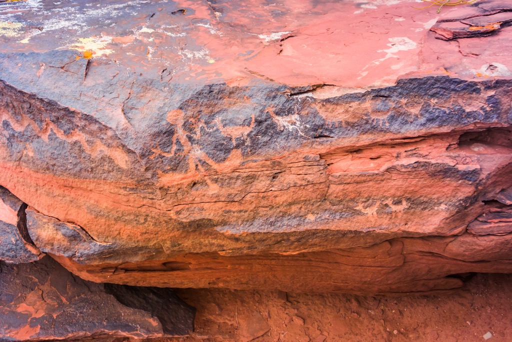
Across the park are sites of rock art, petroglyphs, camp sites, caves, and rock shelters which have been discovered in the parks. These sites give insight into the pre-Columbian inhabitants of the region and how they mastered living in the difficult climate and terrain. The Diaguita in particular are known for having mastered pottery making and they created many artistic pieces.
In general, Jesuit missions arrived in the area in the 1700’s and permanent settlements began to abound along the rivers and where natural springs were discovered. There are no communities in Talampaya National Park; however, Cattle ranching was one of the major activities to occur in and around the area and it still presses at the borders of the park.
Throughout the last half of the nineteenth century cattle were driven through Talampaya on their way over the Andes. Thousands of heads of cattle were driven from central Argentina to the foothills of the Andes in Talampaya where they wintered.
In the spring the cattle were delivered to the mines to provide food for the miners. There is evidence of camps and temporary shelters that attest to the cattle drives as well as artifacts from the period.
It was in 1893 that geologist, Alfrid Stasmed discovered an incredible fossil record of the Triassic in the Talampaya Fields. While there were some discoveries in the region during the first half of the twentieth century, the area remained isolated and remote until the highway was constructed in the 1970s.
During the 1970s, provincial universities began extensive fieldwork which ultimately revealed one of the finest geological finds in the world. The Ischigualasto-Villa Union Triassic Basin contains an exceptionally complete record and sequence of plant and animal life during the Triassic, 250 to 200 million years ago.
Talampaya Provincial Park was established in 1975 and it was upgraded to a national park in 1997. In 2000, Talampaya was recognized as a UNESCO World Heritage Site along with the adjacent Ischigualasto Provincial Park.
Massive sandstone cliffs, stunning rock formations, incredible paleontological and archeological discoveries, and unique flora and fauna are awaiting visitors to Talampaya National Park. The following are some of the tours and attractions in Talampaya National Park.
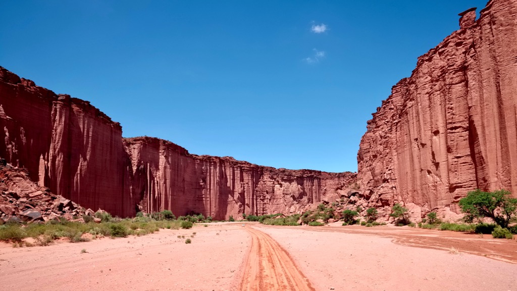
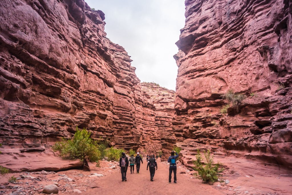
Touring Talampaya National Park is only permitted as part of a guided tour which can be booked at the visitor center. Talampaya Canyon is one of the most popular destinations for visitors. The tour features a ride through the canyon, which is quite narrow in spots and the red-sandstone cliffs rise all around you.
There are many incredible rock formations to admire while on the tour as well as the local flora and fauna. The tour through the canyon allows for short excursions to see some of the other features in the area.
One of the typical stops for the tours through Talampaya Canyon is at a location called the Botanical Garden. Here visitors can appreciate the shrub steppe ecosystem and admire the jarillas, as well as a variety of cacti, and retama bushes, carob trees, chañar trees, and brea which has a green bark.
Rising up the cliff adjacent to the garden is a formation called The Chimney. Created from water erosion, this cylindrical groove is neat to see and it produces a remarkable echo effect.
The park is full of rock formations that were sculpted by water and the arid winds of the park over millions of years. Some of the names evoke fantastical imagery while other names are more mundane. Regardless, it is quite an experience to view the Cathedral or the Wizard King. There are also the Tower, Totem, Bottle, Monk, and the Turtle.
There are special tours and presentations that can be booked at the visitor center. Through these tours visitors can be guided through the history of the Triassic upon the Triassic Trail or taken to view some of the petroglyphs of the park. Guided hiking tours to places like Quebrada de Don Eduardo let visitors access spectacular viewpoints while learning about the wildlife, plants, history, and challenges of the area from a local guide.
Located along the remote western border of La Rioja, Talampaya National Park is an incredible place to visit. The construction of the highway between Villa Union and Patquía in the 1970s has given us access to the incredible landscape and history of the region. The following are the major cities of the province and communities closest to the park.
Located over 200 km (120 mi) from Talampaya National Park, the city of La Rioja is the capital of the province of La Rioja. Originally founded in 1591 as an administrative center for the mines in the region as well as a stronghold to fight against the local indigenous groups.
The city sustained serious damage in an earthquake in the 1890s, after which the city was reconstructed in more modern terms. A rich history and culture as well as incredible people make La Rioja a wonderful place to visit.
There are wonderful local attractions for visitors, such as walks through the city focused on the history or the churches. There are also wonderful areas just outside the city, such as Dique Los Sauces where visitors can hike, fish, swim, and camp in an area with abundant references to the history of the region.
Further abroad from the provincial capital are the amazing Talampaya National Park or the Reserva Provincial Laguna Brava. Situated along the eastern front of the Andes, La Rioja is an amazing place to visit.
Located about 60 km (36 mi) from Talampaya National Park, Villa Union is a beautiful town situated in the foothills of the Andes. The town is in the heart of the Bermejo Valley amidst the stunning mountains of Sierra de Famatina and Sierra de Maiz.
The area was originally inhabited by Diaguita when the Spanish came in 1634 and settlers arrived in the eighteenth century to establish Los Hornillos, which would later become Villa Union.
There are some interesting local attractions in and around Villa Union. Some of the natural attractions are The Viewpoint which overlooks the town, and Banda Florida and Anchumbil. Banda Florida and Anchumbil contain stunning rock formations and ancient petroglyphs.
Some of the nearby areas that are worth visiting from Villa Union are Talampaya National Park, Reserva Provincial Laguna Brava, Parque Natural Provincial El Chiflón, and Ischigualasto Provincial Park. While Villa Union is easily viewed by foot, a taxi can be an economical way to visit the parks outside of town.
Highway 76 which runs through Talampaya National Park was constructed to connect Villa Union and Patquía. The town of Patquía is about 150 km (90 mi) from Talampaya National Park and it is part of the Pacific to Atlantic, transnational Paso de Agua Negra.
The Paso de Aqua Negra connects the ports of Coquimbo, Chile with Porto Alegre, Brazil through a tunnel in the Andes. Patquía was founded in the late nineteenth century and the name comes from a Quechua expression that means “separation of roads”, or “crossroads”.
Talampaya National Park and Ischigualasto Provincial Park are relatively close to Patquía and are part of the Ischigualasto-Villa Union Triassic Basin and a UNESCO World Heritage Site.


