
Scan the QR code and open PeakVisor on your phone
Datunshan Lianfeng Special Scenic Area has 16 named peaks. The highest is Mt. Datun at 1,092 m. Other notable peaks include Mt. Datun West Peak, Mt. Miantian and Mt. Datun South Peak.
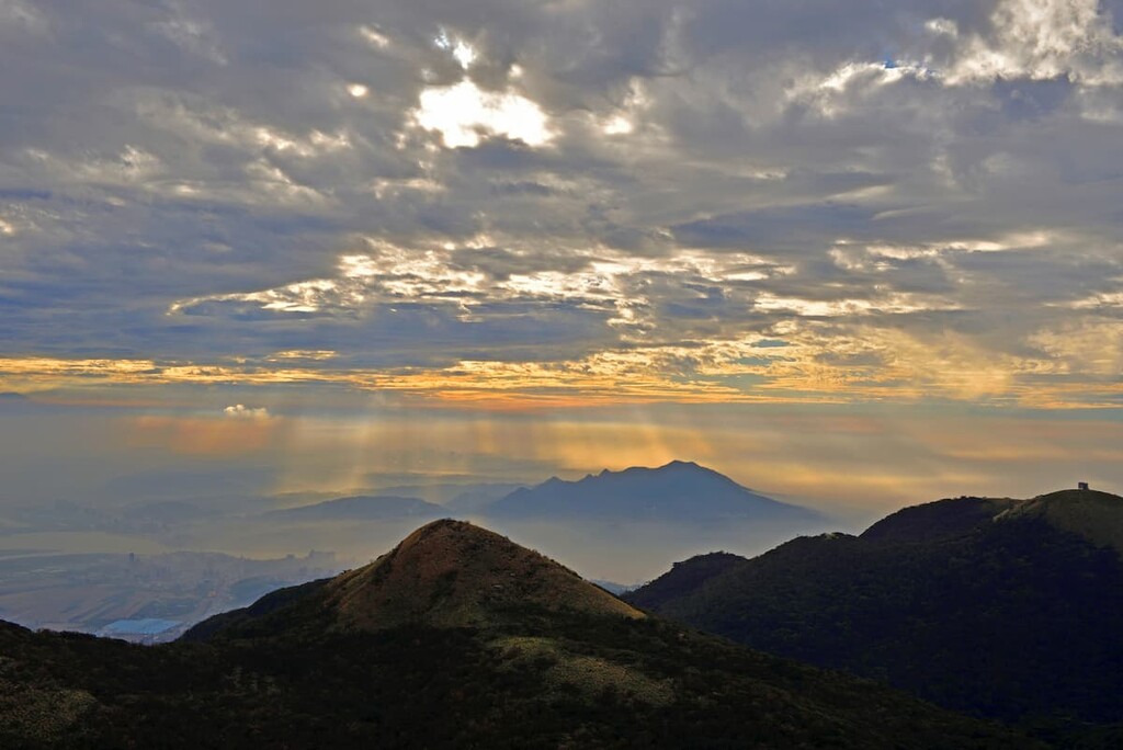
Datunshan Lianfeng Special Scenic Area is home to volcanoes, gentle low-lying valleys, lily fields and a flurry of butterflies. It contains 16 named mountains, of which Datunshan Main Peak (大屯山) is the highest and most prominent at 1,092 metres (3,583 ft).
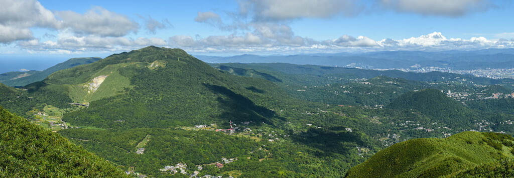
Datunshan Lianfeng Special Scenic Area (大屯連峰自然文化景觀核心特別景觀區) is named after the dormant volcanic mountain of Datunshan (大屯山). It is located in the western area of Yangmingshan National Park (陽明山國家公園), which is situated just north of the capital, Taipei City (臺北市) in northern Taiwan.
Datunshan Lianfeng Special Scenic Area is located just outside the northern Beitou district (北投區) of Taipei City (臺北市) and the Tamsui (淡水區) and Sanzhi (三芝區) districts of New Taipei City (新北市). Datunshan is composed of four peaks: Datunshan Main Peak (大屯山), Datunshan West Peak (大屯山西峰), Datunshan South Peak (大屯山南峰), and Datunshan Southwest Peak ((大屯山西南峰).
The peak of Datunshan is the focal feature of this area; however, many other attractions compete with the mountain’s iconic hiking route.
For example, the meadowed lily valley of Zhuzihu (竹子湖) is located to the east of Datunshan, while the open grassland of Erziping (二子坪) is situated to the northeast of Datunshan’s foothills. The florally fragrant Datun Nature Park (大屯國立公園) is also located just to the north of Datunshan, and the crater pond found below the summit of Xiangtianshan (向天山) is found in the west.
Honglushan (烘爐山) is the northernmost mountain in the Datunshan Lianfeng Special Scenic Area, with Xiangtainchishan (向天池山) extending towards the western border and Zhongzhengshan (中正山)straddling the southern border. Meanwhile, the easternmost peak in the Datunshan area is Dinghushan (頂湖山).
Other notable mountains in the Datunshan area are Miantianshan (面天山), Xiangtianshan (向天山), and Caigongkengshan (菜公坑山).
Areas of interest that fall beyond the boundaries of the Datunshan Lianfeng Special Scenic Area are Qixingshan (七星山) to the east, Beitou Hot Springs (北投溫泉) to the south, Tamsui River (淡水河) to the west, and Baisha Bay (白沙灣) to the north.
Volcanic activity is responsible for the formation of Datunshan and its surrounding peaks. Taiwan is part of the ‘Pacific Ring of Fire,’ where the Earth’s tectonic plates are particularly active. Thus, these constantly shifting tectonic plates formed the mountainous land of Taiwan, and, in particular, the volcanoes in the northern part of the island near Datunshan.
The Datunshan Volcano Group (大屯火山群) is a band of volcanoes that erupted between 200,000 to 1 million years ago. Datunshan is believed to have formed some 500,00 years ago. From the stratigraphic analysis of pyroclastic rock of the Datunshan Volcano Group, studies have found that there were approximately seven stages of eruptions.
The volcanoes belonging to Datunshan Volcano Group represent composite volcanoes, also known as stratovolcanoes, which are composed of an accumulation of lava flows and pyroclastic rock. Andesite and basaltic rock are present in the region.
Within the scenic area, there are also a number of volcanic craters. These craters are hollowed basins below peaks that formed from lava channels erupting from the volcano.
Xiangtian Pond, on the ridge of Xiangtianshan, is an example of a crater lake, and it is situated some 600 meters (1,969 ft) below the peak. However, due to porous soil below the lake, the water does not stay in the lake for an extended period of time before draining into the ground. Thus, Xiangtian Pond springs to life only after a torrential rain.
Plant communities in Datunshan Lianfeng Special Scenic Area include both terrestrial and aquatic ecosystems.
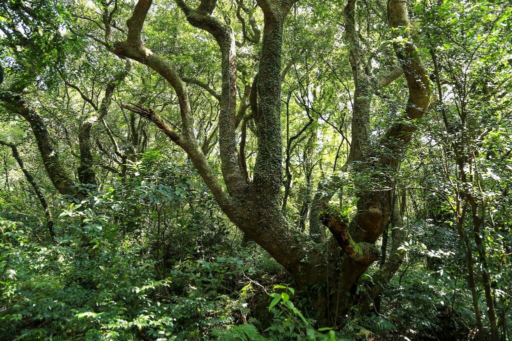
Terrestrial plant communities in the region range from grassy valleys, a bamboo forest brimming with Pseudosasa usawai, temperate evergreen broadleaf forest, and afforestation zones.
The diverse plant life in the Datunshan area is due to the heavily acidic soil caused by volcanic activity and the influence of the mighty northeast monsoon wind in winter that carries torrential rain and bitterly cold temperatures.
Silvergrass dominates the mountainous peaks of Datunshan Main Peak, Datunshan South Peak, Miantianshan, and Xiangtianshan. As the northeastern winds decelerate the process of plant succession, silvergrass is the only plant that survives on exposed mountain peaks. Pseudosasa usawai grows in the sheltered regions along the ridgelines of Datunshan above 800 meters (2,625 ft) in elevation.
At medium elevations on Datunshan South Peak and Datunshan West Peak, a forest of Japanese cedar stands from reforestation efforts in the Datunshan area. Datunshan was once a logging area during the early Japanese Occupation Era; however, Japanese forestry officials implemented reforestation to preserve the forest and planted Japanese black pine, Luchu pine, and Japanese cedar.
A total of 1,360 species of vascular plants live in the Datunshan region, ranging from red nanmu, Formosan sweet gum, Taiwan cherry, Mori cleyera, and Machilus thunbergii.
Aquatic ponds are found in crater marshes and ponds, such as Xiangtian Pond, Erziping, and Datun Pond. An array of aquatic species, such as Chinese water chestnut, Japanese spikerush, rough-seed bulrush, and pipewort, are found in the waters of these crater ponds.
Nectar plants, such as Chinese angelica, Eupartirum shimadai, and China elder, are scattered along the trail of Datunshan, which attracts a flurry of honeybees and butterflies in the summer months. In fact, Datshun is a superb place to witness the 168 species of butterfly flutter around the landscape.
Gossamer-winged butterflies, chestnut tigers, and striped-blue crow butterflies are some of the more frequent butterflies.
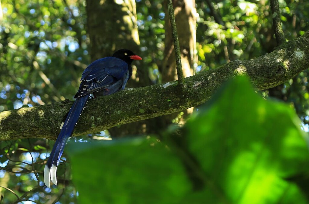
Datunshan is also a fine spot to observe the 122 species of birds that frequent the area.
In the densely forested region of Datun Nature Park, the bamboo partridge, Japanese white-eye, black bulbul, and red-headed babbler are primarily present, while in the grassy plains, white-rumped munia, yellow-bellied Prinia and vinous-throated parrotbill feature. The Formosan whistling thrush, grey wagtail, and little egret occupy the aquatic areas of Datunshan.
Datunshan was once known as Caoshan, which translates as ‘Grass Mountain.’ Datunshan Lianfeng Special Scenic Area was a hotspot for thieves stealing the sulphur deposits in the area, so government officials would set fire to the mountain to deter thieves from trespassing onto the site.

As a result of the fires, the vegetation in the region was decimated, and only grass could be seen along the whole area of Datunshan, giving it the name Grass Mountain.
In the late Qing Dynasty and early Japanese Occupation Era, the Datunshan area was a popular logging spot; however, in 1913, the Japanese halted logging operations and established protected forest areas to maintain the landscape and water of Datunshan. Large-scale reforestation began in 1924 with the planting of Japanese cedar, Japanese black pine, and Luchu pine.
During reforestation, hiking trails along the ridgelines were established, which once served as firebreaks. In total, there were 15 fire breaks, each of which was 1 metre (3 ft) long and 6 to 7 metres (20 to 23 ft) wide. There were also guard huts planted at the end of the fire break passage.
In 1937, the Japanese established Daiton National Park, which included Datunshan, Qixingshan, and Guanyinshan. This area was rezoned in 1963 to include the northern regions of Jinshan and Sanzhi districts of New Taipei City. Yangmingshan National Park was founded on 16 September 1985 and it includes the area of Datunshan.
Datunshan Lianfeng Special Scenic Area includes hilly mountain climbs of wavering difficulty and leisurely trails along picturesque valleys. Here are some of the best climbs to check out during your visit:
The 5.4 km (3.4 mi) trail stretches across the Datun Range from north to southwest, summiting Datunshan Main Peak, Datunshan South Peak, and Datunshan West Peak.
This hike can start at either of two trailheads, Qingtian Temple Trailhead or Bailaka Trailhead. But, most hikers opt to commence their journey from the latter trailhead as it is just under a 1 km (0.6 mi) trek from there to Datunshun Main Peak.
The climb from Bailaka Trailhead to Datunshan Main Peak is a moderately challenging climb, with gentle gradients in some parts and steeper inclines in others. Hikers are first met with a prevalence of bamboo in the early parts of the trail, but the wispy silvergrass near the mountains’ summits sits in stark contrast to the ecosystems that are located at lower elevations in the region.
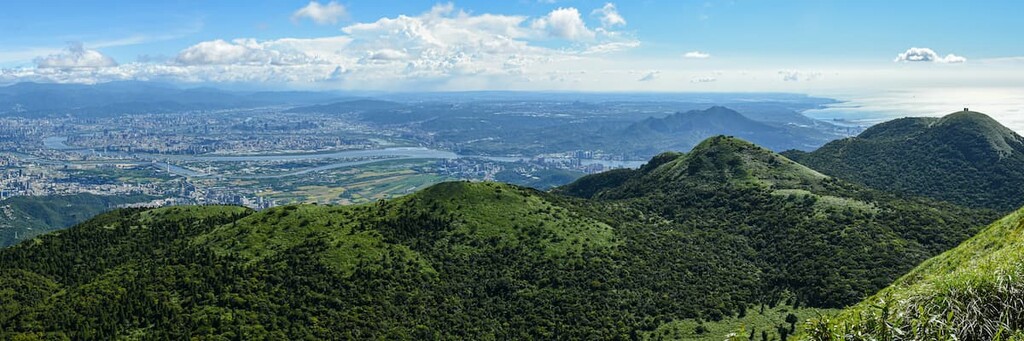
At 1,092 metres (3,583 ft) in elevation, hikers are greeted with a panoramic view of Taipei and the nearby mountains once they reach the summit of Datunshan Main Peak. From this view, Qixingshan is located to the east and Miantianshan in the north. Additionally, the lower Datunshan South and West Peaks can be viewed from above, while hikers can locate the Tamsui River flowing in the east.
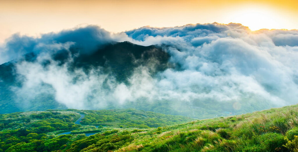
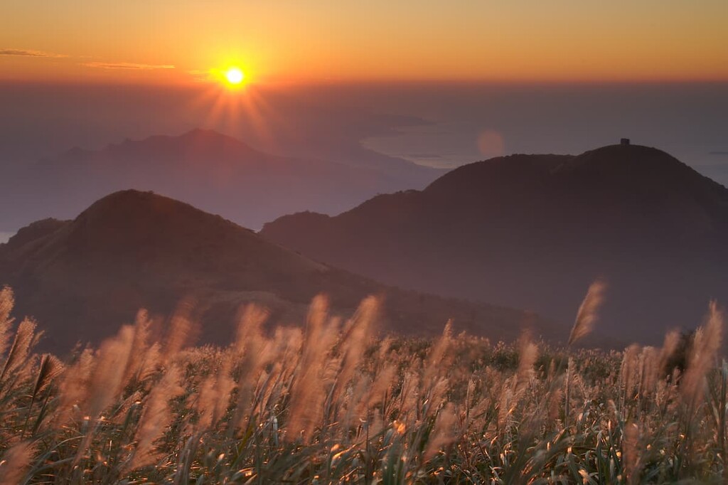
The summit of Datunshan is well-known as a fantastic spot to witness the iconic Datun sunset and the region’s beautiful clouds. Datunshan is also famed for its large butterfly population in the summer months. You can also hear a chorus of grass cicadas merrily chirp along the silvergrass lawn sweeping the mountain floor.
Hikers can either descend the mountain returning to the Bailaka Trailhead or continue the path towards the other two Datun peaks. The trail's difficulty becomes increasingly challenging as hikers head forth towards Datun South Peak and Datun West Peak, as it is a sharp drop past Datunshan Main Peak.
At this point, the stone covered trail is replaced with bare ground, and if it has been raining, a muddy mess. For this reason, rope barriers are erected along the path to aid with balance and stability. After a series of muddy, rocky scrambles, Datunshan South Peak is reached some 900 metres (2,953 ft) later, while Datunshan West Peak is a further 600-metre (1,969 ft) steep descent.
From Datunshan West Peak, a considerably steep trail leads hikers towards the Erziping area, or hikers can continue the path towards Sansheng Temple and culminate at the trailhead of Qingtian Temple, a mere 400 metres (1,312 ft) away.
The area of Erziping (二子坪) is located in the saddle between Datunshan Main Peak and Erzishan (二子山).
There is a shorter trail of 1.8 km (1.1 mi) along the Erziping Area; however, the entire trail is about 4.4 km (2.7 mi) long. The trail takes visitors past the peaceful grassland of Erziping, the ecological pond, and then sweeps past Qingtian Temple before ending in Beitou, to the south of the Datunshan Lianfeng Special Scenic Area.
The highlight of Erziping Trail is its open meadows, which are a perfect spot for picnicking as they allow people of all ages to enjoy the serene landscape. The flat paved trail is fairly casual and it allows visitors to slow down and enjoy the beautiful environment, which includes several small ponds that are set against a backdrop of dramatic mountains.
As the Erziping Trail is located in a valley, it is often cloaked in mist, giving an ethereal feel to the lush, emerald landscape.
Due to its location at the foothill of Datunshan Main Peak, which is known for being a magnet for butterflies, a flurry of butterflies sweep through the valley of Erziping, where nectar-bearing plants like green maple flourish.
The phenomenal orange oak leaf butterfly is an amusing sighting in this area, as it visually mimics dry orange leaves in order to camouflage itself against predators. The Taipei green frog can be seen and heard along this area as a melody of croaks erupt around the several ponds.
The challenging 4.2 km (2.6 mi) Miantianshan Trail summits two mountains, Miantianshan and Xiangtianshan, and is known for its sharp gradient. Miantianshan is a parasitic volcano cone that extends outward from the flanks of Datunshan.
The Miantianshan Trailhead is situated in the Erziping area. After a 1.7 km (1 mi) incredibly tough climb along a mossy cobblestone shaded path, an ocean of silvergrass signals the upcoming summit of Miantianshan at 979 metres (3,212 ft).
From the summit, hikers can witness 270-degree vistas of the peaks of Guanyinshan and Yuanshan in New Taipei City. However, the Datun peaks block the view of the mountains behind them, so the vistas aren’t quite panoramic. Toward the north, views of coastal plains dotted with farms and graveyards can also be seen.
Xiangtianshan is a short walk from Miantianshan, which offers the same views at a lower elevation; however, the main attraction of Xiangtianshan is the 100-metre (328 ft) wide crater lake of Xiangtian Pond, which is located some 600 metres (1,969 ft) below the summit. Here, a pine forest replaces the dominant silvergrass as hikers descend towards Xiangtain Pond, which is home to two kinds of shrimp: clam shrimp and fairy shrimp.
Xiangtian Pond is more dramatic after heavy rains as the pond reaches its full potential with a depth of about 5 metres (16 ft). As the soil is absorbent here, the pond water can seep through the ground, thus shrinking its overall size and depth. Hikers can view some aquatic common rush plants while skirting along the pond.
Afterward, hikers will descend the trail back towards the Erziping area to the Xingfuliao Zhengsheng Temple Trailhead. You’ll then pass through a blow-pipe bamboo forest at the lower altitudes of Xiangtianshan before ending your journey.
Situated to the south of Datunshan, the 4km (2.5 mi) Zhongzhengshan trail begins with a steep stone stairway that leads to Zhongzhengshan. Along the climb, hikers are afforded grand views overlooking Beitou and Keelung River.

In the spring, over 100 species of butterflies glide their way around the nectar-bearing plants of golden acacias, azaleas, and Taiwan cherry.
From the summit of Zhongzhengshan at 676 metres (2,218 ft) in elevation, hikers can distinguish the chine line and peaks of Qixingshan and Shamaoshan in the distance. At the same time, hikers can observe the entire basin of Taipei from the southernmost mountain in Datunshan Lianfeng Special Scenic Area.
One of the highlights of this trail is the abundance of plant life on the mountain. For example, fragrant maple dominates the forest area of Zhongzhengshan with its palm-shaped leaves. Meanwhile, Tiber lyonia, a popular ingredient in Chinese medicine, grows in mid to high altitudes on the mountain.
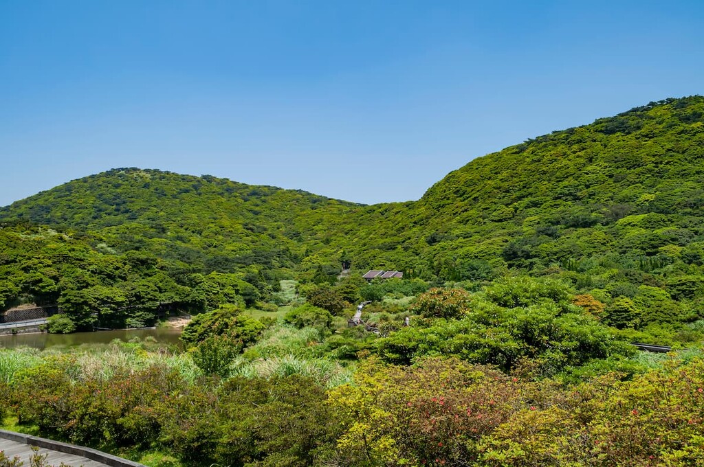
The quaintly scenic Datun Nature Park Trail is known for its gentler paced path as visitors stroll along the boardwalk lining Datun Pond to enter the warm temperate broadleaf forest. This 2.2 km (1.4 mi) loop path begins and ends in Erziping and saunters along the base of Caigongkengshan, leading to Datun Nature Park, which is built around the marshy Datun Pond.
Datun Nature Park (大屯國立公園) is perched between the saddle of Datunshan and Caigongkengshan and rests at an elevation of 800 metres (2,625 ft) along the northwest slope of Datunshan Main Peak.
Owing to this area's humidity and heavy rainfall, a wide range of aquatic plants thrive in Datun Pond. The abundant moisture also nurtures various green plants like azaleas, Formosan sweetgum, Machilus thunbergii, and a number of ferns. There are quite a lot of azaleas in the area as a result of an azalea reforestation area promoted by land managers at Yangmingshan National Park.
In the summer, Datun Pond is brimming with ducks and wild birds that in and out of the refreshing waters, which is a delightful sight to witness.
Along the Caigongkengshan Trail, visitors can see an abundance of flowers, particularly during the springtime bloom. Some of the many flower species that you can find in the park include Begonia formosana, Torenia concolor Lindley var. formosana Yamazaki, and larger clusters of Rhododendron oldhamii Maxim, all of which delicately decorate the volcanic dome of Caigongkengshan (菜公坑山).
This 1.5 km (0.9 mi) trail commences at the trailhead next to the Erziping Visitor Centre and ascends the mountain to the 887-metre (2,910 ft) summit of Caigongkengshan.
Resting on the peak of Caigongkengshan is Fanjingshi, which is otherwise known as ‘reverse compass stone.’ In fact, Fanjingshi is infamous for causing issues with navigation as the magnetic properties of this remarkable stone can decrease the accuracy of magnetic compasses.
From the summit of Caigongkengshan, hikers can distinguish views of the nearby Xiaoguanyinshan (小觀音山), the eastern Qixingshan, and parts of the north coast.
The area of Zhizihu (竹子湖) was once a crater lake; however, the water eventually dried up and became a fertile valley. The quaint farming mountain village of Zhizihu is hidden away in the mountains, perching on the foothill of Datunshan and Zhizihushan (竹子湖山). Within this abundant valley, farmers cultivate vegetables like corn, bell pepper, Chinese yam, cucumber, tomato, and calla.
Every February, stark white lily flowers burst from calla plants springing through the meadows of Zhizihu, attracting a crowd of tourists to witness this beautiful display. Visitors can also explore the nearby pine and bamboo forests and wander along the local farms in this area.
Visitors planning a stay at the Datunshan Lianfeng Special Scenic Area have a wealth of choice in terms of accommodation.
As Taiwan’s capital, Taipei City, is located just outside the Datunshan area, visitors have unlimited opportunities to entertain themselves in this thriving city. The nearby New Taipei City is also a popular choice for visitors wishing to hike Datunshan. Here are some of the best places to check out in each city:
Taipei City has a bit of everything for everyone. For history buffs, there is the stately National History Museum that displays Chinese Imperial artefacts, as well as the National Taiwan Museum, which features exhibits on the national history of Taiwan.
The commanding Presidential Palace is definitely worth a visit just for a glance at this impressively striking building. Chiang Kai-shek Memorial Hall is also a suitable contender place to visit if you’re interested in majestic architecture. Here, visitors can enjoy watching the display of the changing of the guard, which happens every hour.

The lotus-shaped 101-story building, Taipei 101, is a fascinating skyscraper that can be viewed in most areas of the city. Taipei 101 was the tallest building on Earth from its completion in 2004 until 2009, when Burj Khalifa in Dubai bested it for the world record. It is, however, the tallest building in the world to receive LEED Platinum status, meaning that it is an energy efficient building.
Additionally, Elephant Mountain is situated close to Taipei 101. Its steep stairway is a fun activity for tourists who want to capture the iconic views of Taipei 101 and its surroundings from a unique vantage point.
Taiwan is synonymous with street food, and the buzzing night markets in the city that offer wonderful looking delicacies are sure to impress. Both Taipei and New Taipei City have over 30 listed night markets, so finding a local night market will not be much of a hassle.
The well-known Shilin Night Market is centrally located in the city. If you’re looking to get slightly off the beaten path, other night markets to check out are Raohe Night Market, Ningxia Night Market, and Tonghua Night Market.
If there is one place that everyone ought to visit in New Taipei City, it’s Jiufen. This quaint spot is set in the mountains and is an old Japanese mining village overlooking the vast Pacific Ocean, with a sea of clouds sometimes obstructing the view. Wandering around the red Chinese lantern–lined alleyways of this hilltop village feels like one has been transported back in time to the late 1800s.
Yehliu Geopark is another spectacular sight of peculiarly shaped rocks along the coast of Wanli District in the icty. The Queens Head is the most famous rock in the park, and as its name suggests, the large stone resembles the shape of a poised, regal queen.

Furthermore, the green rolling hills of Sanxia Xiang Kong Tea Plantation are mesmerising and hugely popular with tea lovers. This gorgeously verdant area of the plantation is criss-crossed by three trails: a cedar forest hiking trail, a cherry blossom route, and a maple forest path.
The tranquil turquoise lake of Bitan is the focal point of the Bitan Scenic Area in Xindian. Tourists can rent a paddleboat and navigate the vast sparkling waters of Bitan Lake, which is lined with shrubbery on its shores. There are also hiking trails to explore the forested areas around the lake, which provide exceptional views of the beautiful blue lake below.
Datunshan Lianfeng Special Scenic Area is situated close to Taipei City; therefore, the journey is pretty straightforward and the options are plentiful. If you are not already based in Taipei, take the Taiwan High Speed Rail (HSR) or the Taiwan express train (TRA) to Taipei Main Station from any of the major cities.
From Taipei Main Station, you can catch the 260 Shuttle Bus, which transports you to Yangmingshan National Park. Once there, hop on the 108 bus, which circles the popular attractions of Yangmingshan National Park, and alight at the Saddle Station from where Datunshan is a 1.2 km (0.8 mi) walk away.
Another option is to take the MRT red line from Taipei Main Station to Jiantan MRT Station and then board the 260 shuttle bus and R5 bus, taking you to Yangmingshan National Park. From here, you will take the 108 bus towards Saddle Station.
Datunshan Lianfeng Special Scenic Area is also a 25 km (16 mi) journey from Taipei if one wishes to rent a car or scooter and drive there.


The highest peak in Datunshan Lianfeng Special Scenic Area is Mt. Datun, at 1,092 m.
Notable peaks in Datunshan Lianfeng Special Scenic Area include Mt. Datun, Mt. Datun West Peak, Mt. Miantian, Mt. Datun South Peak and Mt. Xiangtian.


