Scan the QR code and open PeakVisor on your phone
Prokletije National Park is a place with truly wild beauty, rocky peaks, and cold rivers. The park lies in southeastern Montenegro, bordering Albania and Kosovo. There are 76 named mountains in Prokletije National Park. Zla Kolata / Kollate e Keqe (2,535 m/ 8,316 ft) is the highest point. The most prominent mountain is Rosi Peak (2,522 m/ 8,274 ft).
This beautiful and majestic range in Montenegro rises above deep valleys, narrow canyons, and captivating lakes, a sight that is sure to leave you breathless. Prokletije might sound like a dream come true for hikers, but it's not all rainbows and unicorns. Parts of this area still remain unexplored, and some parts are hazardous.
Prokletije means damned, where those who were damned from their communities were sent. The 'Damned' national park is bursting with dramatic summits, mysterious lakes, vertiginous cliffs, and wild, untamed nature. Prokletije is the border between Montenegro, Kosovo, and Albania, and covers the far south of the Dinaric Alps.
The name itself is quite sinister, meaning, in Montenegrin, "cursed," probably referring to the difficulty of reaching the high mountains. Locals believed God cursed these mountains. Their peaks have always been a challenge, even for experienced mountain climbers.
In fact, Prokletije massif covers these three countries: Montenegro, Kosovo, and Albania. Each country protects these mountains through its own national parks. For Montenegro, it’s this Prokletije National Park. For Kosovo, it’s National Park "Bjeshkët e Nemuna." And for Albania, it’s Valbona Valley National Park.
The Prokletije Mountain Range is found along Montenegro's borders with Albania and Kosovo and contains the highest peak within Montenegro or Zla Kolata / Kollate e Keqe (2,535 m/ 8,316 ft). It lies in the southeast of Montenegro.
The park stretches over 16,630 ha (41,093 ar). National Park Prokletije is one of the youngest in the Dinaric region, since it has been a national park since 2009.
The Prokletije mountains lie in the southernmost part of the Dinaric Alps, more than 60 km (37 mi) from Skadar Lake. They also lie along Montenegro's southern border with Albania, which has two national parks in the region.

One of the most rugged mountain ranges in the Balkans or Prokletije, has more than 50 peaks that are higher than 2,000 m (6,561 ft). Some of the highest peaks are Maja Jezerce (2,694 ft/ 8,839 ft) in Albania and Zla Kolata / Kollate e Keqe (2,535 m/ 8,316 ft) in Montenegrin territory. Until a few decades back, the highest mountain peak in Montenegro was thought to be on Durmitor, Bobotov Kuk. (2,523 m/ 8,278 ft)
One of the youngest National Parks in Montenegro or Prokletije National Park, has certainly been least "touched" by human hands. The park's harsh and remote landscapes attract people with adventurous spirits. It is one of the true last backcountries of this part of Europe.
Prokletije is becoming an increasingly popular destination for hikers and climbers. In order to face the often challenging peaks, Prokletije serves as a tough final training ground before tackling other high-altitude destinations.
There are several zones in the National Park of Prokletije. The Karanfilsko-Bjelicki, Visitorska, Bogicevica, Bora, and Kofiljace zones are just some of the different kinds of ecosystems preserved here. Prokletije National Park covers two municipalities - Plav and Gusinje. Both are abundantly endowed with natural beauty.
One of the natural highlights in this area is the Hridsko Lake, surrounded by pine trees, with peaks Mali (small) and Veliki (big) Hrid reflected in its’ waters. It is said to bring beauty and health benefits to those that bathe in it.

From the capital of Montenegro, Podgorica, NP Prokletije is about 200 km (124 mi) away and can be reached by highway. The same distance separates Kosovo, with both of their capitals connected by the highway.
Although the name Prokletije means "hellish" or "damned," this beautiful area is a true paradise for all mountaineers, adventurers, and wildlife enthusiasts alike.
The relief here is jagged and contains several different features like steep slopes, river valleys, and other karstic occurrences. Glacial lakes, streams, springs, and wells provide drinking water for visitors in addition to mineral water reservoirs. River networks are present, as well as mountain lakes.

The collision of the African and Eurasian plates many years ago formed Prokletije massif. The Alps are Europe's most glaciated mountain range to the north of these mountains. Prokletije, on the other hand, is the most glaciated part of Europe south of the Alps.
They have steep limestone slopes riddled with caves and karst features. The Accursed Mountains, being a large and rugged range, is one of the few European mountain ranges yet to be fully explored.
A tectonic crash causes the curving shape of the Accursed Mountains. The rest of the Dinaric Alps prevail in a northwestern to southeastern direction. For the Prokletije, on the other hand, they turn toward the northeast to southwest. The geology of the range is mainly composed of older Mesozoic limestone, with younger Jurassic and Cretaceous dolomite.
The Park is a very nice place to visit, with small rivers, geothermal water sources, natural springs, and mountain lakes. The climate of Prokletije is much harsher in winter and chilly in the summer.
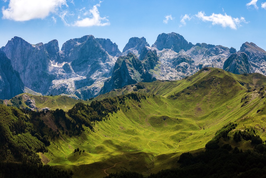
The crown peaks are located in the south of the Dinarides and at an altitude of over 2,500 m (8,202 m). Ridges, gaps and cirques, steep rockfaces, and cut valleys are the characteristics of this park. In the middle of the nineteenth century, the Austrian geologist Ami Bue announced them to be "The Alps in the South."
The natural beauty of this place is sure to be captivating. Places with mystical names such as Jura, Dobra, and Zla Kolata / Kollate e Keqe (2,535 m/ 8,316 ft), Trojan, Gvozdeni, and Šilo will surely provide a breathtaking experience.
Some of Montenegro's lakes are beautiful and worth seeing, such as Hridsko, Visitorsko, Ropojansko, Tatarijsko, Bjelaj, and Koljindarsko. Hridsko Lake, with an area of 35 000 sq. m (114,829 sq. ft) at the height of 1,970 m (6,463 ft), is one of the highest lakes in Montenegro. It is also considered by many to be the most beautiful lake in Montenegro.

With its beauty, Visitorsko Lake stands out too. It is a 1,820 m (5,971 ft) reservoir that boasts a beautiful grass island. In fact, this is a sandbank in the middle, which in past times was used as a natural shelter for cattle from beasts coming down from the mountains. The relief of Prokletije possesses numerous peaks, gorges, steep slopes, river valleys, and other natural phenomena.
The highest peaks here include:

Prokletije National Park is characterized by its’ biodiversity, which makes it one of the most distinctive areas in the Balkans. Its’ rich vegetation and diverse fauna make it a haven for eco-tourism. On the park's land, there are over 1,700 species of plants representing half of Montenegro’s flora or about 20% of the typical Balkan flora.
Currently, there are 180 Balkan endemic plants in the Prokletije mountain range, accounting for 32.4% of the total high mountain endemic flora in the western part of the Balkans.
On its territory, you will find over half of Montenegro's flora in the form of almost 40 plant communities. The vegetation of the Prokletije region is one of the richest in the Balkan Peninsula, especially regarding plant life.

The Alpine climate and diversity of animal life in the mountain region are due to its location. In the area surrounding a national park, you can see rivers, rockfaces, lakes, peaks, meadows, grasslands, and caves. In addition, this region is abundant in forests, predominantly temperate and conifer trees.
Bio-geography impacts the animal life in this area, and Prokletije is known to be part of the Alpine mountain region. This results in a high level of diversity amongst local animals. Fauna mostly inhabitates areas like high mountains, valleys of Ropojana and Grbaja, forest ecosystems, and mountain lakes.
Birds are the most important species, protected at various international and national levels. In addition to endemic species, there are these bird species present: griffon vulture, kite eagle, bearded vulture, gray heron, swallow falcon, hawk, sparrowhawk, peregrine falcon, and others.

Prokletije is home to the largest diversity of reptiles and amphibians in the entire region. Out of the 40 species within, a full 9 are endemic. It is home to black salamanders (Salamandra atra), among many other animals. Bats and rodents account for a significant number of species, as does the rabbit.
There are also programs for wild cats, intending to protect the endangered Lynx Balkanica. The most common mammal species include the wolf; you can find great deals on chamois and roe deer.
The Prokletije national park boasts a rich cultural heritage too. The park has countless sites, fortresses, churches, mosques, and settlements, in addition to features such as folklore beliefs and ethnological diversity.
The remains of settlements and human inhabitation date back to the Palaeolithic, Copper, and Bronze Ages and from the time of the Illyrians and the Roman Empire. From the Middle Ages, many remains of religious buildings and defenses were found. Of course, many monuments play tribute to the Ottoman influence from the time of their reign here.
Remnants from earlier periods of prehistory bear witness to the existence of human life here. Drawings carved into the rock on the Vezirova Brada lit. Vizier's chin rock near Grebaje shows this. Many facilities are due to their architectural, artistic, and historical value.
Many buildings are declared monuments due to their architectural, artistic, and historical values. Plav has an old mosque from the fifteenth century and Redžepagića Tower in the village. St Brezojevica church also lying in the countryside. Gusinje built the Vizier mosque in the eighteenth century.
The traditional architecture of this area was preserved in the form of residential houses, which were made from wood, a mixture of wood and stone, or only from stone. An ethnographic wealth characterizes the area, this is shown in the variety of dress and music, as well as local customs and handicrafts.
Many architectural, artistic, and historical sites considered for UNESCO designation due to their cultural value. The same goes for folklore, music, and other customs, which are of great ethnographic significance. Many preserved buildings today serve as monuments to this way of life.
National Park Prokletije is one of the youngest national parks in the Dinaric region. It became a National Park in 2009. Still, locals protected these mountains as their own for decades, both for farming and as natural wonders.

Hiking in Prokletije National Park is a must-see, because it shows you the park's best features. Here are the best hiking options:
Of the numerous lakes in Montenegro, Hridsko’s (Ridsko) beauty and uniqueness make it stand out. It lies in the northern part of the Prokletije National Park at an altitude of 1,970 m (6,463 ft).
You'll find the trailhead near Plav, and his trail is easy to complete. It takes around 1.5 h to reach the lake, with minimal elevation gain. This trail is perfect for hiking in the afternoon, as a hike with kids, or just a short hike, since it is only 3.5 km (2 mi) in length.

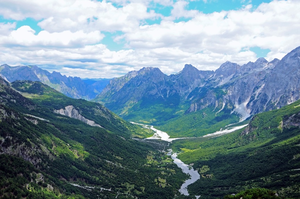
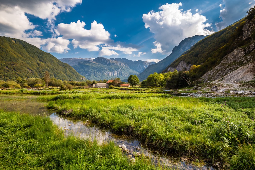
Another popular but also undemanding hike is around Grebaja Valley. You can head out from Gusinje to reach it or leave your car at the valley's entrance and hike through it.
Grebaja is famously recognized for its flat base, where four big fields dominate, cut by the Valušnički brook, which is dry during summer. It's 2 km (1.2 mi) long. During the mid-nineteenth century, the Grebaja meadow was the site of a shepherd's hut.
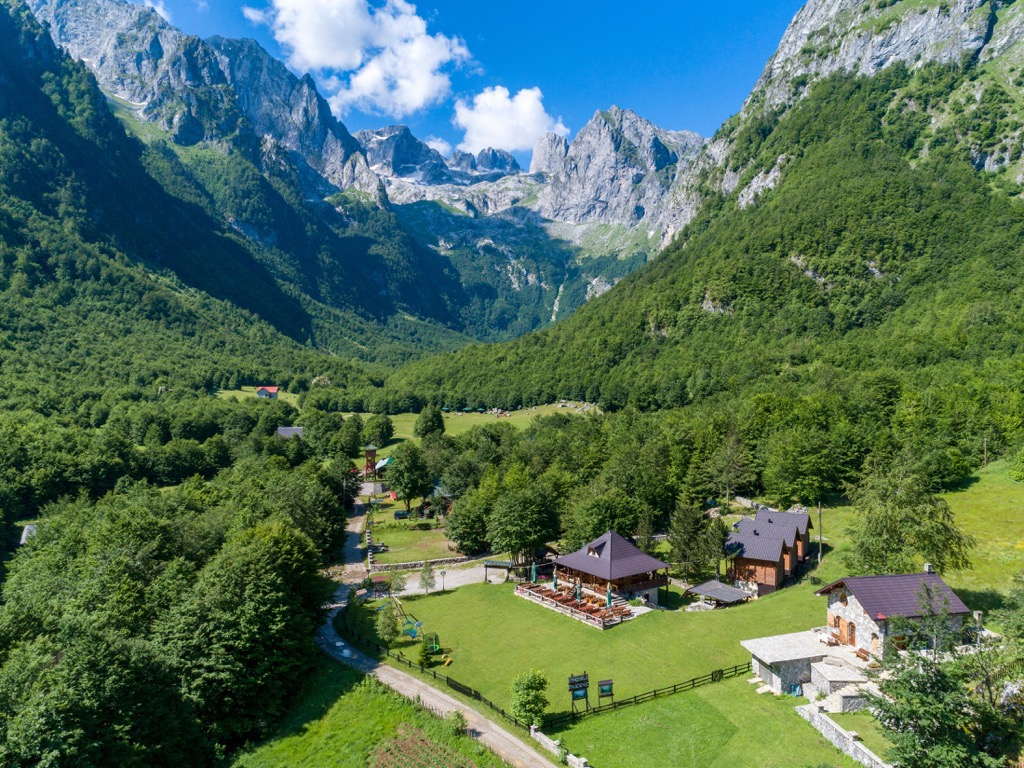
Today, this became a mountain lodge. The lodge owned by a local hiking club Kranfili, and called Karanfili mountain lodge. The only remaining water source is next to the conifer forest, meaning there is no more drinking water in Grebaja anymore. This is Suljova česma, the last of its kind.

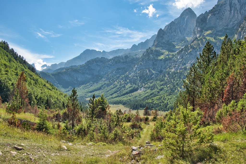
Krosnja is a relatively steep, rewarding hike that gives you even more views of Grebaje. It's the perfect hiking option if you're visiting Montenegro and need a day's worth of exercise on the slopes around the Karanfil ridge.
The Šuplja vrata, or “Kissing Cats” arch, will lead you almost straight to a beautiful view of the mountains. You get to see plenty of wildflowers growing near the arch and can keep climbing to be rewarded with some new views!
This hike is well-marked and easily accessible. It will take 6 hours total to complete, and it would be wise to start early in the morning for the best temperature conditions.

The highest point of Montenegro is the Zla Kolata / Kollate e Keqe (2,535 m/ 8,316 ft) mountain peak, which is close to the Albanian border. It's possible to reach the top of Zla Kolata and return in one day, but you'll have to know your route or take a guide.
You'll need to prepare for an adventurous day full of high temperatures, rugged terrain, and sure footing. The hike takes all day, 3 hours of descent and 4 hours of ascent, and an elevation gain of 1,500 m (4,921 ft). Of course, one can stretch the hike into two days with the same route.

Next up are the nearest bigger cities you can visit when spending time at Prokletije National Park:
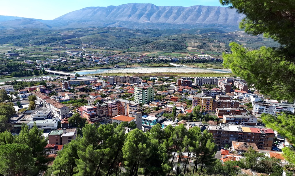
Gusinje is a small town in Montenegro. It lies on the slopes of Prokletije at an altitude of 1,000 m (3,280 ft). The town has a population of about 2,000 people and it is one of the most popular tourist destinations in Montenegro.
The town was first mentioned in historical documents in 1485, and the Ottoman Empire founded it. You can reach Gusinje via road and enjoy the town in numerous apartments, campsites, and rental cottages.
You can also visit Plav in Montenegro, which lies to the east of Gusinje. Plav region's biggest natural attraction is Lake Plav, the largest glacial lake in the Balkans.
It's also the spring of the Lim River, one of Montenegro's most significant rivers. Plav is a small town but also an entrance to Prokletije. One can reach it via road and stay here in budget campsites, huts, and cottages.
Peja is a big town in Kosovo. It is located in the east of the country, near the border with Albania. The town has a population of about 100,000 people and it has been inhabited since ancient times.
The town has been farming since the Ottoman Empire was ruling the region. Recently, it has become more popular as a tourist destination because of its natural beauty and cultural heritage. Reach it via road, air, and rail, and stay here in all types of accommodation options.