Scan the QR code and open PeakVisor on your phone
Lantau South Country Park is a vast expanse of rugged countryside on Lantau Island in the Hong Kong Special Administrative Region of China. There are 45 named peaks in the park. The highest and most prominent one is Lantau Peak.
Spanning 56 square kilometers (21.6 sq. miles) on the western reaches of Hong Kong, Lantau South Country Park is the biggest country park in the city. It occupies 40 percent of the land area on Lantau, the largest island in the territory.
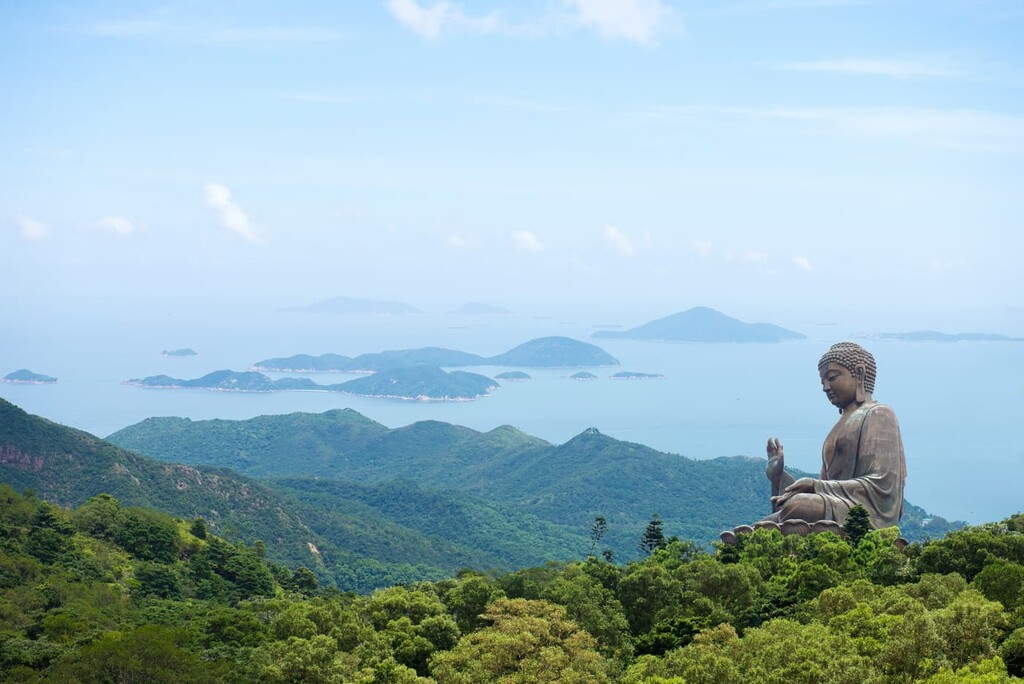
The park is connected to Lantau North Country Park to the north and the seaside town of Mui Wo to the east. The western end of the park is also the westernmost area in Hong Kong. In the Ngong Ping area below Lantau Peak, the park borders on some of the city’s top attractions like Po Lin Monastery and the 34-meter (112-ft) Big Buddha bronze statue.
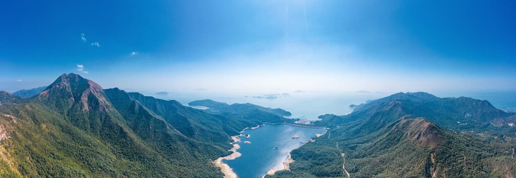
Apart from its numerous peaks, the park boasts plenty of coastline with the peninsulas of Chi Ma Wan and Shui Hau within its borders, as well as the coastal areas of Yi O and Fan Lau. It is also home to Shek Pik Reservoir and a much smaller irrigation reservoir, Shap Long Reservoir. There are many streams with pools and waterfalls such as Man Cheung Po Infinity Pool.
Vehicular access to the South Lantau area is limited and highly restricted. Motorists are required to have a “Lantau Closed Road Permit” to drive in the area, but in an attempt to promote local tourism, the government has recently introduced a quota system that allows the public to apply for a single-use permit.
Most of the rocks in the park are igneous rocks, as is the case in the rest of Lantau Island. The peaks are largely made up of volcanic rocks which are relatively resistant to normal subtropical weathering processes, while the lowlands abound with granitic rocks, especially in the eastern part.
The igneous rocks were produced by a volcanic episode in the late Jurassic period between 146 to 148 million years ago, which resulted in a major caldera in what is now central Lantau. The subsequent collapse of the caldera may be caused by explosive eruptions. Meanwhile, viscous lava flows formed the flow structures widely seen in the rocks today.
Chi Ma Wan peninsula has a boulder field and some interesting rock formations such as Fat Pig Rock and cavity features called tafoni, also known as “Swiss-cheese rocks.” The area around Kau Nga Ling and the southern side of Lantau Peak is another place to marvel at formations such as Hades’ Wall and King Tin Gorge.
Until the 1950s, there were freestone quarrying operations along the granite coastline, especially on Chi Ma Wan peninsula where the granite is evenly textured and medium-grained. Stones were traditionally cut here for use as construction materials.
The park’s far-flung location allows wildlife to thrive, with large tracts of secondary forests sustaining a diversity of animals. Native plant species include tree ginseng (Dendropanax dentigerus), Hong Kong magnolia (Magnolia championii) and the rare little-leafed rourea (Gmelina chinensis).
There are extensive plantations in the catchment area of Shek Pik Reservoir, where the vegetation had been disturbed by construction, and in places affected by wildfires and erosion. At the beginning, adaptable and fast-growing introduced species were planted because of infertile soil, and trees such as slash pine (Pinus elliottii), Brisbane box (Lophostemon confertus) and Taiwan acacia (Acacia confusa) have since taken firm root.
Afforestation in more recent years has seen the addition of sturdy native species such as camphor tree (Cinnamomum camphora), Chinese banyan (Ficus microcarpa), Chinese hackberry (Celtis sinensis) and lidded cleistocalyx (Cleistocalyx operculatus).
The peninsula of Shui Hau and the area of Ngong Ping to the north of Lantau Peak are hotspots for butterflies, with over 100 species calling each location home. In particular, three rare species—striped bush hopper, Tamil grass dart and large tree-ring—are known as the “Three Treasures of Ngong Ping.”
Nearly 200 bird species have been recorded in Chi Ma Wan peninsula alone. Birds of conservation value include brown fish owl, Malayan night heron and smew. Upland meadows in the park harbour highland birds such as Chinese grassbird and upland pipit, while coastal wetlands provide wintering grounds for migratory birds.
Moreover, the wetlands are sanctuaries for horseshoe crabs and mudskippers, while waterways shelter fish species like paradise fish and blue neon goby. Amphibians such as the endemic Romer’s tree frog also thrive in the wetlands and woodlands.
Cattle and water buffalos descended from draught animals are now part of the wildlife scene in the region following the decline of farming activities. Other mammals found in the park include red muntjac and Pallas’s squirrel.
The waters around the island, especially on the west coast, are home to the highly threatened pink dolphin, which can sometimes be spotted on land at elevated points.
Human presence in the park area and the rest of the island dates back to the Neolithic. There are rock carvings at Shek Pik and a stone circle at Fan Lau that are preserved from that time.
For many centuries, villagers made a living by fishing, and by harvesting both salt and lime. Ancient lime kilns from the Tang Dynasty nearly 1,400 years ago still remain on a beach on Chi Ma Wan peninsula.
Lantau Island used to be a stronghold of defense, navigation and trade in China because of its proximity to the mouth of Pearl River, one of the most important waterways in southeast China. Its location also attracted pirates, smugglers and European traders.
In the early 1700s, the provincial government of Guangdong built forts and deployed troops at different locations on the island, starting at Fan Lau on the southwestern end. The walls of Fan Lau Fort still stand though the guns have long gone.
Following the colonization of Hong Kong in the 1840s by the British, who chose to establish the administrative center on Hong Kong Island, Lantau became an outlying backwater of rural settlements, temples and monasteries.
During World War II, the island was an important base of the resistance movement against the Japanese. Even though it was not a major battleground, ambushes were organized and supplies were moved under cover of the rugged, forested terrain.
When the Japanese surrendered in 1945, some of the occupying Japanese soldiers on the island held out and set fire to villages in Mui Wo. They kidnapped hundreds of villagers, some of which were tortured to death.
The remote location and availability of land in Lantau South make it a suitable area for building correctional institutions. The area houses several facilities just beyond the park borders, including the maximum-security Shek Pik Prison next to its eponymous reservoir.
To this day, Lantau South remains relatively undeveloped and sparsely populated despite rapid development in Lantau North.
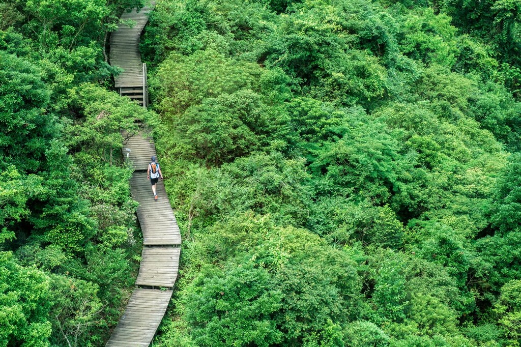
The park has an extensive network of hiking trails, the most important of which is the 70-km (43-mi) Lantau Trail that basically loops around the park in 12 sections. The following are the major hiking areas for visitors to check out:
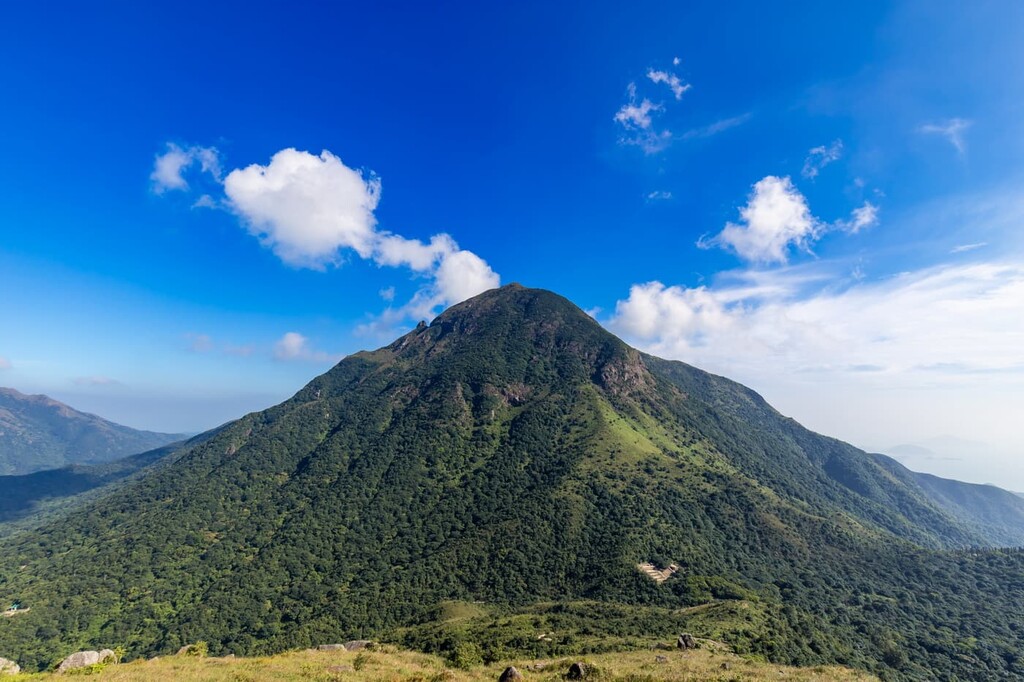
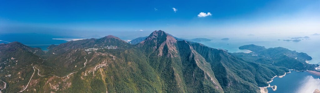
Towering above the island, Lantau Peak is the second highest peak in Hong Kong and the number one location for watching the sunrise.
Many hikers stay the night at the campsite or the youth hostel at Ngong Ping before setting off on Lantau Trail in the wee hours. For those who prefer setting off later in the day, sweeping views of Lantau’s seascape and idyllic countryside are an enough reason to take the strenuous hike.
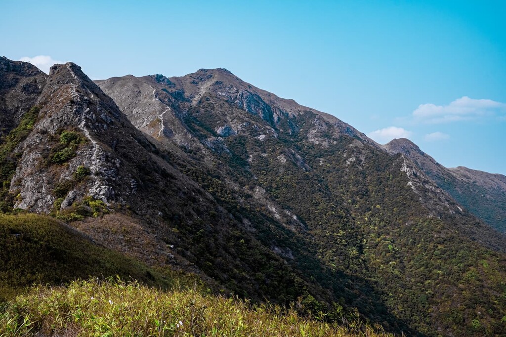
Lantau Peak is connected to Kau Nga Ling—literally “Dog Teeth Range” in Chinese—which consists of three ridges--Middle Dog Teeth, East Dog Teeth and the most challenging West Dog Teeth. All three teeth are very steep with dramatic rock formations and cliffs that are a sight to behold but also a hazard to hikers. This route is usually approached from the south at Shek Pik Reservoir to end at Ngong Ping in the north.
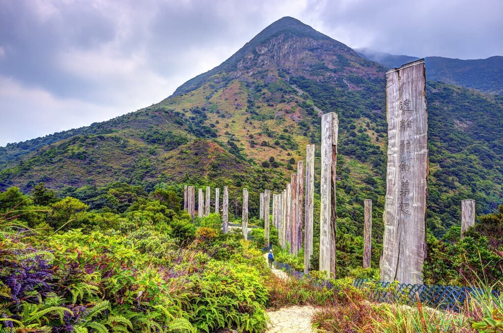
When you reach Ngong Ping, it’s hard to miss the Wisdom Path, a collection of 38 wooden columns engraved with verses from the Heart Sutra written in Chinese calligraphy by the late master scholar, Jao Tsung-I.
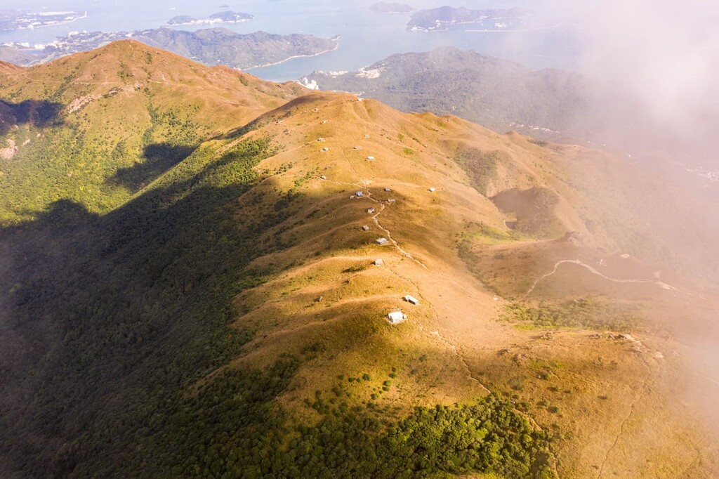
Located on the eastern side of the park, this area includes the connecting hills of Sunset Peak and Yi Tong Shan. The silvergrass growing in abundance on the hills gives them a beige color instead of the lush green on other hills. The area is most popular in the fall when the silvergrass turns golden yellow.
Sunset Peak (869 m/ 2,851 ft) is the third highest peak in Hong Kong while Yi Tong Shan (749 m/ 2,457 ft) is the ninth highest. The highland between the two is the site of Lantau Mountain Camp, a landmark in the form of 20 rough-hewn single-story stone cabins, which were built as vacation homes by missionaries in the 1920s. Some of them are still owned by religious organizations while some have been sold to private owners.
The peaks are among the most easily accessible ones in the park, as the hike can start right in the gateway neighborhood of Tung Chung on the northern side. Less experienced hikers are recommended to take a bus to the southern side at Pak Kung Au and make a round trip from there.
Chi Ma Wan, literally meaning “sesame bay” in Chinese, is a peninsula jutting out of southeastern Lantau. The two peaks in the area, Lo Yan Shan and Miu Tsai Tun, are only about 300 m (984 ft) in height but offer amazing views of the South China Sea and Pui O Beach.
At the neck of the peninsula is Shap Long, which has a well-shaded campsite, a secluded reservoir and a herd of feral water buffalo. There is a boulder field between Shap Long and Lo Yan Shan.
The 18-km (11-mi) Chi Ma Wan Country Trail leads to all those places, as well as the entire west coast of the peninsula that contains a quiet beach at Mong Tung Wan. The area can be reached from the community of Pui O or by boat from Mui Wo or Cheung Chau island.
The part of the park lying to the west of Shek Pik Reservoir includes the headland of Fan Lau, the old village of Yi O, the bays of Tai Long Wan and Tsin Yue Wan, as well as several peaks. There are a few campsites in the area.
Fan Lau literally means “separation of currents” in Chinese. The waters off the headland often come in two colors—a clear turquoise blue from saltwater in the South China Sea, and a muddy yellow from freshwater flowing out of Pearl River in Mainland China.
Being one of the most remote places in Hong Kong, Fan Lau reputedly has only one resident, Mr. Chan, who sells food and drinks to hikers a few days each month. Among the splendid isolation are a few signs of civilization or past civilization, such as an overgrown fort, a Neolithic stone circle, abandoned village houses and a well-maintained Tin Hau Temple (or Temple of the Sea Goddess).
Yi O was once an abandoned village which has seen a restoration of farming activities in recent years. The land is still in private hands despite having been incorporated into the country park. It is a common exit point for hikers, but there have been incidents of villagers prohibiting hikers from passing through their land.
Tung Chung in northern Lantau and Mui Wo on the eastern side are the major gateway neighborhoods to the park.
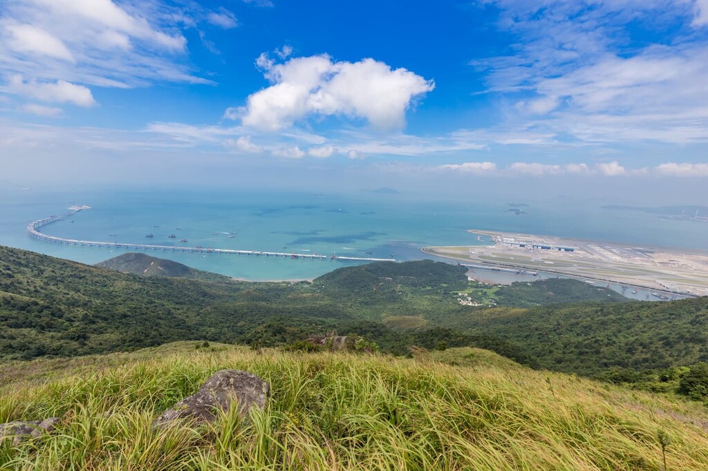
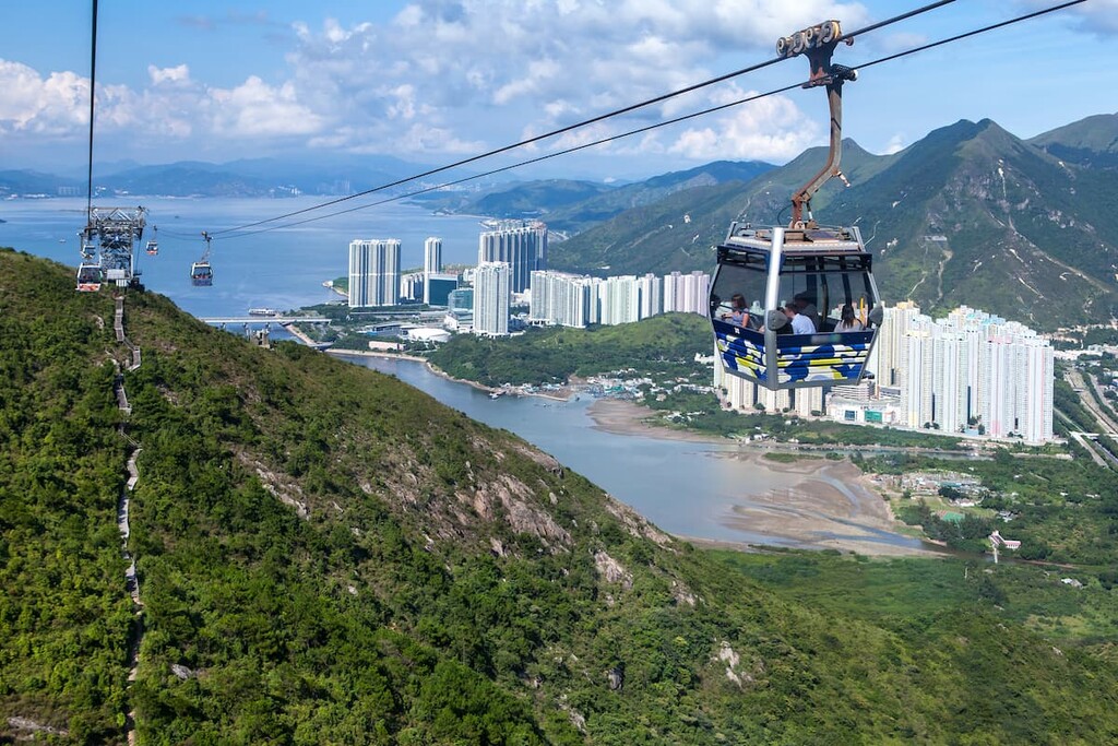
Tung Chung had been a rural fishing community until the 1990s, when the Hong Kong Airport was relocated to northern Lantau. Part of the plan was to develop Tung Chung into a new town, resulting in large residential complexes, land transport links to the urban areas, and more recently, the cross-boundary Hong Kong–Zhuhai–Macao Bridge. Attractions include the historic Tung Chung Fort and a scenic cableway that goes up to Ngong Ping.
Mui Wo, a laid-back beachside town with about 6,000 residents, is connected to Central on Hong Kong Island by ferry. The town is popular with weekend visitors who seek to escape the city hubbub, and has many cafes, restaurants, shops and a few seaside resorts.
There are plenty of activities and attractions to choose from, including swimming, paddling, biking, visiting the waterfalls and a former mining cave, just to name a few.