
Scan the QR code and open PeakVisor on your phone
The area around what is now known as Costilla County in south-central Colorado was the first part of the state settled by European-Americans in the mid-19th century. The county seat is the small town of San Luis, with an estimated population of only 658 inhabitants (the entire county’s population as of 2019 is only 3,887). First established by Hispanic settlers from Taos, New Mexico, on April 9, 1851, San Luis is the oldest continuously inhabited town in Colorado. The county was one of the original 17 counties created by the Territory of Colorado on November 1, 1861, named for Costilla Creek. This all happened before Colorado was admitted to the Union as the 38th state on August 1, 1876.
The county is located in the immense San Luis Valley situated between the San Juan Mountains on the west and the Sangre de Cristo Range on the east. The valley, a high-altitude depositional basin of about 8,000 square miles extends partly into the state of New Mexico to the south. Having an average elevation of 7,664 feet, the valley is part of the Rio Grande Rift, drained by the Rio Grande River. Most of the land in Costilla County is therefore flat and agricultural in nature. If you fly over the valley, you will see hundreds of center-pivot irrigation circles all over the valley (check it out on Google Earth).Only the northern and eastern fringes of the county are known for high mountains - all of which are in the Sangre de Cristo Range. And some of these are formidable peaks, including four of the state’s fourteeners. So, while one would think that Costilla County is not known as a destination for hiking and climbing, there are some fine surprises in store for those who come here for that reason.

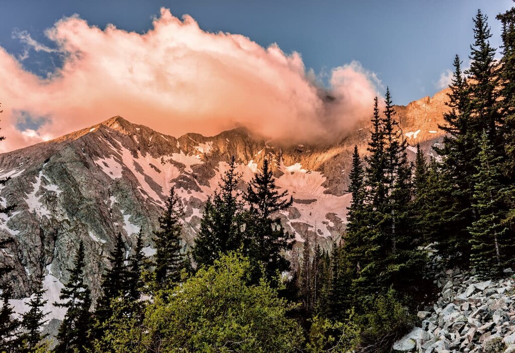
There are 34 named mountains in Costilla County, with Blanca Peak both the highest and most prominent of them all. This monster of a mountain is one of only three ultra-prominent peaks (at least 1,500 meters or 4,921 feet of topographic prominence) in Colorado – it is also the fourth highest mountain in the state as well as in the entire Rocky Mountains of North America. It, along with its adjacent cluster of other fourteeners, only one of which is not in the county, offers some of the most spectacular, and dangerous, climbs anywhere in the lower 48 states. These mountains are not for casual hikers. There are three highways that cross parts of the county – State Highways 142 and 159, and U.S. Highway 160. The latter is the only highway crossing the entire southern part of the state from east to west. There are no airports in the county, though the small regional airport in adjacent Alamosa County does provide limited scheduled airline service. A car is your best way to get around.
Costilla County is certainly not one of the foremost hiking destinations in Colorado. For one thing, it is far from the major population centers in the state. I have never hiked here for the simple reason that it is a long drive from where we live. There are just too many fantastic places to hike much closer to home. From the Denver area, just to the town of San Luis is a four-hour drive, although to get to the trailheads of the Blanca Massif would be a bit shorter. But even then, day-hikes from home would be out of the question. That means most people who want to hike here will need to find accommodations – either by camping or staying in motels or inns, which are not in abundance in this area, although Alamosa not far away offers a decent selection. There are mainly two areas to go hiking here, so let’s have a look at the options.
This massive cluster of fourteeners is undoubtedly the best and most popular hiking area in Costilla County. Well, at least three of the four summits are in the county (Little Bear, Blanca and Lindsey), but the problem is accessing them from within county boundaries. Aside from the fact that the approaches from the south are long and difficult, the southern slopes of this massif are mostly on private property. That leaves the only viable access routes to these fine summits starting at trailheads located in the adjacent Alamosa and Huerfano Counties. But since these peaks are significant attributes of Costilla County, it is important to include them here.

The most widely used trailhead is the Lake Como Trailhead in Alamosa County. This is the main staging point for climbs of Blanca Peak, Little Bear Peak and Ellingwood Point (the latter is not in the county). It is about 20 miles from the city of Alamosa and 11 miles from the small town of Blanca in Costilla County. At 8,000 feet elevation, it is the lowest trailhead in Colorado for climbing fourteeners. It is theoretically possible to drive all the way to Lake Como at 11,750 feet, another five miles up the road, but that involves negotiating the most challenging four-wheel drive road in Colorado, which is only possible with specially modified vehicles. Most vehicles stop at the lower location, though some continue on up to 10,000 feet and park somewhere along the road, depending on their comfort level.

At any rate, those wishing to climb the high peaks will likely camp at Lake Como before making their ascent. This then is the primary staging point for climbing these peaks. Casual hikers don't usually come up here, although Lake Como is very scenic. The only trail to the lake is the jeep road and it is very unpleasant to hike, not to mention very hot on summer afternoons. The ridge connecting Little Bear and Blanca is considered Colorado’s most difficult fourteener traverse. The author of the preeminent fourteeners guide book advises you to consider your future before you attempt this one-mile ridge. He says this is one unhappy place to be during a storm, and bailing from the ridge is difficult at best. This ridge follows the Alamosa/Costilla County line. It was probably unnecessary for early surveyors to make that traverse in order to establish benchmarks up there.

The fourth most prominent and third highest mountain in Costilla County is Mount Lindsey, which is located entirely within county boundaries. Yet almost all of this solitary mountain’s southern slopes, including the summit, are on private property. There is no public access to the mountain from within Costilla County - one must approach it from the Huerfano River Trailhead from the north in Huerfano County. At 10,660 feet, the trailhead can be reached by most passenger cars, although the last two miles on this forest road can be quite rough so that 4WD or high-clearance vehicles are advised. The standard route to the summit is not the easiest on the mountain but it is the easiest route that is available to the public. The climb is a Class 2+ undertaking involving some loose rock on the mountain’s north face. An airy Class 3 scramble can be used as an alternative that avoids the loose rock.

If you are driving south from the tiny town of Fort Garland toward San Luis and beyond toward New Mexico, you will see an impressive wall of high peaks to your left (east). This is the Culebra Range – about 25 miles long and home of the southernmost fourteener in Colorado, in addition to numerous thirteeners. If you didn’t know better, you would naturally assume that this must be prime hiking country. It is – probably some of the most pristine hiking terrain in the state. The problem – most of this range is in the private hands of one landowner. And nobody is permitted to hike there with one notable exception. While the east side of the range has a limited number of access points into the range, the west side has only one. Yes, it is the one that lets you climb the only fourteener in the range – Culebra Peak.

Cielo Vista Ranch is the property on which this fine mountain sits (in addition to 18 thirteeners). And if you want to climb it, you will pay a hefty fee – as much as $150 per person as of summer 2020. It is the southernmost fourteener not only in Colorado but in the entire Rocky Mountains of North America. It is also the fourth most topographically prominent peak in the state. Despite this, Culebra is an easy mountain to climb. In fact, it is hardly a climb - a Class 2 walk-up hike would be more appropriate. There is a benefit to be realized by paying the fee to climb Culebra - it is the fact that this mountain is completely unspoiled and pristine. When compared to so many of the most popular fourteeners that are overrun and trashed out by hikers, there is something to be said for this. After all, a one-day lift ticket at some of the bigger ski areas can cost a lot more than the $150 fee. Yet some “peak baggers” choose to exclude this peak from their list of fourteeners. They call themselves the ABC group – All But Culebra. But it may well be worth the price for the solitude of a quiet hiking experience, where you are likely to encounter wildlife unencumbered by masses of hikers.

Given how small Costilla County is, one must not expect to find any major towns here, and certainly no resorts of any stature. The few towns that are in the county are so small that some will say that whoever lives in these towns “knows everyone else in town”. That is a bit of a stretch, but it clearly defines how rural these places are. Traffic lights? Not even one to be found in the entire county. Yet a couple of the “larger” towns have a sense of western charm, not to mention killer views of the mountains, as well as a bit of history to share with the “influx” of visitors. If you like quiet, then you will feel right at home here – as long as you can find a place to sleep and eat. Of course, you can drive a mere 20 miles to the much larger town of Alamosa in the adjacent county of the same name. There you will certainly find tourist amenities to your liking – as long as you don’t expect ultra high-end accommodations.
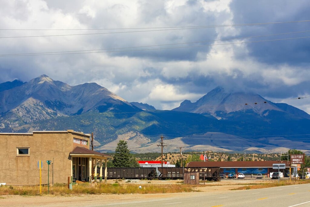
This small town of 433 inhabitants is located at the crossroads of U.S. Highway 160 and State Highway159 and will likely be your best bet for lodging and restaurants. The town was established as an army base in June of 1858 in order to protect the San Luis Valley settlers from attack by the Ute Indians. The fort was abandoned in 1883 after the tribes were confined to an Indian reservation in parts of Utah and Colorado. The Fort Garland Museum preserves some historic buildings from the fort and might be an attraction to see on a rainy day – which is rare in this county. Just four miles to the west is the even smaller town of Blanca with a population of only 406 as of 2019.
This small town, the county seat, was once called San Luis de Culebra in honor of its patron saint and is the largest town in Costilla County, with a 2019 population of 658. A local newspaper article of June 8, 1872 described San Luis as having three stores, a blacksmith, butcher, beer saloon carpenter and two hotels. The town has slightly more establishments today, although one cannot say that it is a bustling metropolis by any means. It does, however, have several points of interest including the Shrine of the Stations of the Cross and the Sangre de Cristo Heritage Center. The shrine sits on a low hill at the edge of the town and offers an easy but interesting hike suitable for all family members. It imparts a sense of the religious devotion of the early settlers in this valley. The view of the town and the surrounding mountains is very fine from the top which rises about 200 feet above the surroundings. Probably the easiest hike in the county.

If you are planning to recreate in Costilla County and need a place to stay, your best bet is Alamosa. Though it is not in this county but in adjacent Alamosa County, travel distances to the hiking places are relatively short. Alamosa is in the middle of the immense San Luis Valley, which forms the western edge of the Sangre de Cristo Range in Colorado. With a population of less than 9,000, this is by far the largest town anywhere close to this mountain chain. Yet, the town offers almost any amenity that a visitor would require for an extended stay to explore these mountains - accommodations, restaurants, hospital, golf course, shopping and even an airport with regional scheduled service including to Denver and Albuquerque, New Mexico. This is the place to stay for the best hiking access to the Blanca Massif. From Alamosa to the Culebra Peak trailhead is only 50 miles and less than one hour. The same trailhead can be reached from San Luis in far less time, but you may have less choice of places to stay.


