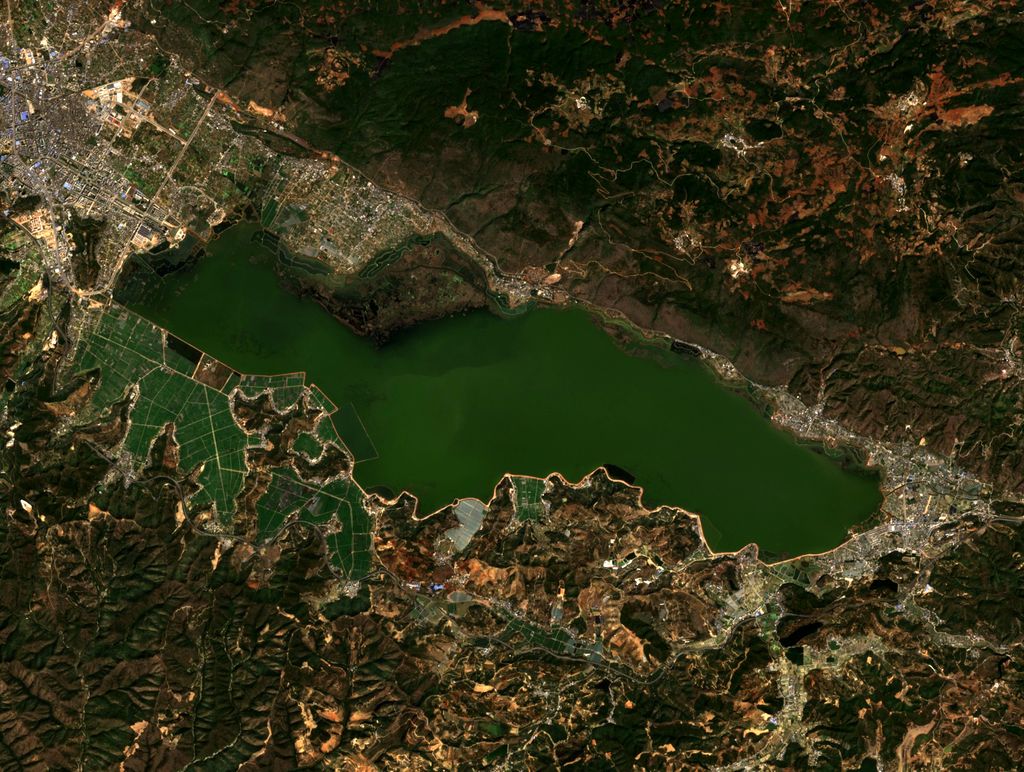
Yilong Lake (simplified Chinese: 异龙湖; traditional Chinese: 異龍湖; pinyin: Yìlóng Hú) is a large freshwater lake located in Shiping County, Honghe Prefecture, Yunnan province, southwestern China. The lake has a surface area of approximately 32 square kilometres (12 sq mi) and is particularly notable for its scenery, including the colorful lotus flowers that bloom on its surface. It is located about 2 kilometres (1.2 mi) east of the county seat. The people who live in the vicinity of the lake are largely of the Yi ethnic group. As of the spring of 2013 a severe drought had resulted in substantial lowering of the water level. The lake is one of the most-visited destinations in the Yunnan-Guizhou Plateau. It used to be called Yulong Lake, an allusion to the Yulong Mountain that lies to the lake's south. The change of name has mythological reasons. It is believed that in 1629, the dragon believed to live in the lake ascended to heaven in broad daylight, prompting the change in the lake's name. Not much is known about how the lake formed. Records tell that the lake formed during the Qin and Han dynasties. The lake is situated at an elevation of 1414 meters above sea level. It is 15 kilometers long, east to west. It is 3 kilometers wide. The lake's holds 220 million cubic meters of water. Its average depth is 4 meters.
Show more
Sun and Moon
Mon
Tue
Wed
Thu
Fri
Sat
Sun
May 2022
Date and time
00:00
06:00
12:00
18:00
Today
--
--
Sunrise
--
Sunset
--
Moonrise
--
Moonset
Phase
🌔 Waxing Gibbous
The perfect light time for beautiful photos:
--
Sunrise
--
Sunset
PeakVisor app
Get the app on your smartphone
New Panorama Tools
Trace location on the map
Measure distances
All the instruments are available in the context menu as well.
We use GPS information embedded into the photo when it is available.
3D mountains overlay
Adjust mountain panorama to perfectly match your photos because recorded by camera photo position might be imprecise.
Move tool
Rotate tool
Zoom
More customization
Choose which peak labels should make into the final photo and what photo title should be.
Next
Photo Location
Satellitte
Flat map
Relief map
Latitude
Longitude
Altitude
OR
Latitude
°'''
Longitude
°'''
Apply
Register Peak
Peak Name
Latitude
Longitude
Altitude
Register
Teleport
PeakVisor
This 3D model of Sagarmatha National Park in Nepal was made using the PeakVisor app topographic data. The mobile app features higher precision models worldwide, more topographic details, and works offline. Download PeakVisor maps today.
Download OBJ model
PeakVisor
The download should start shortly. If you find it useful please consider supporting the PeakVisor app.
PeakVisor for iOS and Android
Be a superhero of outdoor navigation with state-of-the-art 3D maps and mountain identification in the palm of your hand!