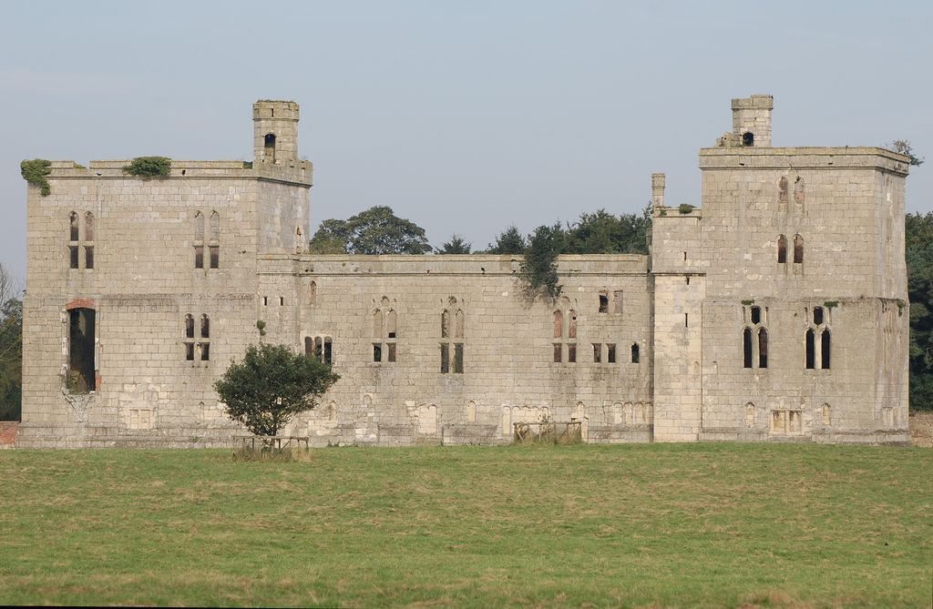
Wressle Castle is a ruined palace-fortress in the East Riding of Yorkshire, England, built for Thomas Percy in the 1390s. It is privately owned and it is usually open to the public for a few days each year. Wressle Castle originally consisted of four ranges built around a central courtyard; there was a tower at each corner, and the structure was entered through a gatehouse in the east wall, facing the village. After Thomas Percy was executed for rebelling against Henry IV, Wressle Castle was confiscated by the Crown. With occasional periods when it was granted to other people, the castle was mostly under royal control until 1471 when it was returned to the Percy family. Henry Percy, 5th Earl of Northumberland, refurbished the castle and gardens, bringing them to the standard of royal properties. The castle was embedded within an ornamental landscape, with two gardens laid out at the same time as the castle was founded and a third created later. Wressle was intended as a high-status residence rather than a fortress and was never besieged. However, it was held by Parliament during the English Civil War and partly demolished in 1646–50, leaving the south range still standing. Nearly 150 years later, it was further damaged by a fire that struck the house. In the 21st century, Historic England, Natural England and the Country Houses Foundation funded repairs to the castle ruins.
Show more
Sun and Moon
Mon
Tue
Wed
Thu
Fri
Sat
Sun
May 2022
Date and time
00:00
06:00
12:00
18:00
Today
--
--
Sunrise
--
Sunset
--
Moonrise
--
Moonset
Phase
🌔 Waxing Gibbous
The perfect light time for beautiful photos:
--
Sunrise
--
Sunset
PeakVisor app
Get the app on your smartphone
New Panorama Tools
Trace location on the map
Measure distances
All the instruments are available in the context menu as well.
We use GPS information embedded into the photo when it is available.
3D mountains overlay
Adjust mountain panorama to perfectly match your photos because recorded by camera photo position might be imprecise.
Move tool
Rotate tool
Zoom
More customization
Choose which peak labels should make into the final photo and what photo title should be.
Next
Photo Location
Satellitte
Flat map
Relief map
Latitude
Longitude
Altitude
OR
Latitude
°'''
Longitude
°'''
Apply
Register Peak
Peak Name
Latitude
Longitude
Altitude
Register
Teleport
PeakVisor
This 3D model of Sagarmatha National Park in Nepal was made using the PeakVisor app topographic data. The mobile app features higher precision models worldwide, more topographic details, and works offline. Download PeakVisor maps today.
Download OBJ model
PeakVisor
The download should start shortly. If you find it useful please consider supporting the PeakVisor app.
PeakVisor for iOS and Android
Be a superhero of outdoor navigation with state-of-the-art 3D maps and mountain identification in the palm of your hand!