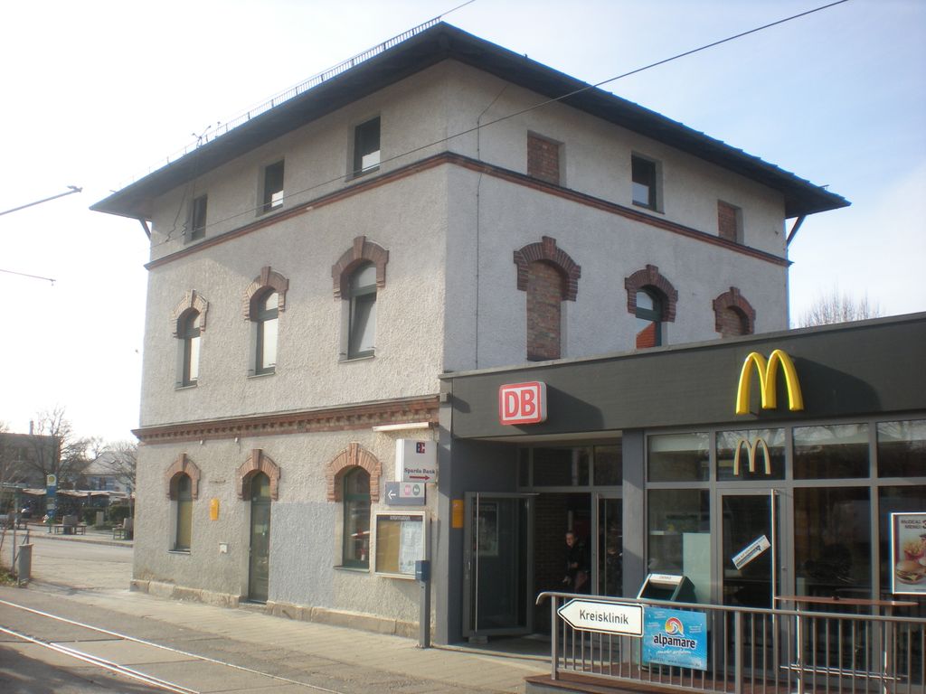
Wolfratshausen station is a station of the Munich S-Bahn. It is located in the Upper Bavarian town of Wolfratshausen in Germany. It is classified by Deutsche Bahn as a category 6 station. It has two platform tracks next to a central platform. The station is located in the network area of the Münchner Verkehrs- und Tarifverbund (Munich Transport and Tariff Association, MVV) and is served by line 7 of the S-Bahn, which is operated by Deutsche Bahn. The station was established on 27 July 1891 as a terminus when the Isar Valley Railway from Munich was put into operation. The line was built and operated by Lokalbahn AG (LAG). The station became a through station on 1 June 1897 when the Isar Valley Railway was extended to Eurasburg. In 1898, the line was extended from Eurasburg to Bichl. Until the nationalisation of the LAG in 1938 the Wolfratshausen station included a locomotive depot. From 1957 to 27 May 1972 Deutsche Bundesbahn closed the line between Bichl and Wolfratshausen in several stages, so that Wolfratshausen station became a terminus. On 28 May 1972, S-Bahn services began between Munich and Wolfratshausen.
Show more
Sun and Moon
Mon
Tue
Wed
Thu
Fri
Sat
Sun
May 2022
Date and time
00:00
06:00
12:00
18:00
Today
--
--
Sunrise
--
Sunset
--
Moonrise
--
Moonset
Phase
🌔 Waxing Gibbous
The perfect light time for beautiful photos:
--
Sunrise
--
Sunset
PeakVisor app
Get the app on your smartphone
New Panorama Tools
Trace location on the map
Measure distances
All the instruments are available in the context menu as well.
We use GPS information embedded into the photo when it is available.
3D mountains overlay
Adjust mountain panorama to perfectly match your photos because recorded by camera photo position might be imprecise.
Move tool
Rotate tool
Zoom
More customization
Choose which peak labels should make into the final photo and what photo title should be.
Next
Photo Location
Satellitte
Flat map
Relief map
Latitude
Longitude
Altitude
OR
Latitude
°'''
Longitude
°'''
Apply
Register Peak
Peak Name
Latitude
Longitude
Altitude
Register
Teleport
PeakVisor
This 3D model of Sagarmatha National Park in Nepal was made using the PeakVisor app topographic data. The mobile app features higher precision models worldwide, more topographic details, and works offline. Download PeakVisor maps today.
Download OBJ model
PeakVisor
The download should start shortly. If you find it useful please consider supporting the PeakVisor app.
PeakVisor for iOS and Android
Be a superhero of outdoor navigation with state-of-the-art 3D maps and mountain identification in the palm of your hand!