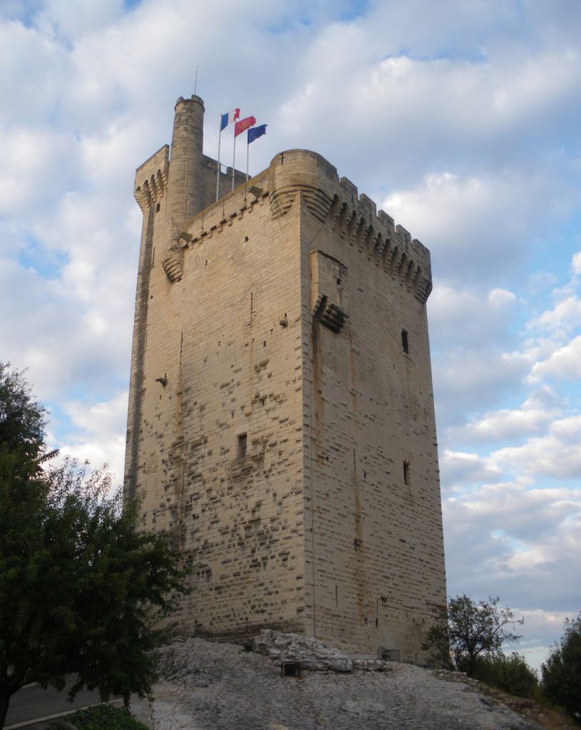
Tour Philippe-le-Bel (English: Tower of Philip the Fair) is a medieval tower in Villeneuve-lès-Avignon which marked the French terminus of the Saint-Bénézet Bridge across the Rhone between the Kingdom of France and Papal territory of Avignon. It is named after the French king Philippe-le-Bel (Philip IV "the Fair") who was responsible for its construction. A tower with only two storeys was completed in 1302. In spite of protests from the Count of Provence and the population of Avignon, Philippe-le-Bel pressed ahead and built a gatehouse at the end of the bridge. The tower and gatehouse formed part of a fortress with a curtain wall that enclosed several buildings including a chapel and a residence for the châtelain. A third storey was added to the tower in the middle of the 14th century. The Saint-Bénézet Bridge was abandoned in 1669 and the fortress then ceased to serve any useful function. The French crown continued to pay for repairs, but after the French Revolution the buildings were abandoned and allowed to fall into ruins. In 1822 the town of Villeneuve-lès-Avignon decided to demolish all of the fortress except the present tower. It was listed as a Monument historique in 1862 and is now open to the public.
Show more
Sun and Moon
Mon
Tue
Wed
Thu
Fri
Sat
Sun
May 2022
Date and time
00:00
06:00
12:00
18:00
Today
--
--
Sunrise
--
Sunset
--
Moonrise
--
Moonset
Phase
🌔 Waxing Gibbous
The perfect light time for beautiful photos:
--
Sunrise
--
Sunset
PeakVisor app
Get the app on your smartphone
New Panorama Tools
Trace location on the map
Measure distances
All the instruments are available in the context menu as well.
We use GPS information embedded into the photo when it is available.
3D mountains overlay
Adjust mountain panorama to perfectly match your photos because recorded by camera photo position might be imprecise.
Move tool
Rotate tool
Zoom
More customization
Choose which peak labels should make into the final photo and what photo title should be.
Next
Photo Location
Satellitte
Flat map
Relief map
Latitude
Longitude
Altitude
OR
Latitude
°'''
Longitude
°'''
Apply
Register Peak
Peak Name
Latitude
Longitude
Altitude
Register
Teleport
PeakVisor
This 3D model of Sagarmatha National Park in Nepal was made using the PeakVisor app topographic data. The mobile app features higher precision models worldwide, more topographic details, and works offline. Download PeakVisor maps today.
Download OBJ model
PeakVisor
The download should start shortly. If you find it useful please consider supporting the PeakVisor app.
PeakVisor for iOS and Android
Be a superhero of outdoor navigation with state-of-the-art 3D maps and mountain identification in the palm of your hand!