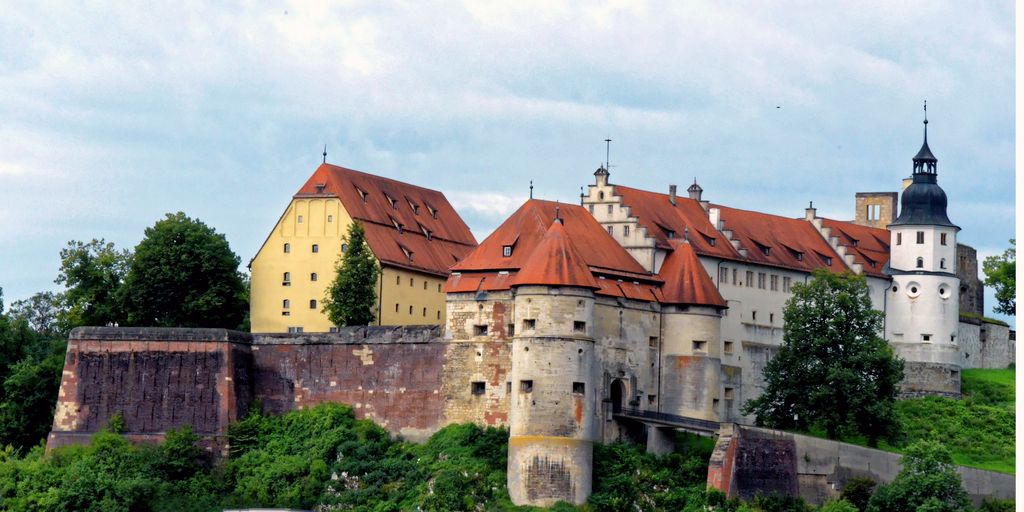
Hellenstein Castle is located 70 meters (230 ft) above the city of Heidenheim an der Brenz in eastern Baden-Württemberg, Germany. It was once the home of the Lords of Hellenstein. The castle was first built during the 12th century by the Hellenstein family. In 1273 the castle passed out of the control of the Hellensteins and had several owners before coming under the control of the Dukes of Württemberg. On August 5, 1530 the old castle burned to the ground and was rebuilt during the mid-16th century. At the end of the century it was expanded on its eastern flank to create a new castle. During the 17th and early 18th century the castle was at its peak as a symbol of the Württemberg dukes. Around 1762 the family could no longer maintain the castle and it began to fall into disrepair. Eventually some of the stones were sold off as building material. In 1901 the former castle church was acquired by the Folk and Ancient History Society of Heidenheim as a museum. The museum expanded throughout the first half of the 20th century, until in 1956 the entire castle was rebuilt as a museum. In 1993 the city of Heidenheim took over the museum from the Society. Today the castle contains several museums which are open from March 15 until November 15 Tuesday through Sunday.
We use GPS information embedded into the photo when it is available.
3D mountains overlay
Adjust mountain panorama to perfectly match your photos because recorded by camera photo position might be imprecise.
Move tool
Rotate tool
Zoom
More customization
Choose which peak labels should make into the final photo and what photo title should be.
Next
Photo Location
Satellitte
Flat map
Relief map
Latitude
Longitude
Altitude
OR
Latitude
°'''
Longitude
°'''
Apply
Register Peak
Peak Name
Latitude
Longitude
Altitude
Register
Teleport
PeakVisor
This 3D model of Sagarmatha National Park in Nepal was made using the PeakVisor app topographic data. The mobile app features higher precision models worldwide, more topographic details, and works offline. Download PeakVisor maps today.
Download OBJ model
PeakVisor
The download should start shortly. If you find it useful please consider supporting the PeakVisor app.
PeakVisor for iOS and Android
Be a superhero of outdoor navigation with state-of-the-art 3D maps and mountain identification in the palm of your hand!