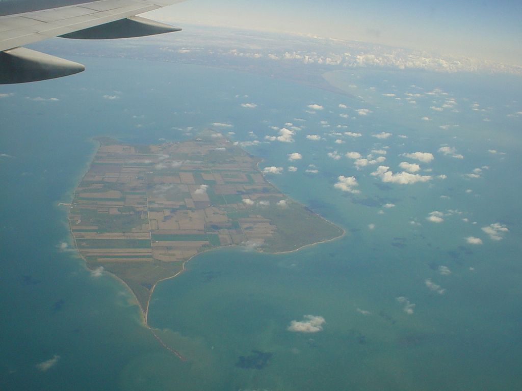
Pelee Island is an island in the Canadian province of Ontario. It is located in the western half of Lake Erie. At 42 km2 (16 sq mi), Pelee Island is the largest island in Lake Erie and the southernmost populated point in Canada. An Ontario Historical Plaque was erected by the province to commemorate the development of Pelee Island's role in Ontario's heritage. Nearby Middle Island is the southernmost point of land in Canada. Due to its southerly location and the moderating effect of Lake Erie, it has a slightly milder climate than inland areas. Its climate is one of the mildest in Canada, and the island has been used for vineyards and wine making since 1860, though local wine making died out in the early twentieth century and was restarted in the 1980s by the Pelee Island Winery. The island is an agricultural-based community, which grows about 2,000 hectares (5,000 acres) of soybeans, about 400 hectares (1,000 acres) of wheat, 200 hectares (500 acres) of grapes, and a few hectares of specialty corn. The island is connected to the Canadian mainland and the United States by ferry service. It is a part of an important flyway for migrating birds between Ohio, the Lake Erie islands and Point Pelee. For many years, the island has hosted a fall pheasant hunt which attracts hunters from Canada, the United States and many other countries. The pheasant hunt brings tourist dollars to Pelee at a time of year when virtually no other activities are available, thus generating important revenue in the offseason.
Show more
Sun and Moon
Mon
Tue
Wed
Thu
Fri
Sat
Sun
May 2022
Date and time
00:00
06:00
12:00
18:00
Today
--
--
Sunrise
--
Sunset
--
Moonrise
--
Moonset
Phase
🌔 Waxing Gibbous
The perfect light time for beautiful photos:
--
Sunrise
--
Sunset
PeakVisor app
Get the app on your smartphone
New Panorama Tools
Trace location on the map
Measure distances
All the instruments are available in the context menu as well.
We use GPS information embedded into the photo when it is available.
3D mountains overlay
Adjust mountain panorama to perfectly match your photos because recorded by camera photo position might be imprecise.
Move tool
Rotate tool
Zoom
More customization
Choose which peak labels should make into the final photo and what photo title should be.
Next
Photo Location
Satellitte
Flat map
Relief map
Latitude
Longitude
Altitude
OR
Latitude
°'''
Longitude
°'''
Apply
Register Peak
Peak Name
Latitude
Longitude
Altitude
Register
Teleport
PeakVisor
This 3D model of Sagarmatha National Park in Nepal was made using the PeakVisor app topographic data. The mobile app features higher precision models worldwide, more topographic details, and works offline. Download PeakVisor maps today.
Download OBJ model
PeakVisor
The download should start shortly. If you find it useful please consider supporting the PeakVisor app.
PeakVisor for iOS and Android
Be a superhero of outdoor navigation with state-of-the-art 3D maps and mountain identification in the palm of your hand!


.jpg)


