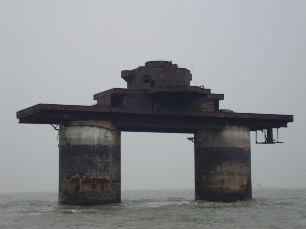
The Maunsell Forts are towers built in the Thames and Mersey estuaries during the Second World War to help defend the United Kingdom. They were operated as army and navy forts, and named for their designer, Guy Maunsell. The forts were decommissioned during the late 1950s and later used for other activities including pirate radio broadcasting. One of the forts is managed by the unrecognised Principality of Sealand; boats visit the remaining forts occasionally, and a consortium named Project Redsands is planning to conserve the fort situated at Red Sands. The aesthetic attraction of the Maunsell forts has been considered to be associated with the aesthetics of decay, transience and nostalgia. During the summers of 2007 and 2008 Red Sands Radio, a station commemorating the pirate radio stations of the 1960s, operated from the Red Sands fort on 28-day Restricted Service Licences. The fort was subsequently declared unsafe, and Red Sands Radio has moved its operations ashore to Whitstable. Forts had been built in river mouths and similar locations to defend against ships, such as the Grain Tower Battery at the mouth of the Medway dating from 1855, Plymouth Breakwater Fort, completed 1865, the four Spithead Forts: Horse Sand Fort, No Mans Land and St Helens Forts which were built 1865–1880 and Spitbank Fort, built during the 1880s, the Humber Forts on Bull & Haile Sands, completed in late 1919, and the Nab Tower, intended as part of a World War I anti-submarine defense but only set in place in 1920.
Show more
Sun and Moon
Mon
Tue
Wed
Thu
Fri
Sat
Sun
May 2022
Date and time
00:00
06:00
12:00
18:00
Today
--
--
Sunrise
--
Sunset
--
Moonrise
--
Moonset
Phase
🌔 Waxing Gibbous
The perfect light time for beautiful photos:
--
Sunrise
--
Sunset
PeakVisor app
Get the app on your smartphone
New Panorama Tools
Trace location on the map
Measure distances
All the instruments are available in the context menu as well.
Loading Maunsell Navy Fort "Knock John Tower" panorama
We use GPS information embedded into the photo when it is available.
3D mountains overlay
Adjust mountain panorama to perfectly match your photos because recorded by camera photo position might be imprecise.
Move tool
Rotate tool
Zoom
More customization
Choose which peak labels should make into the final photo and what photo title should be.
Next
Photo Location
Satellitte
Flat map
Relief map
Latitude
Longitude
Altitude
OR
Latitude
°'''
Longitude
°'''
Apply
Register Peak
Peak Name
Latitude
Longitude
Altitude
Register
Teleport
PeakVisor
This 3D model of Sagarmatha National Park in Nepal was made using the PeakVisor app topographic data. The mobile app features higher precision models worldwide, more topographic details, and works offline. Download PeakVisor maps today.
Download OBJ model
PeakVisor
The download should start shortly. If you find it useful please consider supporting the PeakVisor app.
PeakVisor for iOS and Android
Be a superhero of outdoor navigation with state-of-the-art 3D maps and mountain identification in the palm of your hand!