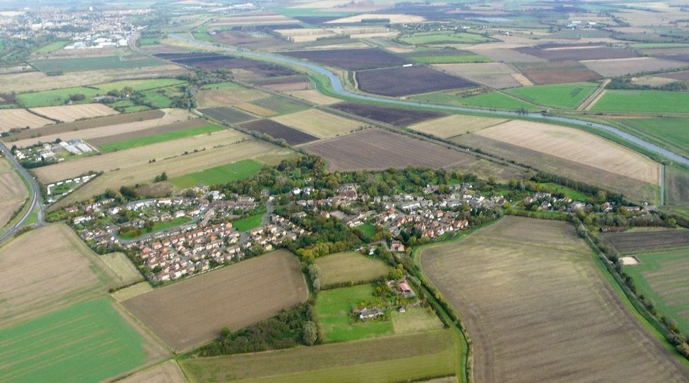
Little Thetford is a small village in the civil parish of Thetford, 3 miles (5 km) south of Ely in Cambridgeshire, England, about 76 miles (122 km) by road from London. The village is built on a boulder clay island surrounded by flat fenland countryside, typical of settlements in this part of the East of England. During the Mesolithic era, the fenland basin was mostly dry and forested, although subject to salt and fresh water incursions. The marshes and meres of this fenland may therefore have been difficult to occupy, other than seasonally, but there is evidence of human settlement on the island since the late Neolithic Age; a Bronze Age causeway linked the village with the nearby Barway, to the south-east. An investigation, prior to a 1995 development in the village, discovered a farm and large tile-kiln of Romano-British origin; further investigations uncovered an earlier settlement of the Pre-Roman Iron Age. The Roman road Akeman Street passed through the north-west corner of the parish, and the lost 7th century Anglo-Saxon village of Cratendune may be nearby. The 10th-century Old English name, lȳtel Thiutforda, suggests a ford across the nearby River Great Ouse, which today forms most of the village's eastern boundary. In 1007, an Anglo-Saxon noblewoman named Ælfwaru granted her lands in Cambridgeshire and Norfolk, including the "land at Thetford and the fisheries around those marshes", to the abbots of Ely Abbey; the village was still listed as a fishery in the Domesday Book, 79 years later. Pasture farming, and harvesting of reeds, peat, and rushes were the other dominant activities of the time. The draining of the land, which began in the 17th century, enabled arable farming activity that continues to this day. During the late 19th century, coprolite, a phosphate-rich fossil used as a fertiliser, was mined in shallow pits around the village. Little Thetford resisted the parliamentary Inclosure Acts of William IV for seven years, which may have led to the strong Baptist following amongst the poor of the village. About half of Little Thetford was eventually enclosed under the Thetford Inclosure Act of Victoria. The river flooding, which affected 30 counties in England during March 1947, caused the Great Ouse to break its banks at Little Thetford. Heavy rain following a very severe winter overwhelmed multiple rivers throughout England and eastern Wales. It was the worst flooding in over two hundred years. The dismantled Ely and St Ives Railway crossed the A10 road at Thetford corner. The Cambridge station to Ely station section of the Fen Line passes through the east of the village. Occupying an area of 2 square miles (5 km2), and with a population of 792, Little Thetford is the smallest civil parish in the ward of Stretham; notable buildings in the village date from the 14th century.
Show more
Sun and Moon
Mon
Tue
Wed
Thu
Fri
Sat
Sun
May 2022
Date and time
00:00
06:00
12:00
18:00
Today
--
--
Sunrise
--
Sunset
--
Moonrise
--
Moonset
Phase
🌔 Waxing Gibbous
The perfect light time for beautiful photos:
--
Sunrise
--
Sunset
PeakVisor app
Get the app on your smartphone
New Panorama Tools
Trace location on the map
Measure distances
All the instruments are available in the context menu as well.
We use GPS information embedded into the photo when it is available.
3D mountains overlay
Adjust mountain panorama to perfectly match your photos because recorded by camera photo position might be imprecise.
Move tool
Rotate tool
Zoom
More customization
Choose which peak labels should make into the final photo and what photo title should be.
Next
Photo Location
Satellitte
Flat map
Relief map
Latitude
Longitude
Altitude
OR
Latitude
°'''
Longitude
°'''
Apply
Register Peak
Peak Name
Latitude
Longitude
Altitude
Register
Teleport
PeakVisor
This 3D model of Sagarmatha National Park in Nepal was made using the PeakVisor app topographic data. The mobile app features higher precision models worldwide, more topographic details, and works offline. Download PeakVisor maps today.
Download OBJ model
PeakVisor
The download should start shortly. If you find it useful please consider supporting the PeakVisor app.
PeakVisor for iOS and Android
Be a superhero of outdoor navigation with state-of-the-art 3D maps and mountain identification in the palm of your hand!