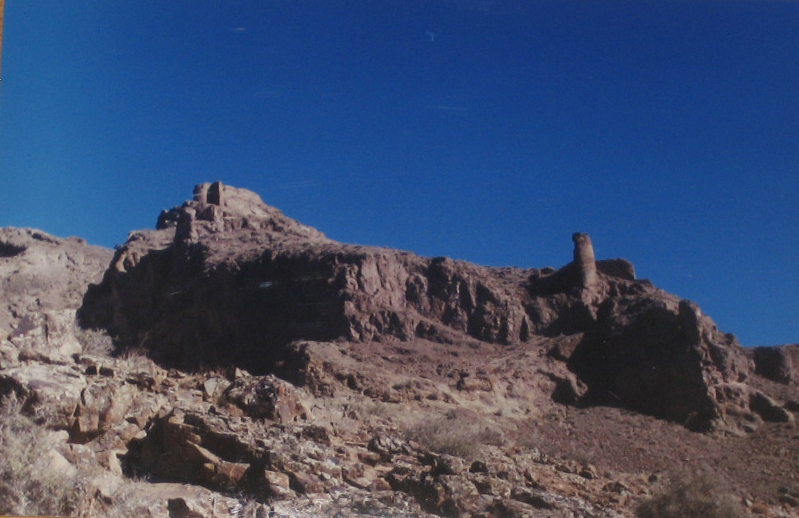
Lambsar (Persian: لمبسر, also pronounced Lamsar), Lamasar, Lambasar, Lambesar (لمبه سر) or Lomasar (لمسر) was probably the largest and the most fortified of the Ismaili castles. The fortress is located in the central Alborz mountains, south of the Caspian Sea, about 120 km from present-day Tehran, Iran. Lambsar is to the northeast of Razmian village (the central district of Rudbar e Shahrestan). Kiya Buzurg Ummid (died 1138) captured the castle from Rasamuj and rebuilt it into a major stronghold using local labour. He was appointed by Hassan-i Sabbah (died 1124) as its governor. Only ruins remain of this magnificent fortress today. Very deep valleys surrounding the fortress make it impossible to access from the East and West sides. The North and South fronts are the only possible ways to get into the fortress. Although the slope of the mountain with a difference of 150m on both levels is stretched from north to south with a length of 480m, the castle is more than 190m in width. The huge two-layered parapets made up of very large 10m high stones, along with the main building in the north of the fortress with 1.2m wide cut stone walls, wonderful water reservoirs and grain stores in the south and southeast of the castle, towers and a water supply system are among the characteristics and features left within the Lambsar fortress which intrigue visitors. In the North side of the fortress a huge building with 4 smaller extensions remain which face to the East.
We use GPS information embedded into the photo when it is available.
3D mountains overlay
Adjust mountain panorama to perfectly match your photos because recorded by camera photo position might be imprecise.
Move tool
Rotate tool
Zoom
More customization
Choose which peak labels should make into the final photo and what photo title should be.
Next
Photo Location
Satellitte
Flat map
Relief map
Latitude
Longitude
Altitude
OR
Latitude
°'''
Longitude
°'''
Apply
Register Peak
Peak Name
Latitude
Longitude
Altitude
Register
Teleport
PeakVisor
This 3D model of Sagarmatha National Park in Nepal was made using the PeakVisor app topographic data. The mobile app features higher precision models worldwide, more topographic details, and works offline. Download PeakVisor maps today.
Download OBJ model
PeakVisor
The download should start shortly. If you find it useful please consider supporting the PeakVisor app.
PeakVisor for iOS and Android
Be a superhero of outdoor navigation with state-of-the-art 3D maps and mountain identification in the palm of your hand!