Scan the QR code and open PeakVisor on your phone
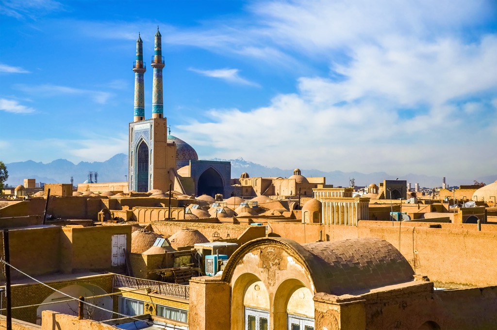
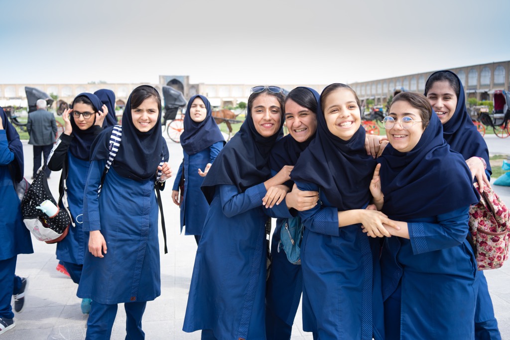
Shrouded in centuries-long mysteries, Iran is unequivocally tempting. It is one of the oldest countries in the world that used to be known by the name Persia since time immemorial. Iran has managed to keep its ethnic variety, amazing culture and fascinating traditions. It is famous for its great architecture and intricate art, historical monuments preserved from different epochs and ancient cities. Iranian cuisine and crafts are well-known beyond the country’s borders.
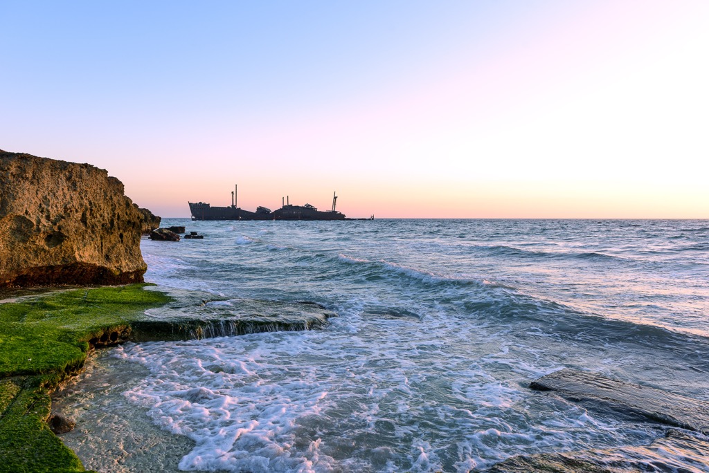
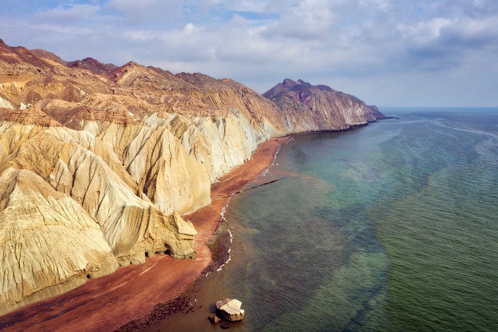
Iran can boast of unfathomably beautiful pristine nature. Here you can see majestic mountain ranges with snow-capped peaks, volcanoes with healing hot springs, ethereal deserts and long sandy seashores. There are picturesque waterfalls, mysterious caves, centuries-old forests and mango groves in Iran.
Iran is the birthplace of Zoroastrism, which was eventually replaced by Islam after the Arab conquests in the 7th century. Nowadays, the country lives by the laws of Sharia, and tourists are also required to comply with certain rules. Those travellers who respect the peculiarities of the country and are willing to comply with the local rules, will feel comfortable and derive great pleasure from visiting Iran.
Iran - what does the word mean? Where do its roots come from?
The name dates back to times immemorial, when the ancient Indo-Iranians were called "arya". The land inhabited by the ancient Persians was called "Airyanem Vaejah", which translates as "the Aryans’ land" or "the Land of the Aryans". Before 1935, the modern territory of Iran was known throughout the world as Persia. Now its name is Iran or officially - the Islamic Republic of Iran. Tehran is the capital of modern Iran. Its population is 85,582,863 people, as of 2021.
Iran is located in southwestern Asia at the crossroads of the Middle East and Central Asia. It is washed by the Caspian Sea in the north, and the Gulf of Oman and the Persian Gulf in the south. Landwise, its neighbours are Iraq, Turkey, Armenia, and Azerbaijan in the west and Turkmenistan, Afghanistan, and Pakistan in the east. The country shares the Caspian Sea with Russia and Kazakhstan, the Persian Gulf with Iraq, Kuwait, Saudi Arabia, Qatar, Bahrain and the UAE, and the Gulf of Oman with Oman.
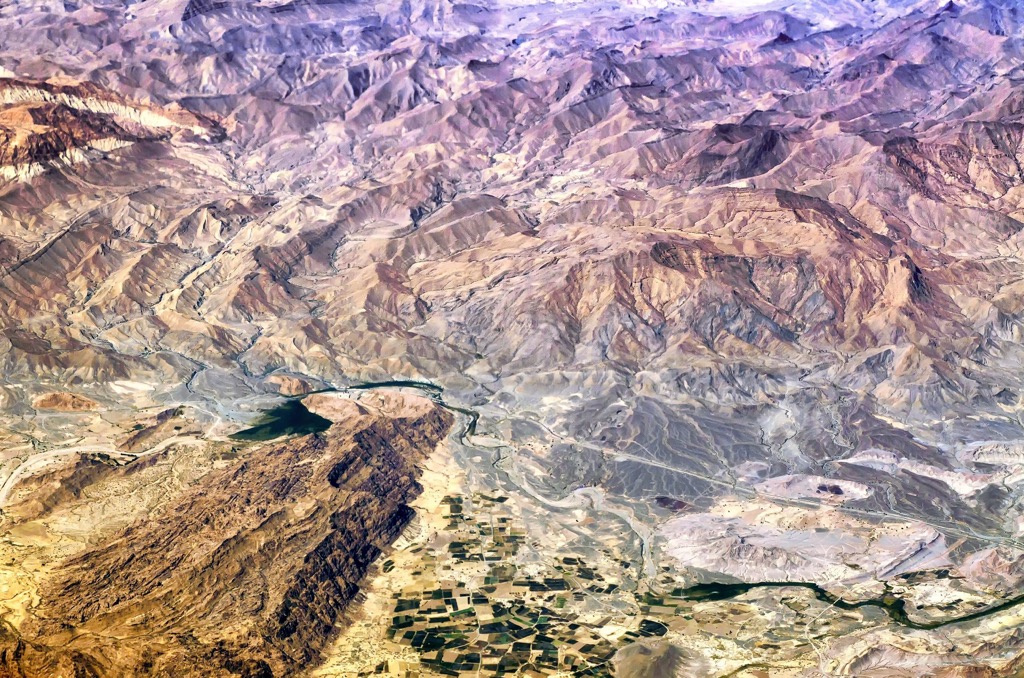
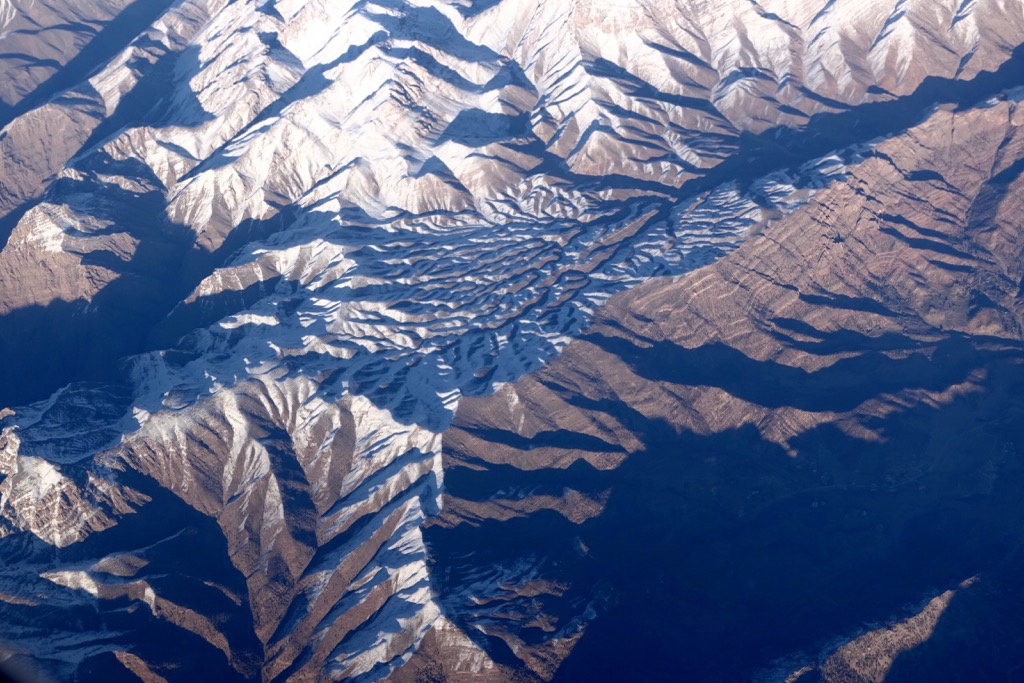
The country has an area of 1,648,000 sq. km. This roughly compares to the size of five Germanies. There are about 41788 named mountains in Iran. Most of the country is located at an altitude of 900m a.s.l. and above.
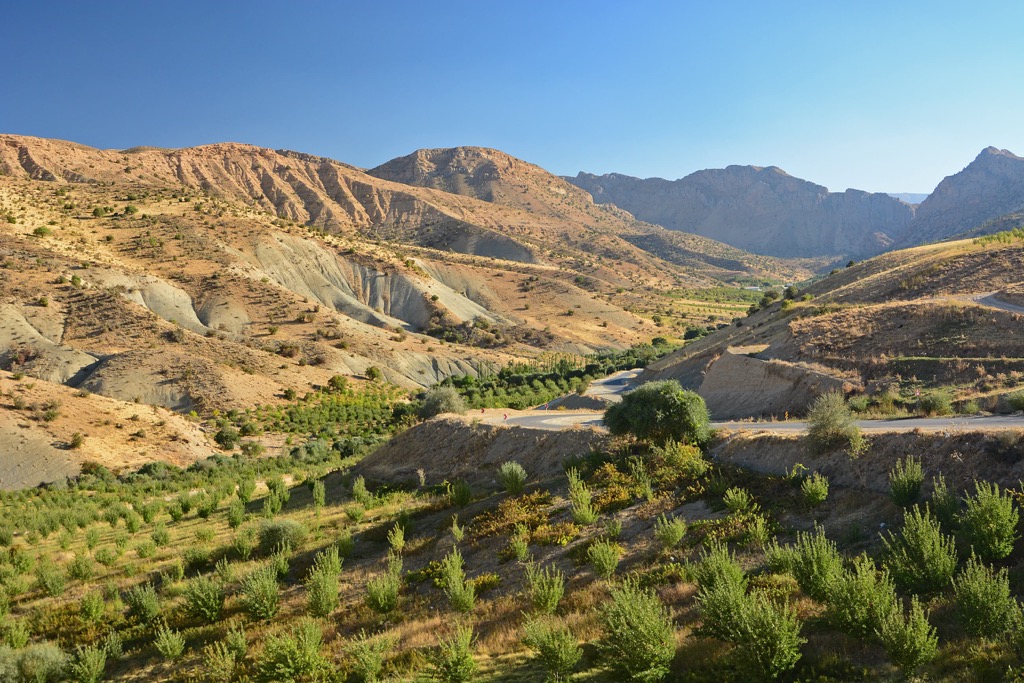
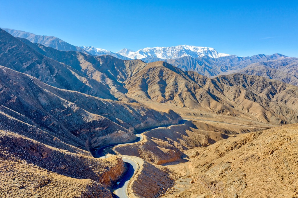
Geographically, Iran is mostly occupied by the Inner Iranian Plateau. The average height of the Inner Iranian Plateau is 1,200m. It consists of mountain ranges, rather large plateaus and intermountain basins. The Makran Mountains rise in the south, the Zagros Mountains are in the west, the Elburz (also spelt as Alborz, Albourz, Alburz, or Elburs) Mountain System are found in the north, and the East Iranian Mountains occupy the east of the country.
In Iranian Azerbaijan Provinces - a region in northwestern Iran, it has West and East Azerbaijan ostans - districts - the mountains are less dissected than the Elburz and the Zagros. They are located between the Talysh Mountains and the Kurdistan Mountains, as part of the Armenian Highlands. Rising to a height of 2,130-3,050 m, the mountains in Iranian Azerbaijan quite steeply end at the valley of the Araks (Arax) River flowing along the border with Armenia and Azerbaijan.
The well-known intermountain hollows are the Khoy-Merend Hollow, the Urmia Hollow with a salt lake, and the Karasu River Valley. Here the largest ranges include the Karadag, Sebelan, Mishudag, Bozkush, and Heremdag Ranges.
Desert and semi-desert interior plateaus, the so-called drainless depressions, are enclosed by mountain chains.
Among the characteristic forms of relief there are dry river channels (wadi), as well as sand dunes. Significant areas are occupied by stony deserts (desht) which are devoid of any vegetation. The lowest parts of the plateaus are occupied by temporary and permanent lakes. The most extensive depressions are occupied by the Desht-Lut and Desht-Kevir (Great Salt Desert) deserts. In winter, due to rains and increased precipitation, shallow lakes appear in the deserts.
Mountains separate the plains from the inner-country plateaus. There are narrow coastal plains along the seashores. In the north of the country, there are two more small plains: the steppe strip south of the Araks River and the Gorgan Steppe.
Iran is rich in mineral resources. The country has the world's third-largest reserves of oil and the second-largest deposits of natural gas, large deposits of iron ore, coal, zinc, and manganese.
Arid climate and the mountainous terrain contribute to the fact that there are no major rivers in Iran. There is only one navigable river - the Karoun. Other important but not navigable rivers include the Zayande, the Karhe, and the Dez. Many small rivers and rivulets, which are also quite short, can be found in the north of Iran. Running down from the Elburz, they flow into the Caspian Sea. In central Iran, rivers are full only when the snow melts in the mountains, and then they dry up during the hot season.
The largest lake of the country is Urmia Lake. It is one of the few reservoirs where water remains even in the summer during the hottest periods. However, the lake is so salty that no living organisms are found in it. There are other lakes in Iran: the Lar, Saveh, Bakhtagan, Neyriz, Gawhouni, Parishan, Neor, etc. Freshwater lakes are located in Elburz, north of Tehran.
Apart from droughts, Iran is experiencing groundwater depletion due to over-pumping of water resources. This leads to land subsidence. Massive ground subsidence has been registered in Tehran and is now considered to pose a serious threat to the city. The National Disaster Management Organisation is trying to slow down this process by developing appropriate measures.
The vegetation cover in Iran depends on the precipitation and the moisture content of the area, as well as on the human economic activity, most of all the vegetation is affected by agriculture and cattle grazing.
In the recent past, the central and northern areas of the Zagros Mountains were wrapped with a green blanket of oak forests. Unfortunately, nowadays they have almost vanished due to active indiscriminate deforestation and grazing of goats and sheep. Gradually, the oaks began to be surrounded by shrubs. As you move to the south, where there is even less rainfall, the oaks are replaced by a sparse forest of almond, pistachio and cherry plum (Prunus divaricata or P. cerasifera called alycha).
The slopes of the Elburz Range are the most humidified in the north, and up to a height of 2,500m they are covered with broad-leaved forests with thick crowns. Oak, beech, hornbeam, maple, Persian parrot tree (or ironwood, as it is also called), ash, elm, sycamore, plum, and walnut trees prevail here. The northern slopes of the Elburz Mountains are also covered with trees. There are small forests near Halhal, in Nahar Khoran and in southern Ardabil. The rest of the mountainous areas cannot boast such lush woody vegetation. There the trees are found quite rarely and only in more humid places - along the rivers banks in the valleys between the mountains.
Steppe and semi-desert plants are characteristic of low mountains. The steppes of Iran are filled with wormwood, cereals, and astragalus. Sometimes you can see areas of shrub thickets. Deserts are characterised by camel's thorn, saxaul, tamarix, broom sedge (Aristida), saltwort, and aloe.
Swamp and riparian vegetation predominates in the river valleys. On the coast of the Persian Gulf, you can see mangroves. And the Caspian Sea coast is occasionally inhabited by impenetrable subtropical forests, the trees of which are overgrown with vines.
As for the areas of the inner plateaus, there is almost no vegetation cover due to lack of moisture and high soil salinization. Areas of quicksand are completely barren.
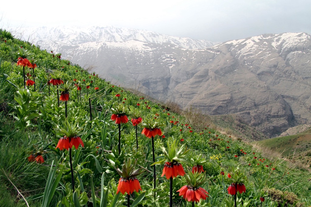
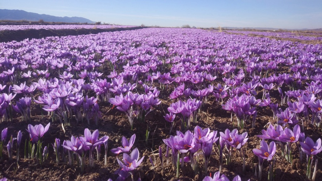
In total, about 2,500 plants have been found in Iran, but only a small number has been studied. Among them are such interesting species as fritillaria imperialis (Fritillaria persica), Iranian saffron (crocus gilanicus) and others.
Fritillaria Imperialis is popularly called the weeping tulip. It is an herbaceous plant that looks like an upside-down tulip. It is called a weeping plant because large droplets of flower sap that look like tears emerge from the base of the bowl.
Saffron in Iran is more than just a plant. It is one of the most important species in the country with high export value. It is sometimes called the "Iranian red gold", 90% of world saffron is grown in Iran. It grows more in tropical regions and can be found in Gilan and Hamedan. Saffron blooms and is harvested in autumn. A large number of its medicinal properties have been known since ancient times. Saffron is one of the most expensive spices. Nowadays, this plant is used mainly in cooking and medicine.
Saffron has a strong peculiar aroma and a bitter spicy taste. Saffron stigmas are used for colouring and flavouring confectionery and meat products in cooking, as well as in the production of cheese, sausages and liqueurs.
As a spice, saffron is used in very small quantities. In the Middle East, Central Asia and Southern Europe, it occupies an important place in the preparation of rice (pilaf, bozbash, paella) and peas (piti). Saffron is added as a spice to clear soups in the preparation of lamb, fish and cauliflower soups, broths. Along with its spicy properties, saffron also has a preservative effect. Food cooked with saffron can be preserved for several days.
Understandably, due to saffron scarcity and high price, there are some substitutes. Instead of saffron, cheaper bright orange spices such as turmeric and safflower are often used. In the markets, a less fastidious customer may be sold safflower, which has a much less pronounced flavour. It is easy to Identify real saffron: just two strands of saffron will stain three litres of water a bright yellow colour. Turmeric is also sometimes passed off as ground saffron, although it has no saffron aroma; its distinguishing feature is a yellowish hue instead of red.
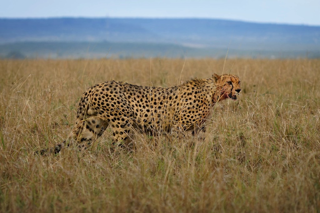
The animal world of Iran is diverse. Ungulates are widespread: Iranian doe, mountain sheep, goitered and common gazelle, ibex, urial, kulan, wild boar, mouflon, and camel. There are also found such predators as cheetah, leopard, wolf, manul and reed cat, jackal, caracal, striped hyena, and mongoose.
In the mountains live polar bear and brown bear, Persian squirrel, porcupine. The Elburz is home to mammal species not found anywhere else - the bighorn sheep (black-bearded and white-bearded). There is also a large number of rodents and birds - grey francolin, ruffed bustard, partridge, Caspian snowcock, grouse, peck, white stork, little bustard, nuthatch, buzzard, grey crane, etc. Birds have come to love the shores of the Caspian Sea, as well as the Persian Gulf. Here, you can see flamingos, sandpipers, pelicans, ducks, geese, marbled murrelets, etc. Many of them spend winter in Iran.
The waters of the Persian Gulf and the Caspian Sea are abundant with valuable species of commercial fish.
The fauna of reptiles is also rich (about 200 species)б you can see marsh crocodiles, found in the floodplain of the Serbaz River in Balochistan and green sea turtles in the waters of the Persian Gulf, etc.
The marsh crocodile (or maghera) is revered and treated with special reverence by the locals in the southeastern regions of Iran. They even help crocodiles get to water during particularly dry periods when rivers are excessively drained, leaving these reptiles without water. The Iranians call them "gandu."
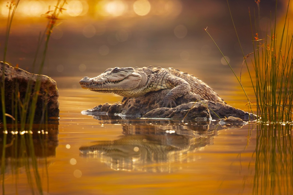
By the standards of crocodiles, the size of Iranian marsh crocodiles is average. Males reach 3.5m in length, females are usually 2.45 m. They move on land at a speed of up to 12 km/h, whereas in the water, they can develop the speed of about 30 - 40 km/h. Unfortunately, the composition of water in Iranian water bodies deteriorates every year, primarily due to human activities. With the concentration of pesticides and herbicides in water increasing, the population of marsh crocodiles is getting smaller every year. In order to conserve this species of reptile in Iran, there are even courses for locals to teach them how to take care of marsh crocodiles and how to deal with them properly.
Most of the country has a tropical desert climate. Dryness, heat, and sharp fluctuations in temperature are typical. A subtropical continental climate prevails only in the northern part of the country, along the coast of the Caspian Sea. The entire territory of Iran, except for the Caspian coast and the coastal lowlands in the south, is characterised by harsh winters. Only the highlands of the Zagros and the Caspian Sea coast receive sufficient precipitation. Precipitation in the country mainly falls between November and April, and is virtually absent during the warm season.
The country is located in several climatic zones:
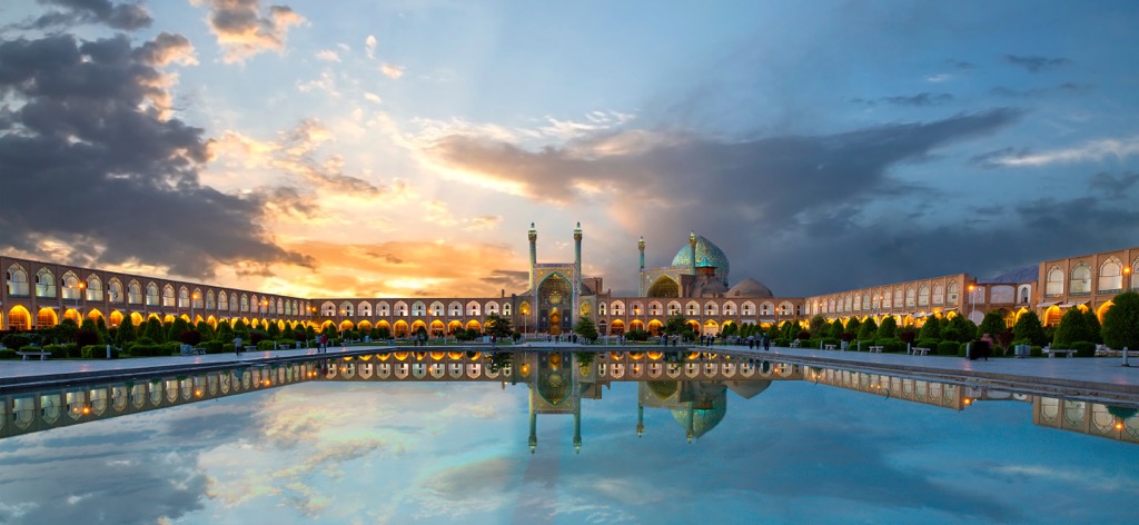
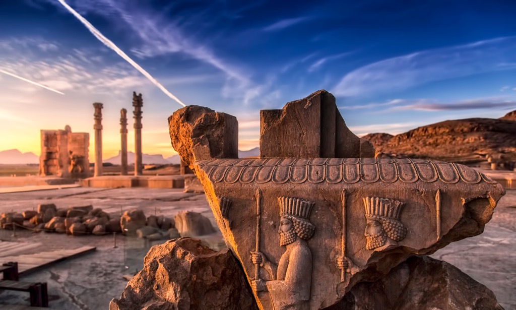
The most popular tourist attractions are concentrated on the route from Tehran towards Shiraz, following through Isfahan, Yazd, Pasargadae, as well as Persepolis. If you wish, you can fly into the country at the airport of Tehran, and fly out of Shiraz airport, so as not to make the return journey of 900 km.
In a country whose centre is covered with two vast deserts including the hottest spot on earth (70 degrees Celsius in Dasht-e Lut), the last thing you’d expect to see is a ski resort. But much to your amazement, you will find not just one but more than 20 ski resorts in Iran. You can choose a track for every taste and level of fitness, so Iran is interesting for beginners and advanced skiers, as well as freeriders. There is also a type of skiing called heliskiing or heliski, when you are delivered to a summit by a helicopter and can descend on pristine mountain slopes. Several ski resorts are located in the Elburz Mountains near the capital of Iran. Two of the most popular of these are Dizin and Shemshak.


Kish island has several diving centres. Here you can rent equipment and hire an experienced instructor. Near the island washed by the waters of the Persian Gulf, there are wonderful coral reefs with a variety of inhabitants: angel fish, groupers, snappers, spinoffs, butterfly fish, barracudas, stingrays, turtles, morays, reef sharks, hammerhead sharks, and whale sharks. Hendorabi Island, which is surrounded on all sides by coral reefs, will be of interest as well. Along Hendorabi Island coastline are steady currents, which allows you to do drift diving here.
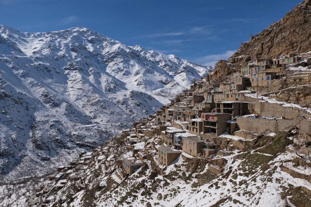
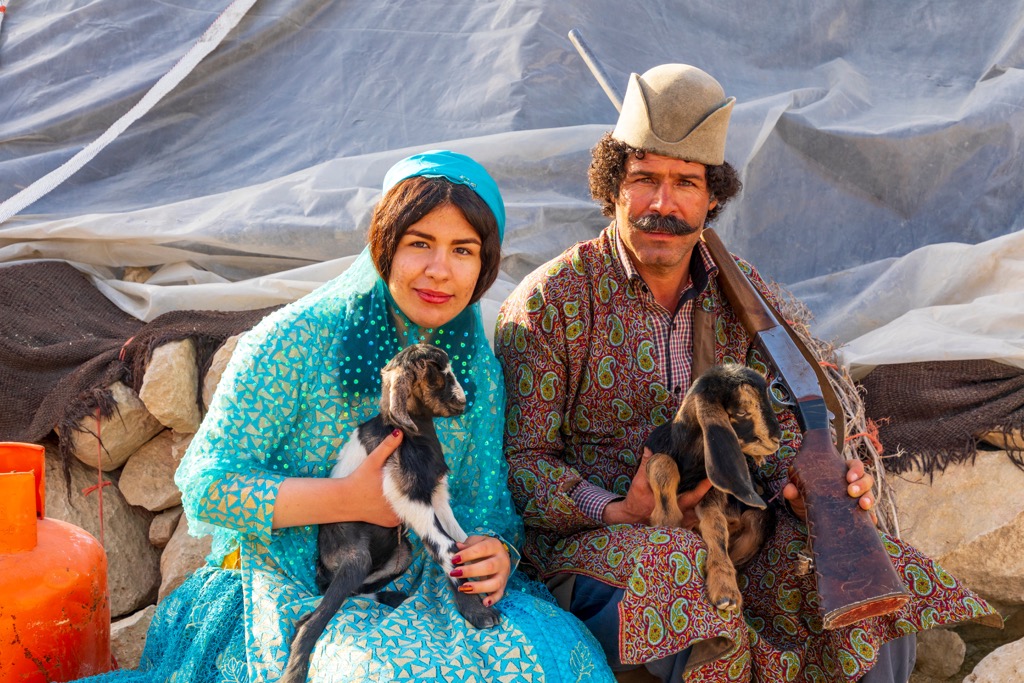
The Iranian mountains have been worshipped and considered as special sacred places for centuries. Even before Islam (in the time of Zoroastrism) many mountain peaks were considered the centres of the whole world and the dwelling place of deities as well as ancestors. Mountains were a source of water, a symbol of life and prosperity. Even today, some mountain valleys are inhabited by nomadic peoples whose life is very similar to that of their ancestors. Visiting such regions, you feel as if you have travelled back in time.
Nowadays, it is banned to worship the mountains according to Islam law.
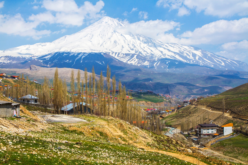
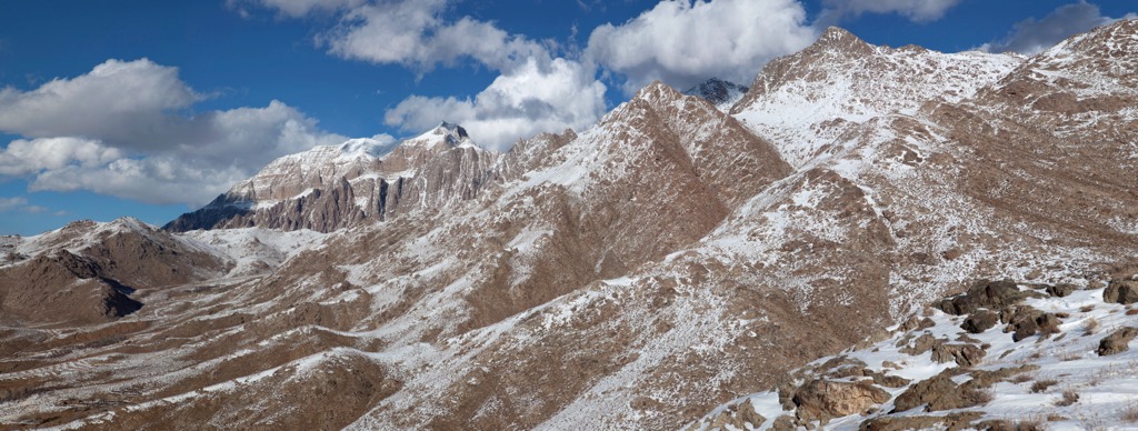
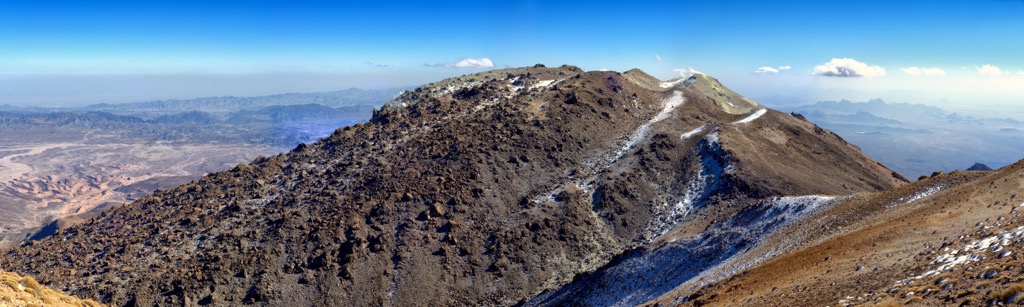
The Elburz Mountain System majestically spreads its peaks and highlands in the north of the country, near the southern coast of the Caspian Sea. The name is also spelt as Alborz, Albourz, Alburz, or Elburs. The Elburz mountain range is divided into the Western, Central, and Eastern Alborz Mountains. The Western Alborz Range (usually called the Talysh, Talesh, or Tavalesh Range or the Bogrov Dagh) runs south-southeastward almost along the western coast of the Caspian Sea. The Central Alborz (the Alborz Mountains in the strictest sense) runs from west to east along the entire southern coast of the Caspian Sea, while the Eastern Alborz Range runs in a northeasterly direction, toward the northern parts of the Khorasan region, southeast of the Caspian Sea. The Elburz Range in its central stretch includes Iran’s two highest peaks, Mount Damavand and Mount Alam. The Elburz mountain system traverses virtually all of the northernmost portions of Iran from east to west.
The word Elburz is translated from Persian as ‘a high mountain’. The outlines of Elburz have the shape of the Latin letter S, curving its ridges like a snake. By the way, some legends about the Elburz mountain range are associated with snakes. The length of the range is about 900 km. The highest point not only of Iran, but also of the entire north east is Demavend or Damavand Volcano (5,610m or 5,671m).
Other significant peaks are Alam-Kuh (4,848 m), Shah-Neshin (3,875 m), Tochal (3,964 m), Lavarak (3,560 m), Lezon-West (3,585 m), Bazarak (3,753 m), and Sar Bazarak (3,640 m).
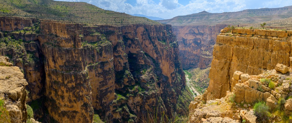
With a lattice structure with numerous ridges, the Zagros Range extends in the western part of Iran, near the city of Chalgard. It is the biggest mountain range in Iran. The Zagros Range is located on the territory of modern Iran, partially in Iraq and southeastern Turkey. More specifically, Zagros is located in the southwestern Iranian highlands. It passes through the province of Kurdistan. The highest peak is Mount Zard-e-Kuh (4,547 m).
The Zargos Range enjoys quite high seismic activity; the earthquake in Ashgabat in 1948 confirms the high seismic hazard of the area.
One of the rarest animals on our planet lives here. It is called the Zagrosian newt. It is easy to overlook this newt because its body length is only 13 centimetres. The Zagrosian newt lives exclusively in the mountains, seeking shelter at heights of over 1,500m.
The Zagros Range is famous for its salt domes that form entire glaciers. During the formation of the salt dome, the glacier is fed, these natural objects are literally filled with salt. In the Zagros, there are domes which are totally made of rock salt. It is noteworthy that glaciers are impregnated not only with salt, but also with oil, so they have a characteristic black colour.
One of the most famous mountains in the Zagros Range is Mount Derak aka Deraak, Derok (2,900m) located 20 km north-west of Shiraz. It also has other names: Kuh-e-Barfi and Mother Mountain. It is called Mother because of its appearance - from the side it resembles a lying pregnant woman. It is called Barfi because in the cold season it is covered by a snow cap (barf means snow in Persian). It is a rocky mountain and is used as a location for TV and radio turrets. There are several trails here, both for climbing and hiking.
Mount Shir-Kuh (4,075m) in the Zargos Range is located 40 km southwest of Yazd in the central part of the country, it towers majestically above the surrounding deserts. Shirkuh in Persian is formed of two words: Shir meaning milk as well as lion, and kuh or kooh meaning mountain. There are two reasons behind the etymology. The first says that most of the year this mountain is covered with snow, giving it a white colour like milk; whereas the second argument refers to the resemblance of the mountain to a lion sleeping on its paws, creating the image that in the past there actually had been a lion with a big white mane and now this magic creature is in its hibernation. To see this glorious mountain, people go to a summer village with nice weather, Deh Bala, which is always green and cool. In spite of the harsh cold weather in winter, the kind and tolerant people of Deh Bala have never left this lion alone.
The Makran (Mekran) Range is a 200km-wide folded mountain system in southern Iran, extending 480 km to the east. Farther on in the territory of Pakistan, the Makran Range changes the direction to the northeast. Some peaks rise to a height of 1,800m to 2,150m. The highest point is Mount Kukhran (2,260 m). The relief of the mountains is highly dissected.
The East Iranian Mountains run for 1,050km along the eastern border of Iran, between the Elburz and the Makran. They are lower than the Zagros Mountains, but form an atmospheric barrier on the way from Iran to Afghanistan. The average height of the mountains is 1,500m. The highest point is Taftan Volcano or Kuh-e Taftan (3,940m or 4,042m). On the mountain itselfб there are no signs of life, not even bacteria.
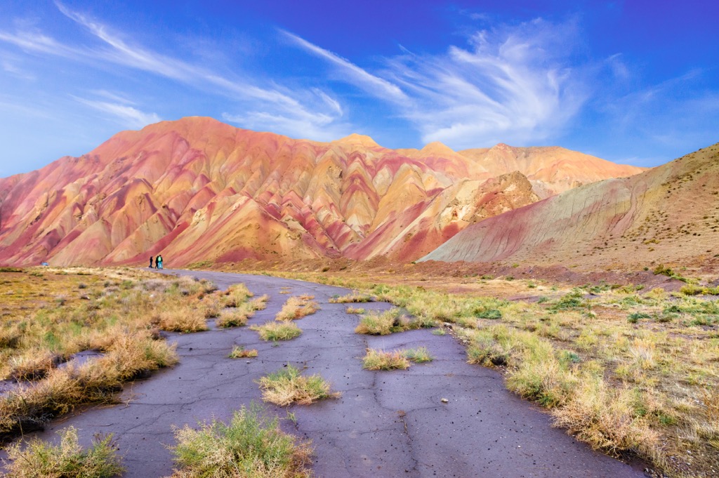
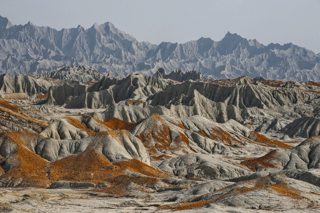
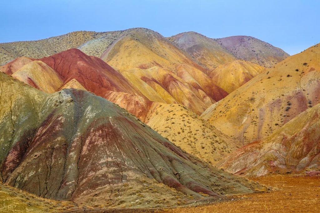
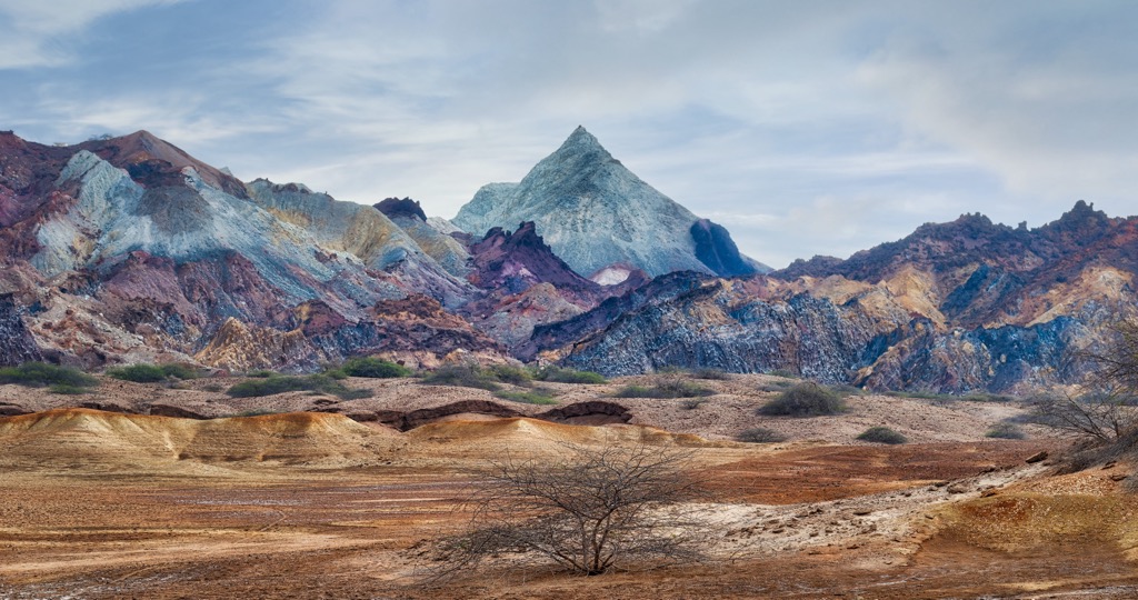
One of the most amazing natural phenomena of Iran is the Aladaglar Mountains. They are located in Mahan Shan and Zanjan (Zanjan) Provinces. You can see the rocks and hills of different colours: yellow, green, red, white and brown, rising from the ground. Sometimes the Aladaglar Mountains are called ‘the colourful mountains’. Each colour indicates the presence of the corresponding mineral. For example, red means that the mountain contains iron, whereas green indicates the presence of copper. According to scientists, the birth date of these picturesque mountains go back 15 million years ago. The people who live among the beauty of these mountains have developed some particular traditions. For example, for the holiday of Nowruz, it is customary to decorate homes with coloured soils of different shades. A walk through these fabulous places will fill you with unforgettable impressions.
Tash-Kuh is often called the blazing mountain because it is literally burning day and night. The mountain is one of the wonders of Iran. It is located in the southwest of the country, in Khuzerstan Province, 6 km from the village of Mamatin. According to geologists, the soil contains a large amount of sulphur and when gas rises from the bowels of the earth it causes the gas to ignite. Therefore, when it breaks through the surface, you can see the plumes of fire.
The mountain looks even more spectacular at night, which is when many tourists gather here.
Another interesting fact is because of the gases coming out of the mountain near Tash-Kuh, you cannot make a fire here.
Iran is located at the junction of two lithospheric plates, the movement of which periodically leads to earthquakes. The most popular extinct volcanoes are located in the northern part of the country:
These volcanoes are great places for hiking and mountain climbing. In addition, their slopes are studded with healing hot springs, beautiful lakes and waterfalls, as well as forests with a variety of wildlife. The most popular hot springs are on the northern slope of Sahand Volcano, near the village of Kandovan (particularly useful for treating kidney diseases), and springs on the slopes of Sebelan Volcano, near Sarein village (contains large amounts of sulphur compounds, most useful for bone and joint pains).
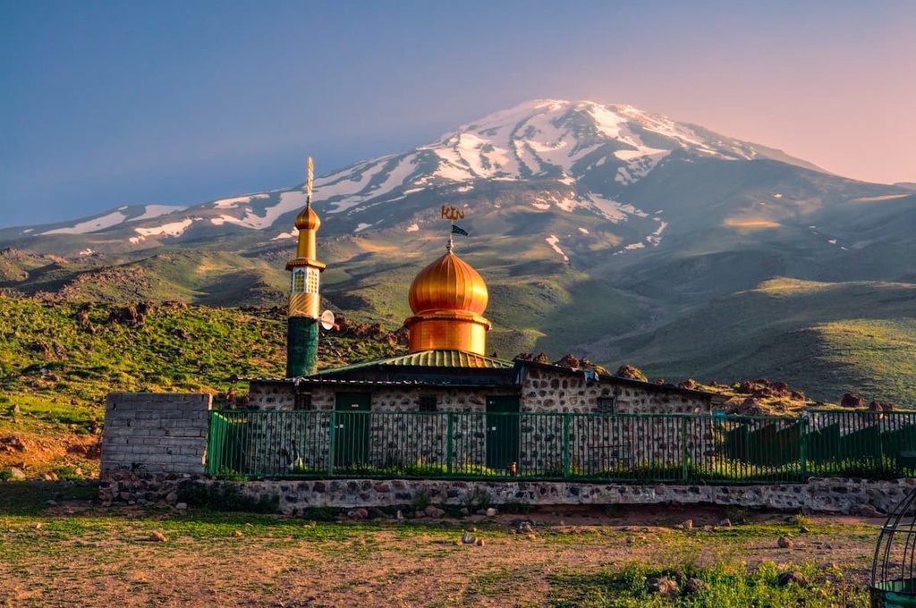
This ancient sacred mountain is now a symbol of the beauty of the Iranian mountains and the most majestic peak of the country. The word Demavend or Damavand is translated from Ancient Persian as ‘smoking’. There are many legends and poems about the mountain. According to one legend, deep in Damavand is an evil spirit called Bivarasb the monster with two snakes instead of a head. And as long as the lake located in the crater of Damavand is covered with ice, this monster will continue to be in a sleeping state and its sleep will not be disturbed.
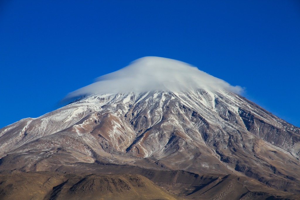
The mountain is frequently mentioned in both ancient and modern literature. It is much praised as a symbol of valour and resilience. Its symmetrical cone can be compared to such mountain peaks as Fuji (3,770m) in Japan or Ararat (5,000m) in Armenia. It is assumed that the now extinct Damavand volcano died about 100 thousand years ago. At an altitude of about 4,000 m, huge blocks and small pieces of sulphur are often found. On the funnel-shaped top there is a lake 30 metres deep, the surface of the lake is covered with ice for most of the year. Although the volcano is considered extinct, there are sources of hot gases around its crater. Therefore, you can often see puffs of thick steam. These vapours have different chemical compositions, most of them are dangerous to humans.
Should you wish to conquer Damavand, there are a large number of routes. Four are the main ones: south, north, west and east. It should be borne in mind that the springs on Damavand (usually found at about 3,500m) have sulphur in their composition. Therefore, climbers usually do not use the springs, but rather gather snow and ice at the foot of the volcano to have some fresh water. There are many glaciers on the northern as well as the northeastern side of the volcano at about 4,000m. The northeast side, also called the ‘snowy roof’, presents many challenges for climbers when traversing glacial gorges and is only accessible to professionals with extensive experience. On the southern side, there is less snow and glaciers, so it is easier to climb. From the end of April to the beginning of May, there are frequent avalanches, so it is better to refrain from climbing this majestic mountain at this time.
The dormant stratovolcano Alam-Kuh, as well as Damavand volcano, is one of the peaks of the Elburz Range. It is located in the southern part of Mazenderan Province. It is adorned by many glaciers and mountain lakes. The southern side is suitable for hiking. The northern side is a steep slope in the form of a wall reaching the height of 650 - 800m. It is one of the most interesting and technically difficult climbing routes not only in Iran. Climbing teams from Europe train on the north side. The period from mid-July to mid-August is the best time to conquer Alam-Kuh peak.
There are also active volcanoes in Iran. The active stratovolcano Taftan is located in southeastern Iran, near the provinces of Balochistan and Sistan (the nearest city is Khash). It has two peaks - Materkuh and Narkuh. Currently, the volcano has a strong fumarolic activity, you can see the gases and vapours oozing actively from the cracks (fumaroles) from several kilometres away.
Taftan and Bazman volcanoes in Iran, as well as Ko-i-Sultan volcano in Pakistan, are part of the same volcanic arc.
Qeshm is an arrow-shaped island in the Strait of Hormuz, separated from the mainland by the Khuran / Clarence Strait in the Persian Gulf. It is the largest island of Iran and the entire Persian Gulf. Qeshm Island is a wonderful place, it is called the Valley of the Stars. It is a mountainous plateau with many rocks of the most bizarre shapes. This place gets its name from a legend, according to which it arose as a result of the fall of meteorites. Qeshm Island has a Geopark (nature reserve), which is protected by UNESCO.
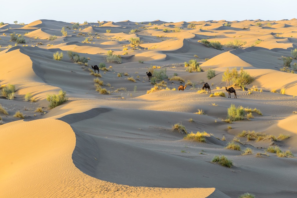
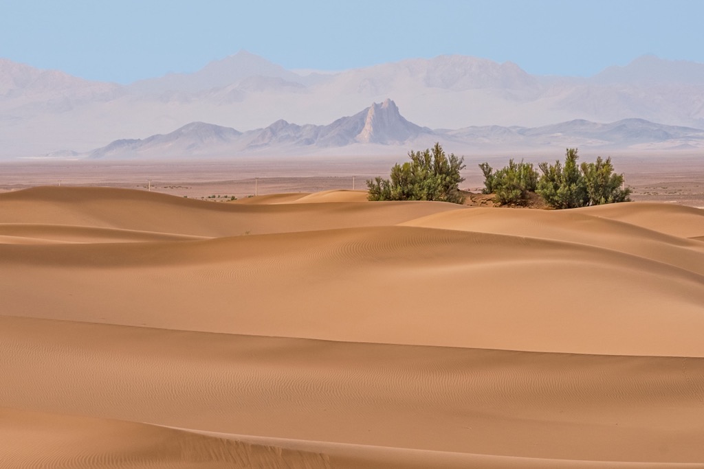
When we hear the word ‘desert’, we usually think of endless expanses of sand with occasional tall mounds of sand - barchans. However, this image certainly cannot describe all Iranian deserts. Deserts of Iran occupy about a quarter of the territory of the country and each of them has its own quirk.
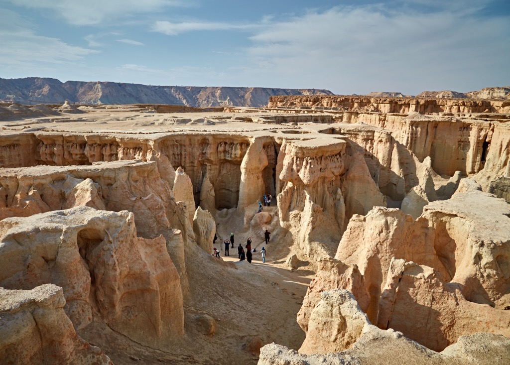
The Kalut(s) or Kalout Desert is highly likely to find a soft spot in the hearts of die-hard hikers and mountaineers. It will not only surprise you with its amazing Martian landscapes, but also provide an opportunity to climb sandy hills. From afar, these sand cliffs look like an ancient city submerged in absolute silence. The Kalut is only a 40-km drive from Shahdad. There are no plants or animals here. The desert looks particularly spectacular in the setting sun.

The largest desert in Iran is the Dasht-e-Kavir, also known as Kavir-e-Namak, literally - the salty lowlands. It is also called the Great Salt Desert and is considered one of the most lifeless deserts in the world. It is uninhabitable because of the very high temperatures and frequent storms. There are only a few oases along the edge of the desert, where clay mines produce drinking water. In the centre are sand dunes, called the Dunes of Gin. Locals are still wary of these places to this day, saying they are haunted by evil spirits.
The Dasht-e Lut Desert (or Lut Desert) is a large salt desert, it is the world’s 34th largest desert in fact. It is located in the provinces of Kerman, Sistan and Baluchestan. It also has a heterogeneous landscape. The name translates from Persian language as the Emptiness Plain. Here are the highest sand dunes in Iran, as well as the most bizarrely shaped rocks. In the spring season of short rains, small lakes and rivers form here for a short time. The salt washed away by water during the subsequent drought forms a crust of white colour. But there is also a river that does not dry up in the Dasht-e Lut. There is so much salt and minerals in it that its waters resemble a milky sour cream flowing among the sands. In 2005, in the Dasht-e Lut Desert there was registered the world temperature maximum of +70.7°C (159.26F). The temperature here is so high that there are not even bacteria present in the desert. This desert is sometimes called the hottest place on the planet.
It is most comfortable to go to the deserts in the fall and winter, when it is not so hot. However, you should keep in mind the cold nights.
The caves in Iran have their own distinctive features. Many of them have not been fully explored to this day, and the mountains continue to keep their secrets.
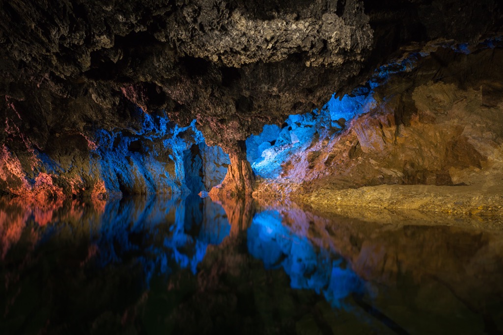
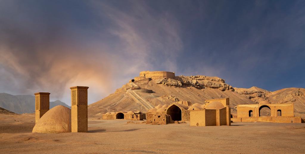
The most popular cave among tourists is the Ali-Sadr Cave, located 100 km northeast of Hamadan city. The length of the cave is 11,200m, the height of the ceilings reaches 40m. A major part of the Ali-Sadr Cave is flooded, that is why prepare for a joyful boatride. The water is so clear that the visibility reaches a depth of 10m. In addition to travelling through the underground tunnels, you can visit the cave café here.
The Ghar Parau Cave in the Zagros Range is the deepest cave in Iran. It is 751m deep. The entrance is located at an altitude of 3,100m.
The Kala Cave, located 25km from Pave (Kermanshah Province), is known for its underwater waterfalls. It is also home to rare mammals - long-eared bats. There have been many archaeological finds from the Sassanid period (coins, painted bowls and variously shaped vessels) here. The cave is about 2.7 km long but only the first 500m are accessible to tourists.
One of the most explored caves in the world is the Iranian Katala-Khor Cave. It is located 80 km from Gharmab and 120 km from Zanjan. Tourists mainly travel here by taxi since there are no public transport options. About 12 km of the cave is explored and 3 km are open to tourists. Here you can admire the stalactites and stalagmites of amazing beauty.
According to legends, in the Karaftu Cave was once a temple of Hercules. Karaftu 42 km from Tekaba, Kurdistan Province. On one of its walls, there is an inscription in Latin: "The place where Hercules lived cannot be entered by the devil". The entrance is located at a height of 9m, to which now leads a ladder, whereas previously you had to climb a rope. The cave can be reached from Tekaba by taxi.
The salt caves are also popular in Iran. They are located near the western coast of Qeshm Island. The vaults of the caves are covered with salt deposits which were formed due to the salt water streams flowing down the cave elephants. The longest salt cave in the world, the Three Nahashi Cave, is located in the same area in Namakdan. Its length is 6,200m. Walking through the winding galleries of the cave, one encounters underground rivers of salt water and various bizarrely shaped stalactites.
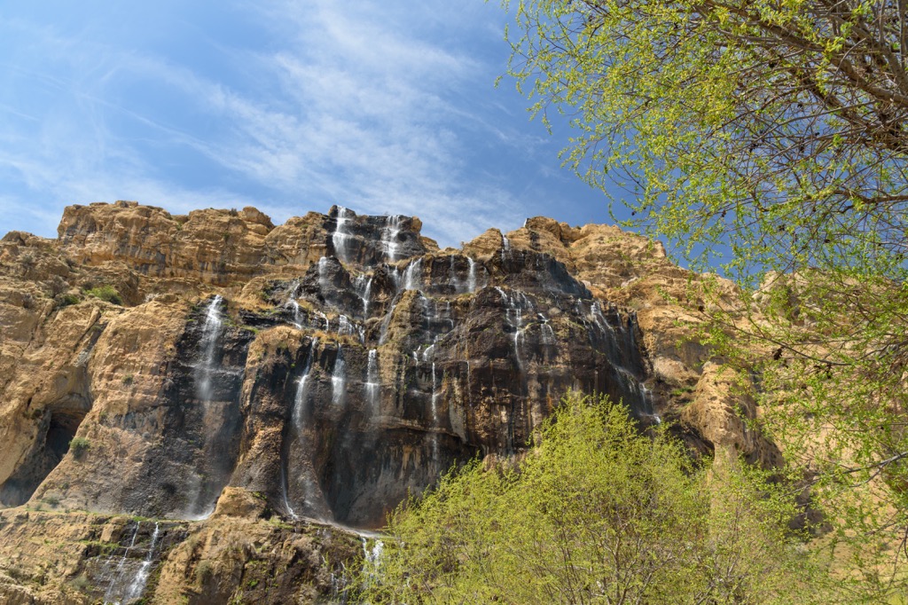
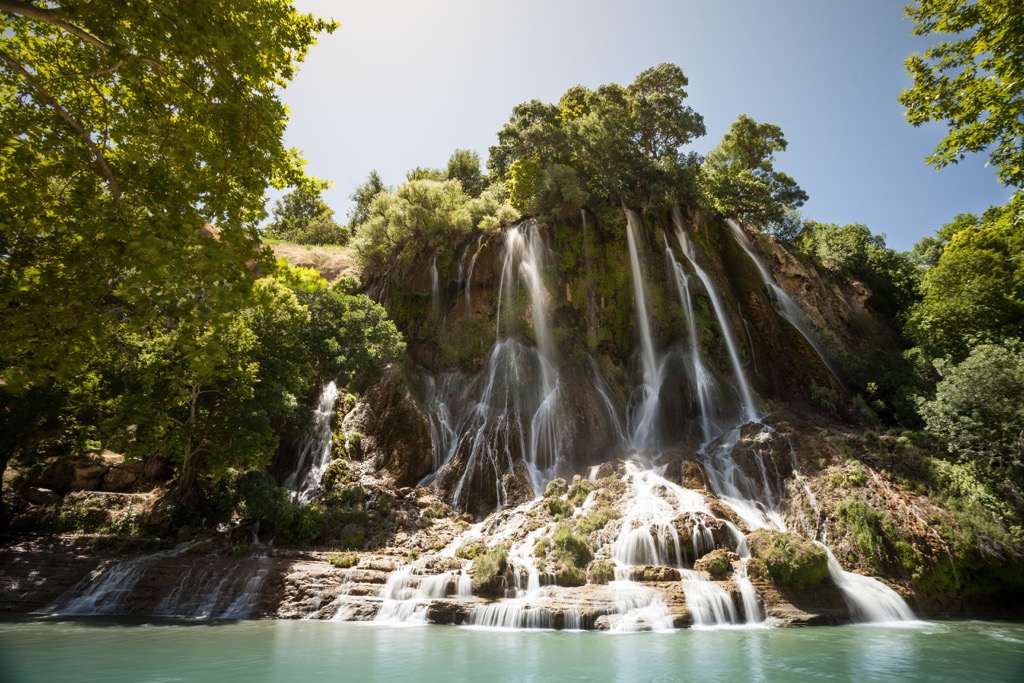
Iran is considered a low-water country, yet at the same time it has quite a handful of beautiful waterfalls - large and small. The most famous of them are listed below.
The Margoun Fall is 128 km from Shiraz in the territory of the Abshare Nature Reserve. Its height is 70m. The Margoun Fall is the most popular among tourists.
The Latun Waterfall can be found in the province of Gilan, near Astar town. The height of the waterfall is 105 m. It is the highest in Iran.
The Yaqhi or Abshar Yaqhi Waterfall in Mazandaran Provincу is 70m high. The waterfall, located at an altitude of 5,100m on the slope of Damavand Volcano, has an interesting feature. It is a waterfall of ice. In the warm season, the waterfall thaws a little: at noon, the thawed water mixed with ice and snow begins to move. By the evening, the waterfall cools down, the temperature drops below freezing again, and the water hardens into ice.
The Seven Springs Waterfall can be found in a valley with seven springs that are falling into a waterfall called Sheikh Alikhan. The Seven Springs Waterfall is located in Bakhtiari Province, near Shirabad village.
The Bishe Waterfall is in Lorestan Province in the Zagros Mountains. The province is full of lakes, rivers and waterfalls, the largest of which is the Bishe. Its height is 48m.
The Shir-Abad Waterfalls are in Golestan Province, close to Shirabad village. The Shir-Abad consists of 12 waterfalls, the highest of which has a height of 30m.
The Kharaba Deirman waterfall, also known as Asiyab Kharabe Waterfall, Kharaba Deyirman, Abshar Asiab Kharabeh, or the Ruined Mill Waterfall, is 135 km from Tabriz, the Province of East Azerbaijan. It is located 27 km from hadi shahr, the border strip of Iran and Azerbaijan and 5 km from Manjan Abad Village in East Azerbaijan, along the Marand-Julfa route. Asiab Kharabeh is a name attributed to the water spring, waterfall, river and road located in this land. The waterfall is on the territory of the Aras Geological Park. The remains of old mills that can be seen in some parts of this site. The Asiab Kharabeh Water Spring is a trough that feeds Asaib Kharabeh Waterfall, and then flows into a deep valley. The walls of the waterfall and megaliths on the right side of the valley are covered with lichens and moss and green and emerald water plants. The stone walls, the trees and the water canals resemble the traditional Iranian paintings as if they have been recreated and are moving right in front of the viewer’s eyes. It is considered the most beautiful in the Eastern Azerbaijan.
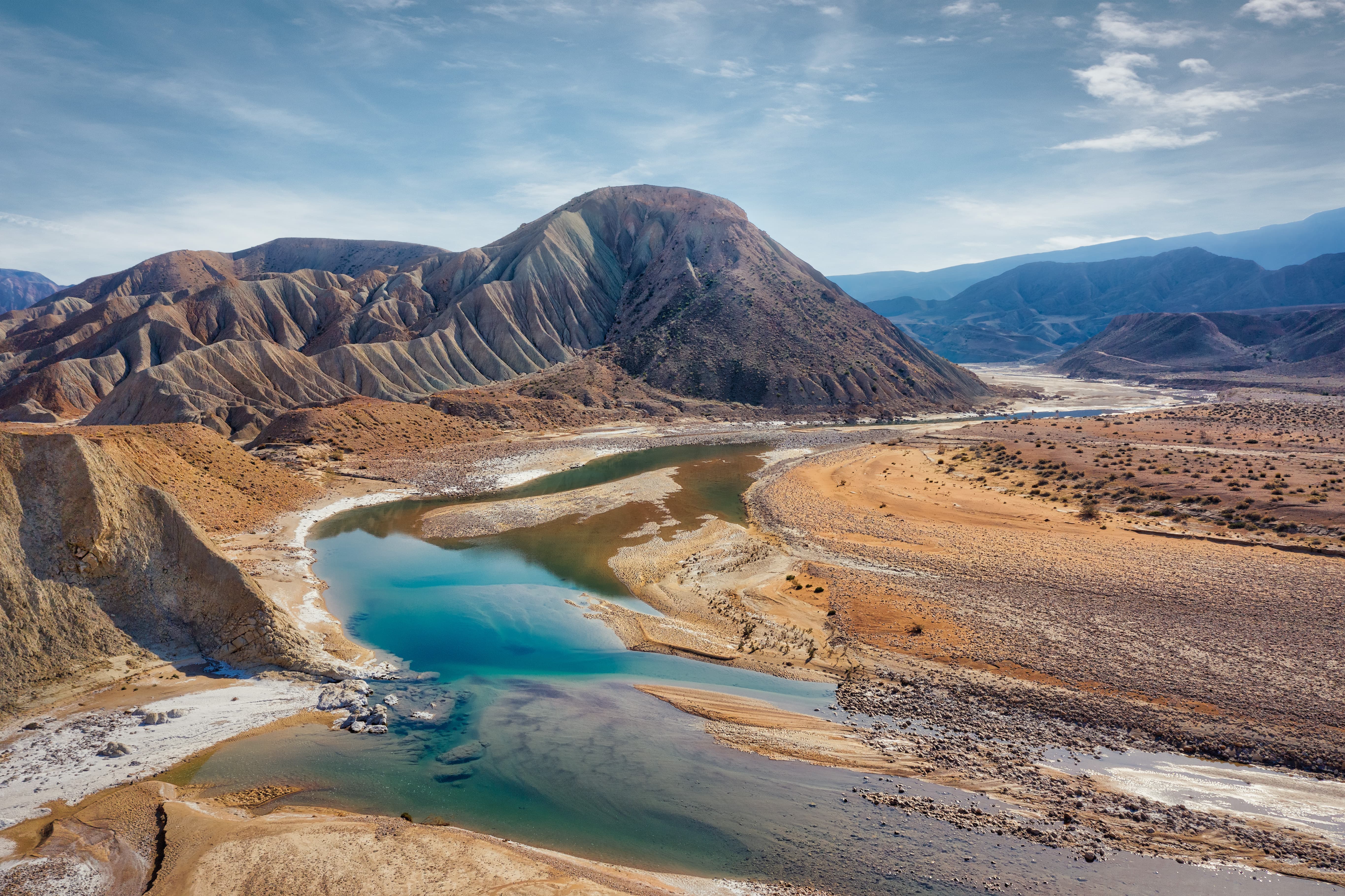
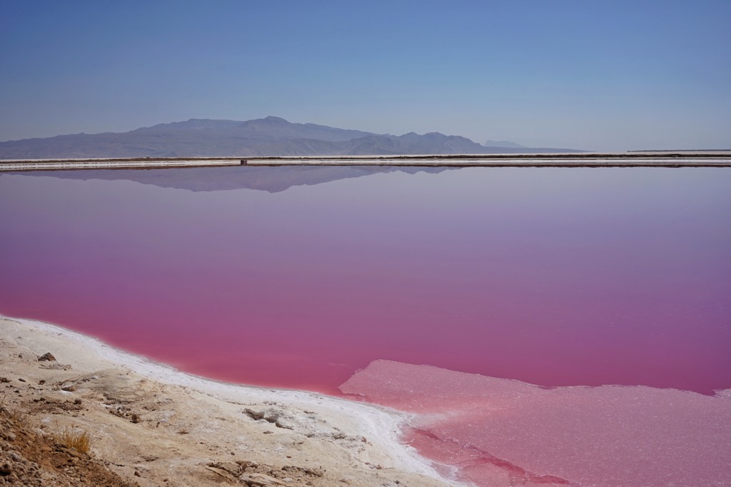
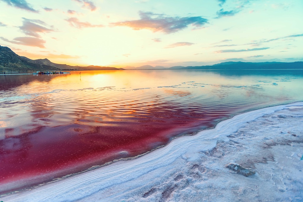
The red salt Urmia lake stretches between the provinces of West Azerbaijan and East Azerbaijan. Due to the decreasing amount of precipitation each year, it is gradually decreasing in size, now only 10% of its volume from the basin of 50 years ago remains. Until July 2016, the lake had its usual emerald colour. However, due to the seemingly another hot summer, the salt concentration in the water increased exponentially. As a result, the Dunaliella algae naturally living in Lake Urmia responded to the change in the external environment by significantly increasing the synthesis of carotenoids. Since then, the water in Urmia Lake has been a ruby colour.
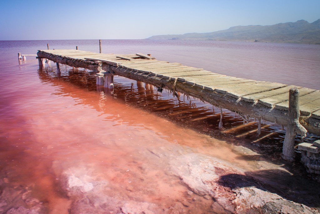
Lake Urmia lies in a tectonic depression to the east of the Kurdish Mountains at an altitude of 1,275m. It stretches from north to south; its maximum length is about 140 km and width is about 40-55 km. The area varies from 5,200 to 6,000 sq. km. The average depth is 5 m, the maximum is up to 16m .The lake has 102 islands, with pistachio forests (Pistacia atlantica) on the larger ones; a cluster of 50 small islands is found in the southern part. The lake does not freeze in winter, it is navigable. Along the shores there are solonchaks, in the mouths of the rivers there are marshes with brushwood and reeds; the shores are mostly uninhabited. Fish are absent, but the abundance of algae provides food for small crustaceans - artemia. Pelicans, flamingos, and shags nest on the lake, and migratory birds use the islands as a stopover on their migration routes. In 1967, a national park which includes most of the lake was created. Now Urmia Lake is on the brink of extinction due to prolonged droughts and excessive human activities.
Maharlu Lake is another salt lake. It is located 25 km from Shiraz. The water in the lake is pink. This peculiarity attracts a lot of tourists who want to take fantastic pictures against its background. Maharlu Lake is seasonal and dries up by the end of summer.
You can have a beach holiday both on the shores of the Caspian Sea and the Persian Gulf. The main beaches of the country are on the island of Kish, the Pearl of the Persian Gulf. Here is the most popular resort in Iran and one of the most famous resorts in the Middle East. Kish Island is 17 km from the mainland. Tourists should keep in mind that the beaches in Iran are separate for males and females. However, if you stay on the beach at the hotel, it is allowed for men and women to rest together. Men are allowed to be on the beach in swimming trunks. Women must be in a closed bathing suit. Swimming and sunbathing in swimsuits is allowed only on certain paid beaches. Hotels on the island are plenty, there are also many shopping centres. There are several sports facilities here as well.
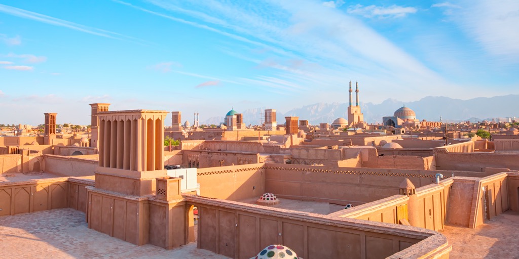
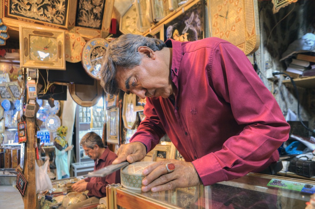
It is surely worth visiting a traditional oriental bazaar where you can buy not only goods and souvenirs, but also learn the local culture. Bazaars in major cities of Iran (in Tehran, Mashhad, Tabriz, Isfahan, Shiraz, Kerman) in addition to the usual rows of shops have magnificent architecture preserved from the old days: caravanserais, mosques, madrassas, as well as tea houses and baths. The main goods in the country which usually attract travellers are silk products, Persian carpets, embossing crafts, jewellery, and spices.
Due to the dry climate and extensive agricultural activities, the flora in Iran is quite scarce. Almost all the steppes of the country (according to some estimates - about 90%) have been destroyed. As a result, wildlife is on the verge of extinction. That is why now Iran is actively creating protected area in order to restore and preserve the landscapes and species diversity of flora and fauna. There are about 200 protected areas in Iran, including 16 national parks and 30 wildlife sanctuaries.
The most popular national park in the country is Golestan. It is included in the UNESCO list as a Biosphere Reserve. The territory of the park is so huge that several climatic zones alternate with each other, which contributes to the great diversity of species. Near the park, there are resort areas of Gulistan, Golshan, Golzar and Abshar. So there is usually a large number of tourists here.
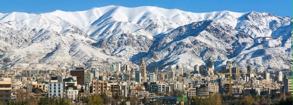
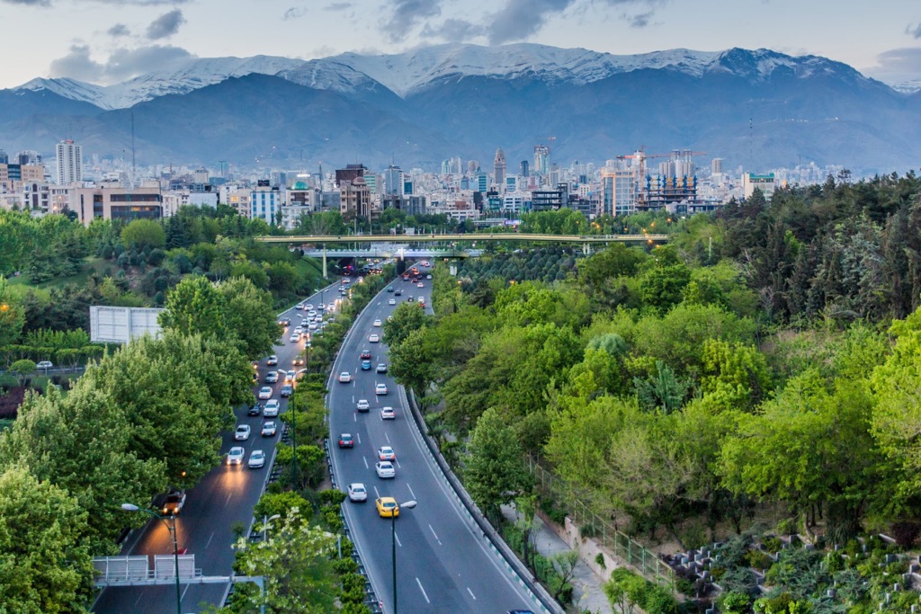
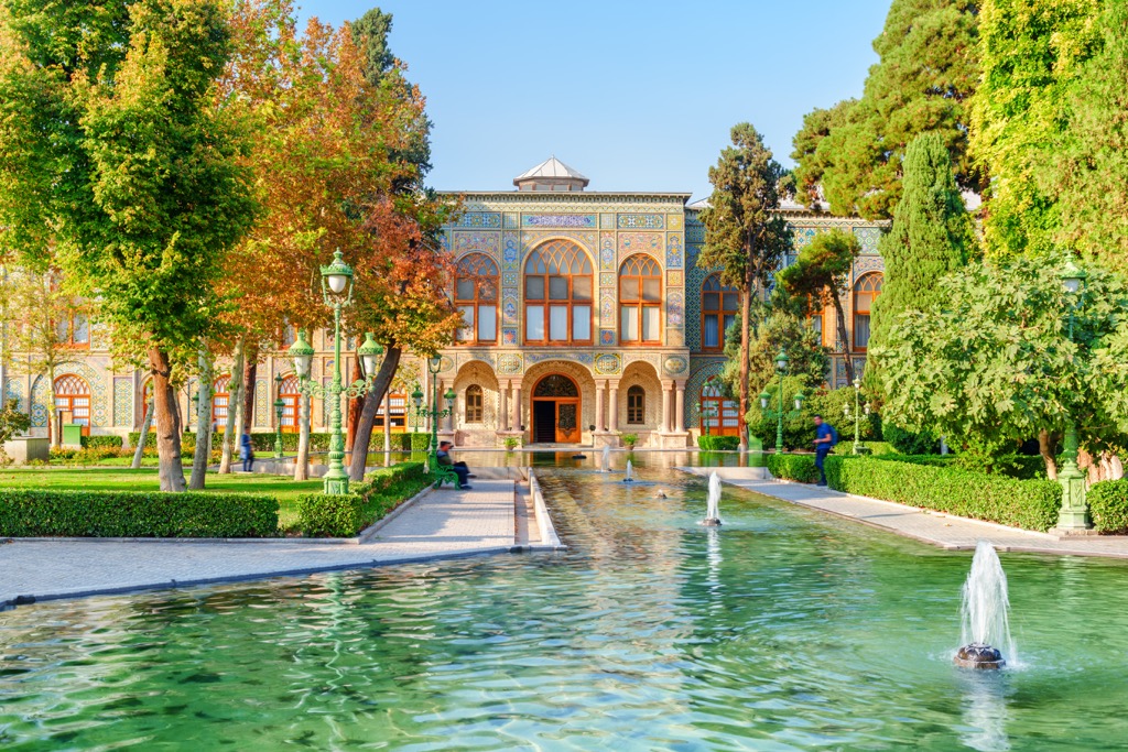
Tehran is the capital of Iran. It is located in the north of the country, at the foot of the Elburz Range. Tehran is not only the largest city in Iran, but it is also one of the largest cities in Asia. The Caspian Sea coast is just 90 km to the north from Tehran. There are several versions of the origin of the name. Some historians refer to the fact that the word Tehran comes from the Parthian city of Tiran, which exists near the current capital. And the word ‘Tiran’ itself is translated as ‘the abode of Tyr’ (the god of rain). Other historians adhere to the version that Tehran means ‘a warm place’, as opposed to the word Shemiran, which means ‘a cold place’ (this is the northern district of Tehran).
This lively metropolis is brimming with sights like a jug full of jewels. Here many theatres and museums open their doors to visitors. A visit to the Miniatures Garden Museum of Iran is especially enlightening. In the open-air park, all the main attractions of the country are collected in 1:25 size: the Fortress of Bam (in Kerman), Imam Square (in Isfahan), the Mausoleum (in Soltania), Persepolis (in Fars) and many others. The park covers an area of 3 hectares.
In the western part of Tehran, there is an artificial lake Chitgar of enormous size (130 hectares) and a recreational area around it. Initially, its creation was dictated by environmental measures to stop the occasional spring floods, which previously swept away everything in their path. Gradually, the area around the lake was improved as well. There is a beautiful promenade, amusement parks and catamaran rentals, restaurants and many boutiques. Near the lake is a botanical garden, water park called Opark, and the film city called Ghazali. A visit to Ghazali will allow you to plunge into the atmosphere of the past and walk along the ancient streets. This interesting place is an active movie site, it features the scenery of the old Tehran city and there are also recreated objects of ancient Egypt and Jerusalem.
On the way to the centre of the city is the giant Azadi Tower, which is 45m high.
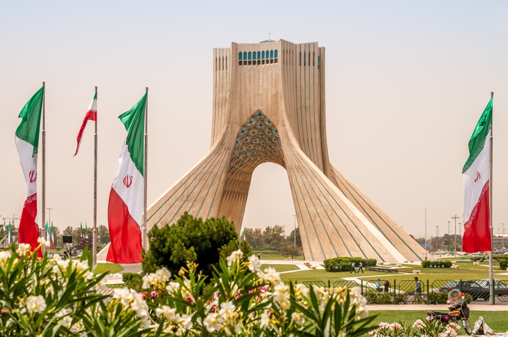
The Azadi Tower is also called the symbol of the Islamic revolution or the tower of freedom. There is a museum, a conference hall, a library and a cinema inside. The observation deck, which offers a panoramic view of Tehran against a background of towering mountains, can be climbed on foot or by elevator.
If you want to get another angle of Tehran, climb the observation deck of the Mirad Tower. It was designed in the form of a minaret. It is the fourth highest TV tower in the world.
One of the features of the capital is an abundance of mosques (about 1000) and churches (about 300).
The palaces and museums - Golestan Palace, National Treasury, White Palace (Palace of Nations) and Green Palace (Shahwand Palace), Niavaran Palace - will allow you to experience the life of the rulers of the country.
One big attraction is the Darband (or Derbend) district of the city, located in the north of Tehran. The word "Darband" translates as ‘a closed gate’. There is a gorge of the same name and the river Darband, which originates from a small square. Here is the northern entrance to the district. And at the end of the street you can see a monument to a mountain climber. It is in this area that the popular mountaineering route to Mount Tochal begins. An alternative to walking in Darband is to take the cable car.
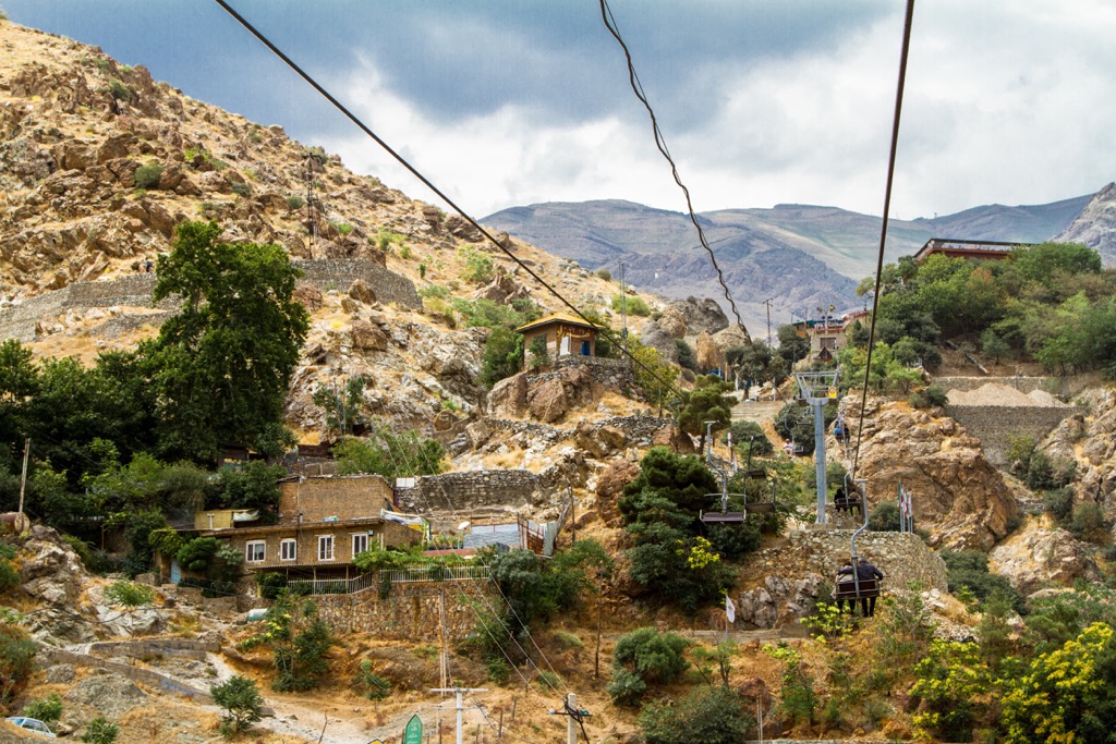
Another tourist area of the capital is Darake. At the end of Darake Street begins another popular route for climbing the mountain. There are several such trails in the area.
You can enjoy some natural serenity without leaving Tehran. There is the ice waterfall Hemlon located in the northwest of the capital. Here is also the Hemlon Valley and the caves. There you can also see the remains of an old castle.
Iran has very good transport accessibility. You can get here by air, by rail or by bus.
There are a huge number of airports in the country. There are 2 airports in the capital: Tehran Mehrabad and Tehran Imam Khomeini. The nearest airports to Tehran are Shiraz, Yazd, Esfahan, Kerman, Sirjan.
Within the country, there is developed public transport, the subway and inexpensive taxi services. You can travel between cities in Iran by plane or train. Bus is the cheapest intercity transport. However, you should be prepared for the fact that there is virtually no customer service.
There also used to be an exotic way to travel to Iran - a trip by a comfortable Golden Eagle train on the Budapest-Tehran route, which is called the Treasures of Persia. The train departed from Hungary, passed through Romania, Bulgaria, Turkey and then arrived in Iran. The first stop in Iran was the city of Tabriz, where travellers could visit several attractions. Then the train made stops in other cities Yazd - Isfahan - Shiraz - Persepolis. The final point of the route was the city of Tehran. The trip was designed for two weeks. They might bring back the luxury train again.
The high tourist season in the country is divided into two periods: from mid-April to early June and from late September to early November.
In spring, locals have the month of Ramadan when Muslims strictly observe the fast. Months are counted by new moon in Islam, that is why there might be a slight shift each year, depending on the moon cycle. Usually, Ramadan takes place at the end of March - mid April. In this regard, there may be difficulties with food since many cafes are closed and there is hardly any entertainment available. You should take this into account when planning a trip to Iran.
In summer, you can visit the country if you are not afraid of the heat.
In wintertime, Iran opens ski resorts that will please you not only with their slopes, but also with reasonable prices.
If your passport is marked for a visit to the U.S., Iran may refuse the entry. If a visit to Israel is marked, then the entry into the country will be refused unequivocally.
Customs regulations feature a number of restrictions which it is better to know. Below is a list of commonly allowed and prohibited items for import and export. However, it is advisable to study the restrictions in more detail before the trip lest you should carrey anything illegal across the border.
It is commonly forbidden to import:
It is also forbidden to:
It is not recommended to bring into the country things related to Israel, directly or indirectly.
It is commonly permitted to import:
It is also allowed to export:
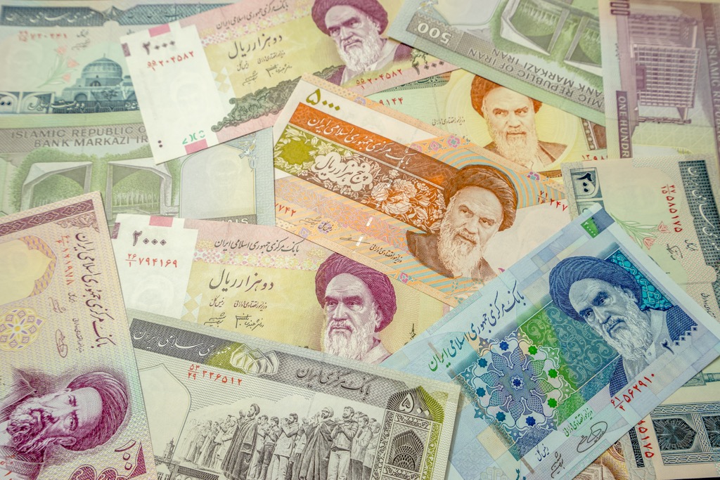
Iran currently has two currencies, which might be confusing for tourists. Iranian official currency is Rial which is also known as IRR, but in daily payments people mostly use Toman as the main circulation money used for purchasing in Iran. Toman is one tenth of Rial, for example, 2,000 Tomans is 20,000 Rials.
Another peculiarity is how prices are quoted orally. People sometimes do not mention thousand or million. For example, if you buy a handmade Persian rug or golden jewellery and the seller tells you it costs 3 Tomans, definitely it means 3 Million Tomans or 30 Million Rials and when you pay for snacks and it costs 3 Tomans, you should pay 3 Thousand Tomans or 30 Thousand Rials.
Mind you, that dollars, euros and pounds are accepted almost everywhere, but it is always a good idea to have some local currency on you.
Visa and Mastercard do not work in the country, the available ATM machines are only for local Iranian Credit Card. Therefore, you must carry cash either dollars or euros, or the local currency - Iranian rial. Foreign exchange in Iran is different from other countries. You can exchange money in the bank, or in special currency exchange offices (bureau de change) called Sarafi, but they do not take credit cards, only cash! Mind you that the Iranian currency market is different from the official rate and varies greatly day by day or even hourly depending on the political agenda and the current economic status. The open market USD rate is currently 6 times as high as the official exchange rate of the Iran Central Bank.
It is possible to rent a car in Iran but bear in mind that there can be problems with parking, with handing in the car in another place (not from where you initially borrowed it), with the return of the deposit. Another headache is that local drivers do not always respect the road rules. In this regard, many tourists prefer to use public transport or cabs.
Should you wish to go sightseeing outside Tehran, it is much advisable to hire a guide or escort because too many nuances arise during the trip, e.g. coordination of drivers, hotels, you need to negotiate with locals to be allowed into some mosques, if they are closed to tourists, etc.
Cafes or restaurants in the country are not easy to find at first because they are usually located in basements or in back alleys. Yet, once you get the knack of locating the catering facilities, you will enjoy all kinds of omnipresent eateries, such as kebab shops, coffee shops, street food vendors etc.
Healthcare in the country is expensive and not always available. So if necessary, bring your usual medicine with you. Emergency medical care in the country is free for everybody but further treatment is not free and should be covered either by the patient or by insurance.
In general, there is cell phone coverage almost everywhere, except in mountainous areas and deserts. At the same time, phone service is not of very high quality, and mobile Internet is quite slow. It is not always possible to communicate via messengers and social networks because many social networks and sites are blocked in Iran. Email services work fine.
Iran has strong governance by the laws of Islam. In this regard, a certain dress code should be observed.
Women are not allowed to be photographed, or touched, told jokes of an obscene nature. It is not customary to show feelings for your other half in public, even if it is just a touch. Such behaviour can cause a negative reaction of local residents.
The country has a prohibition law, the violation of which entails arrest and corporal punishment.
The use of drugs is forbidden. Violation of the rule can result in long-term imprisonment. If illegal substances are found in large quantities, the ultimate punishment isthe death penalty.

It is forbidden to take photographs of government buildings. Religious edifices, including mosques, can be photographed only with the consent of their employees.
Before entering a mosque, take off your shoes. Women must cover their face as well as their hands with a full hijab. In addition, they may not be allowed into certain parts of the mosque.
Despite the long list of the dos and the don’ts of staying in the country, a visit to Iran will not leave even the most sophisticated traveller indifferent and will make a most lasting impression.