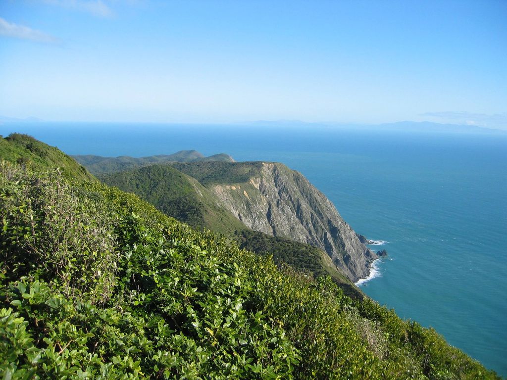
Kapiti Island ([kɑːpiti]), sometimes written as Kāpiti Island, is an island nature reserve located 5.6 km (3 mi) off the west coast of the lower North Island of New Zealand and within the Kāpiti Coast District. Parts of the island were previously farmed, but it is now a predator-free sanctuary for endemic birds, including many endangered birds. The island is 10 km (6.2 mi) long, running southwest/northeast, and roughly 2 km (1.2 mi) wide, being more or less rectangular in shape, and has an area of 19.65 km2 (7.59 sq mi). The island is separated from the North Island by the Rauoterangi Channel. The highest point on the island is Tūteremoana, 521 m (1,709 ft). The seaward (west) side of the island is particularly rocky and has high cliffs, some hundreds of metres high, that drop straight into the sea. The cliffs are subject to very strong prevailing westerly winds and the scrubby vegetation that grows there is low and stunted by the harsh environmental conditions. A cross-section of the island would show almost a right-angled triangle, revealing its origins from lying on a fault line (part of the same ridge as the Tararua Range). The island's vegetation is dominated by scrub and forest of kohekohe, tawa, and kanuka. Most of the forest is regenerating after years of burn-offs and farming, but some areas of original bush remain, with 30 m (98 ft) trees.
Show more
Sun and Moon
Mon
Tue
Wed
Thu
Fri
Sat
Sun
May 2022
Date and time
00:00
06:00
12:00
18:00
Today
--
--
Sunrise
--
Sunset
--
Moonrise
--
Moonset
Phase
🌔 Waxing Gibbous
The perfect light time for beautiful photos:
--
Sunrise
--
Sunset
PeakVisor app
Get the app on your smartphone
New Panorama Tools
Trace location on the map
Measure distances
All the instruments are available in the context menu as well.
We use GPS information embedded into the photo when it is available.
3D mountains overlay
Adjust mountain panorama to perfectly match your photos because recorded by camera photo position might be imprecise.
Move tool
Rotate tool
Zoom
More customization
Choose which peak labels should make into the final photo and what photo title should be.
Next
Photo Location
Satellitte
Flat map
Relief map
Latitude
Longitude
Altitude
OR
Latitude
°'''
Longitude
°'''
Apply
Register Peak
Peak Name
Latitude
Longitude
Altitude
Register
Teleport
PeakVisor
This 3D model of Sagarmatha National Park in Nepal was made using the PeakVisor app topographic data. The mobile app features higher precision models worldwide, more topographic details, and works offline. Download PeakVisor maps today.
Download OBJ model
PeakVisor
The download should start shortly. If you find it useful please consider supporting the PeakVisor app.
PeakVisor for iOS and Android
Be a superhero of outdoor navigation with state-of-the-art 3D maps and mountain identification in the palm of your hand!


_(cropped).jpg)


