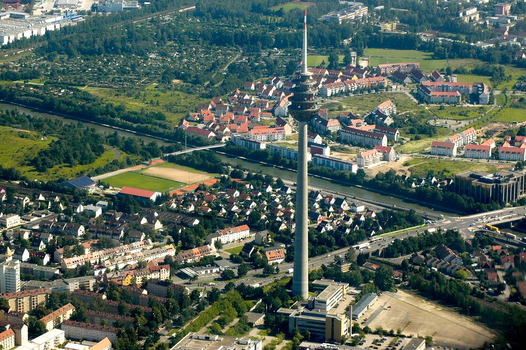
The Fernmeldeturm Nürnberg, the tallest structure in Bavaria, is a telecommunication tower in Nuremberg, southern Germany. Also called the Nürnberger Ei ("Egg of Nuremberg") because of its egg-shaped tower basket in a height of 185 metres, it is 292 metres high and was built between 1977 and 1980 according to blueprints by architect Erwin Heinle. The tower basket accommodates transmission mechanisms for Frequency modulation, DAB, UMTS, pager, amateur radio and a microwave radio relay link and – closed since 1991 – a rotating restaurant and a prospect platform. Responsible operator is the DFMG Deutsche Funkturm (German radio tower) GmbH, a subsidiary of Deutsche Telekom based in Münster. From 22 January 2003 to 4 April 2003 the Nürnberg telecommunication tower also served for the spreading of the program of megaradio on mediumwave frequency 945 kHz. For this a wire antenna was strung along the tower shaft, from the top of the tower to the roof of an operating building near the tower. Since July 2009 a 360° Panoramacamera shows the view over Nuremberg from 194 metres.
Show more
Sun and Moon
Mon
Tue
Wed
Thu
Fri
Sat
Sun
May 2022
Date and time
00:00
06:00
12:00
18:00
Today
--
--
Sunrise
--
Sunset
--
Moonrise
--
Moonset
Phase
🌔 Waxing Gibbous
The perfect light time for beautiful photos:
--
Sunrise
--
Sunset
PeakVisor app
Get the app on your smartphone
New Panorama Tools
Trace location on the map
Measure distances
All the instruments are available in the context menu as well.
We use GPS information embedded into the photo when it is available.
3D mountains overlay
Adjust mountain panorama to perfectly match your photos because recorded by camera photo position might be imprecise.
Move tool
Rotate tool
Zoom
More customization
Choose which peak labels should make into the final photo and what photo title should be.
Next
Photo Location
Satellitte
Flat map
Relief map
Latitude
Longitude
Altitude
OR
Latitude
°'''
Longitude
°'''
Apply
Register Peak
Peak Name
Latitude
Longitude
Altitude
Register
Teleport
PeakVisor
This 3D model of Sagarmatha National Park in Nepal was made using the PeakVisor app topographic data. The mobile app features higher precision models worldwide, more topographic details, and works offline. Download PeakVisor maps today.
Download OBJ model
PeakVisor
The download should start shortly. If you find it useful please consider supporting the PeakVisor app.
PeakVisor for iOS and Android
Be a superhero of outdoor navigation with state-of-the-art 3D maps and mountain identification in the palm of your hand!