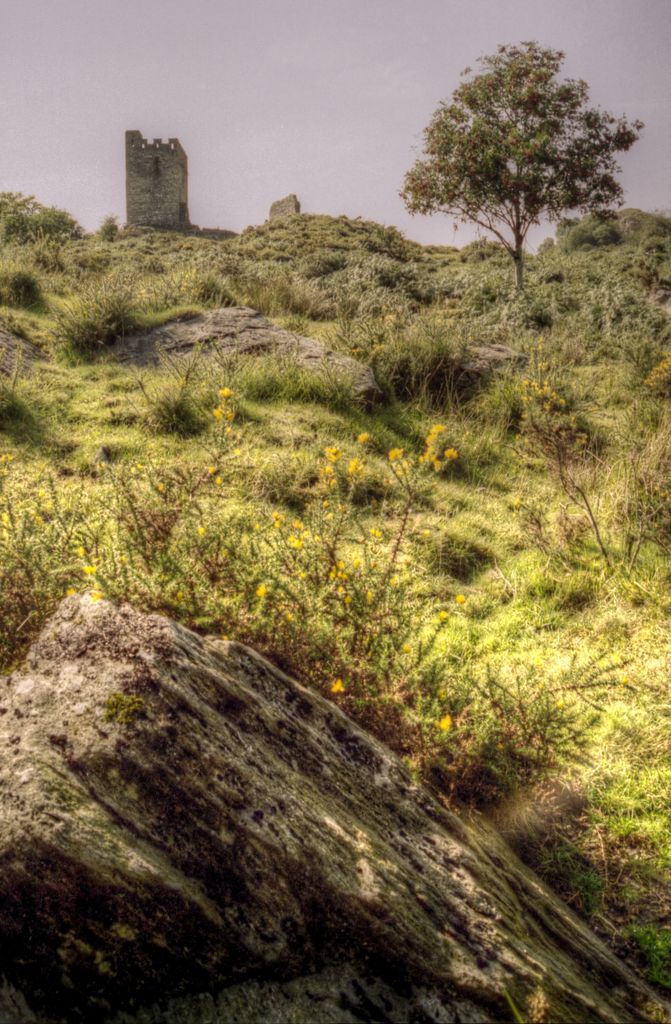
Dolwyddelan Castle ( dol-with-EL-an; Welsh: Castell Dolwyddelan; Welsh pronunciation: [kastɛɬ dɔlwɪð’ɛlan]) is a thirteenth-century castle located west of Dolwyddelan in Conwy County Borough, North Wales. Tomen Castell, a late twelfth-century tower, is located south-east of the castle. Dolwyddelan Castle was probably begun by Llywelyn ab Iorwerth, the ruler of the Kingdom of Gwynedd, between 1210 and 1240 to defend an east–west route within the kingdom. It superseded Tomen Castell, a small tower possibly built by Llywelyn's father, Iorwerth Drwyndwn. Dolwyddelan was captured by Edward I of England in 1283, and despite being immediately refortified its military significance subsequently declined. In 1488 Maredudd ab Ieuan, a member of a family from neighbouring Eifionydd, purchased the lease and repaired the structure, but it was ruinous by the mid-nineteenth century. Between 1848 and 1850 the keep was restored and reconstructed by Peter Drummond-Burrell, 22nd Baron Willoughby de Eresby, and in 1930 the castle was placed in state care; it is currently managed by Cadw, the Welsh Government's historic environment service, and open to the public. It was designated a grade I listed building in 1997 and is a scheduled monument. The castle is built on a small knoll and consists of a keep on the east side and a tower on the west, linked by walls to form a roughly circular enclosure. The building history is uncertain, but the keep is the oldest structure. It has been heightened twice, first by either Edward I or Maredudd ab Ieuan and second during the nineteenth-century restoration. The western tower may have been constructed in the late thirteenth century by Llywelyn ap Gruffudd or shortly after the English capture of the castle.
We use GPS information embedded into the photo when it is available.
3D mountains overlay
Adjust mountain panorama to perfectly match your photos because recorded by camera photo position might be imprecise.
Move tool
Rotate tool
Zoom
More customization
Choose which peak labels should make into the final photo and what photo title should be.
Next
Photo Location
Satellitte
Flat map
Relief map
Latitude
Longitude
Altitude
OR
Latitude
°'''
Longitude
°'''
Apply
Register Peak
Peak Name
Latitude
Longitude
Altitude
Register
Teleport
PeakVisor
This 3D model of Sagarmatha National Park in Nepal was made using the PeakVisor app topographic data. The mobile app features higher precision models worldwide, more topographic details, and works offline. Download PeakVisor maps today.
Download OBJ model
PeakVisor
The download should start shortly. If you find it useful please consider supporting the PeakVisor app.
PeakVisor for iOS and Android
Be a superhero of outdoor navigation with state-of-the-art 3D maps and mountain identification in the palm of your hand!


.jpg)


