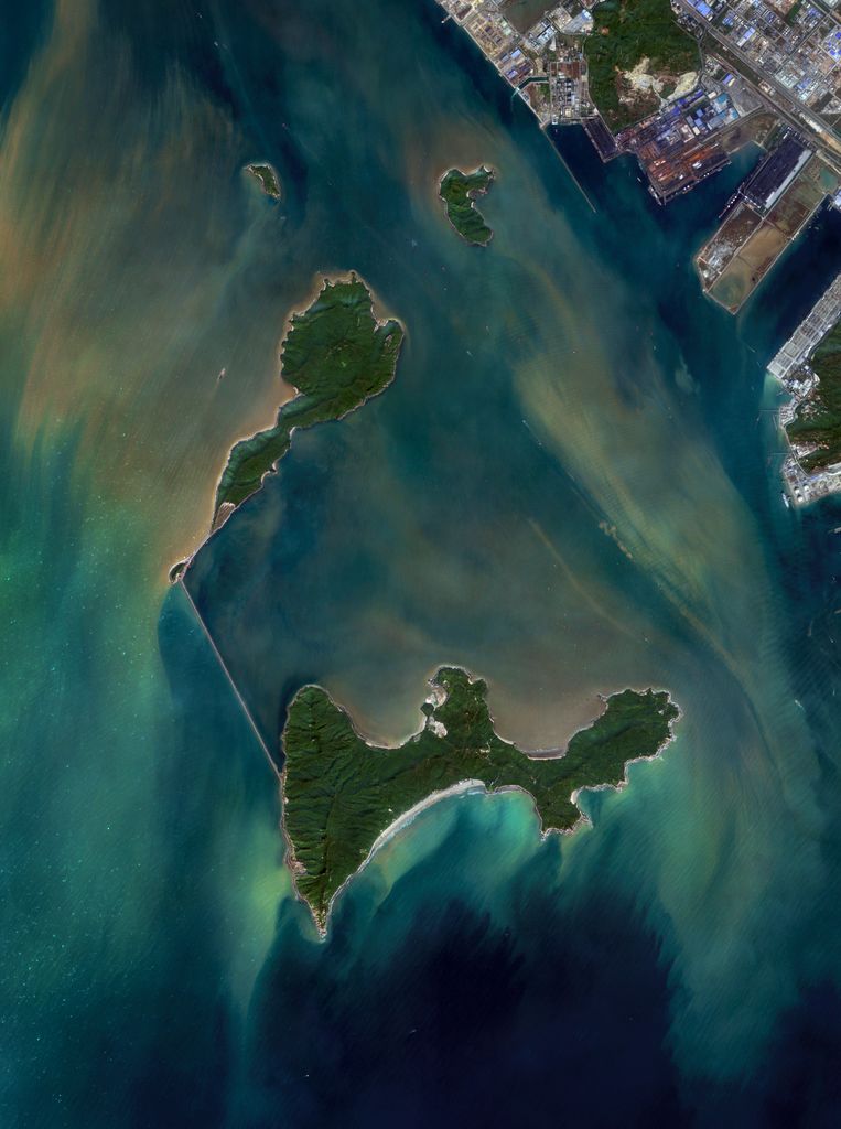
Damang Island (alternatively romanized as Damang Dao, Damang, Taimong, Ta-mang, Ta-wang) is an uninhabited island off the southern coast of Guangdong province in the People's Republic of China. It is located in the Pearl River estuary, South China Sea, 6 kilometres (3.7 miles) west of the Zhuhai Gaolan Port Economic Zone, 4.5 kilometres (2.8 miles) north of Hebao island and approximately 100 km West-Southwest of Hong Kong. Administratively, this sub-tropical island belongs to the prefecture-level city of Zhuhai, and may be considered part of the so-called Chinese Riviera. It has a total area of 5.2 square kilometres (2.0 square miles), measures 5.2 kilometres (3.2 miles) long and 2.5 kilometres (1.6 miles) wide. It serves as an ecotourism destination, and a research station for the study of its well-preserved ecosystem. The many varieties of rare plant and animal species in its tropical rain forest, include 600 kinds of ornamental plants, such as Podocarpus, Syzygium, Emblica, and 10 kinds of rare wild animals including deer, monkeys and turtles. Its name is derived from the abundance of mango trees on the island.
Show more
Sun and Moon
Mon
Tue
Wed
Thu
Fri
Sat
Sun
May 2022
Date and time
00:00
06:00
12:00
18:00
Today
--
--
Sunrise
--
Sunset
--
Moonrise
--
Moonset
Phase
🌔 Waxing Gibbous
The perfect light time for beautiful photos:
--
Sunrise
--
Sunset
PeakVisor app
Get the app on your smartphone
New Panorama Tools
Trace location on the map
Measure distances
All the instruments are available in the context menu as well.
We use GPS information embedded into the photo when it is available.
3D mountains overlay
Adjust mountain panorama to perfectly match your photos because recorded by camera photo position might be imprecise.
Move tool
Rotate tool
Zoom
More customization
Choose which peak labels should make into the final photo and what photo title should be.
Next
Photo Location
Satellitte
Flat map
Relief map
Latitude
Longitude
Altitude
OR
Latitude
°'''
Longitude
°'''
Apply
Register Peak
Peak Name
Latitude
Longitude
Altitude
Register
Teleport
PeakVisor
This 3D model of Sagarmatha National Park in Nepal was made using the PeakVisor app topographic data. The mobile app features higher precision models worldwide, more topographic details, and works offline. Download PeakVisor maps today.
Download OBJ model
PeakVisor
The download should start shortly. If you find it useful please consider supporting the PeakVisor app.
PeakVisor for iOS and Android
Be a superhero of outdoor navigation with state-of-the-art 3D maps and mountain identification in the palm of your hand!