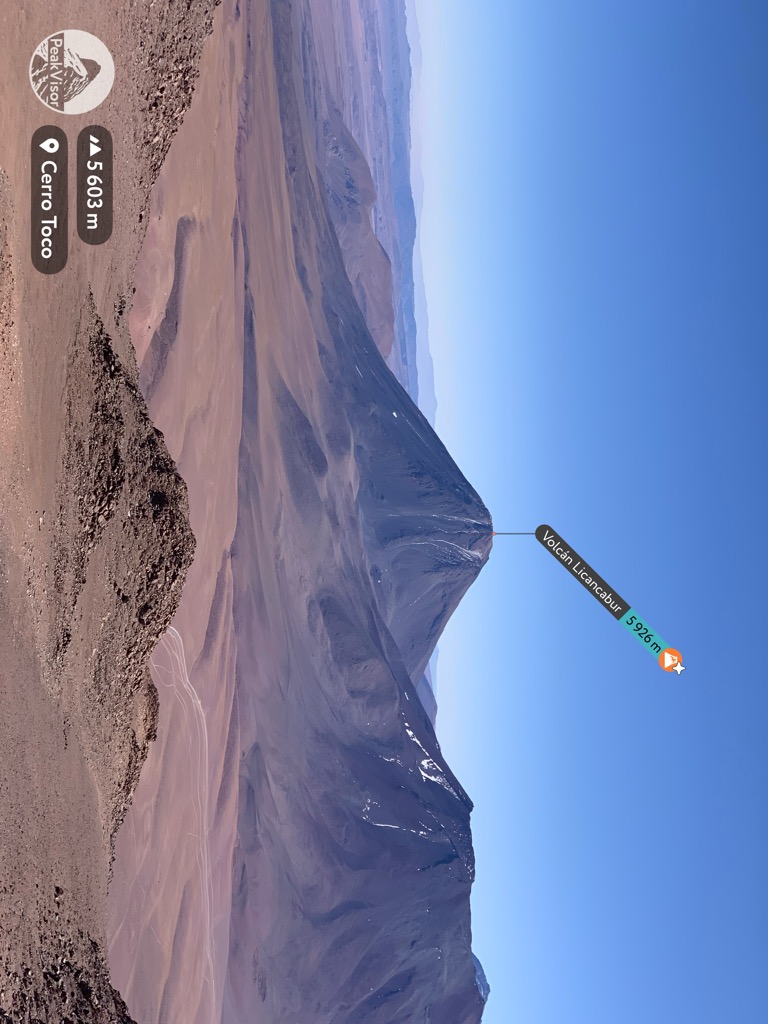
Licancabur (Spanish pronunciation: [likaŋkaˈβuɾ]) is a stratovolcano on the border between Bolivia and Chile, south of the Sairecabur volcano and west of Juriques. Part of the Andean Central Volcanic Zone, it has a prominent, 5,916-metre (19,409 ft)-high cone. A 400–500-metre (1,300–1,600 ft) summit crater containing Licancabur Lake, a crater lake which is among the highest lakes in the world, caps the volcano. There are no glaciers owing to the arid climate. Numerous animal species and plants live on the mountain.
Licancabur formed atop of Pleistocene ignimbrites and has been active during the Holocene, after the ice ages. Three stages of lava flows emanate from the edifice and have a young appearance. Although no historic eruptions of the volcano are known, lava flows extending into Laguna Verde have been dated to 13,240 ± 100 BP and there may be residual heat in the mountain. The volcano has primarily erupted andesite, with small amounts of dacite and basaltic andesite.
Several archaeological sites occur on the mountain, both on its summit and at its northeastern foot. They were built presumably by the Inca or Atacama people for religious and cultural ceremonies, and are among the most important in the region. The mountain is the subject of a number of myths, which view it as the husband of another mountain, the hiding place of Inca or the burial of an Inca king.
By elevation Volcán Licancabur is
# 13 out of 410 in Provincia de El Loa # 62 out of 10580 in Chile # 15 out of 973 in Región de Antofagasta # 25 out of 3781 in Bolivia # 4 out of 150 in Provincia Sur Lípez # 2 out of 66 in Eduardo Avaroa Andean Fauna National Reserve # 6 out of 1235 in Potosí
By prominence Volcán Licancabur is
# 10 out of 410 in Provincia de El Loa # 80 out of 10580 in Chile # 12 out of 973 in Región de Antofagasta # 19 out of 3781 in Bolivia # 1 out of 150 in Provincia Sur Lípez # 1 out of 66 in Eduardo Avaroa Andean Fauna National Reserve # 9 out of 1235 in Potosí
We use GPS information embedded into the photo when it is available.
3D mountains overlay
Adjust mountain panorama to perfectly match your photos because recorded by camera photo position might be imprecise.
Move tool
Rotate tool
Zoom
More customization
Choose which peak labels should make into the final photo and what photo title should be.
Next
Photo Location
Satellitte
Flat map
Relief map
Latitude
Longitude
Altitude
OR
Latitude
°'''
Longitude
°'''
Apply
Register Peak
Peak Name
Latitude
Longitude
Altitude
Register
Teleport
PeakVisor
This 3D model of Sagarmatha National Park in Nepal was made using the PeakVisor app topographic data. The mobile app features higher precision models worldwide, more topographic details, and works offline. Download PeakVisor maps today.
Download OBJ model
PeakVisor
The download should start shortly. If you find it useful please consider supporting the PeakVisor app.
PeakVisor for iOS and Android
Be a superhero of outdoor navigation with state-of-the-art 3D maps and mountain identification in the palm of your hand!