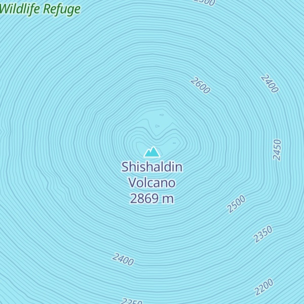
Shishaldin Volcano, or Mount Shishaldin (), is a moderately active volcano on Unimak Island in the Aleutian Islands chain of Alaska in the United States. It is the highest mountain peak of the Aleutian Islands and rises about 10,000 m (33,000 ft) from the bottom of the Aleutian Trench 140 mi (230 km) south of the volcano. The volcano's topographic contour lines are nearly perfect circles above 6,500 ft (2,000 m). The lower north and south slopes are somewhat steeper than the lower eastern and western slopes. Only on the volcano's west flank between about 3,500 to 6,500 ft (1,100 to 2,000 m) are small areas of rough topography which are remnants of an older collapsed volcano upon which Shishaldin is built. The volcano is the westernmost of three large stratovolcanoes along an east–west line in the eastern half of Unimak Island.
The upper 6,600 ft (2,000 m) is almost entirely covered by glacial snow and ice. In all, Shishaldin's glacial shield covers about 35 sq mi (91 km2). It is flanked to the northwest by 24 monogenetic parasitic cones, an area blanketed by massive lava flows. The Shishaldin cone is less than 10,000 years old and is constructed on a glacially eroded remnant of an ancestral somma and shield. Remnants of the older ancestral volcano are exposed on the west and northeast sides at 4,900 to 5,900 ft (1,500 to 1,800 m) elevation. The Shishaldin edifice contains about 300 km3 (72 cu mi) of material. A very steady steam plume rises from its small summit crater which is about 500 ft (150 m) across and slightly breached along the north rim. In appearance, the volcano can vary from nearly completely white to almost all black, depending on the occurrence of ashfall deposits.
In 1967, Shishaldin Volcano was designated as a National Natural Landmark - the Shishaldin Volcano National Natural Landmark - by the National Park Service. The landmark is 62,714 acres (25,379 ha) and a plaque was erected near the coast.
By elevation Shishaldin Volcano is
# 1 out of 82 in Aleutians East # 1 out of 297 in the Aleutian Range
By prominence Shishaldin Volcano is
# 7 out of 3806 in Alaska # 12 out of 91437 in USA # 1 out of 82 in Aleutians East # 1 out of 297 in the Aleutian Range
We use GPS information embedded into the photo when it is available.
3D mountains overlay
Adjust mountain panorama to perfectly match your photos because recorded by camera photo position might be imprecise.
Move tool
Rotate tool
Zoom
More customization
Choose which peak labels should make into the final photo and what photo title should be.
Next
Photo Location
Satellitte
Flat map
Relief map
Latitude
Longitude
Altitude
OR
Latitude
°'''
Longitude
°'''
Apply
Register Peak
Peak Name
Latitude
Longitude
Altitude
Register
Teleport
PeakVisor
This 3D model of Sagarmatha National Park in Nepal was made using the PeakVisor app topographic data. The mobile app features higher precision models worldwide, more topographic details, and works offline. Download PeakVisor maps today.
Download OBJ model
PeakVisor
The download should start shortly. If you find it useful please consider supporting the PeakVisor app.
PeakVisor for iOS and Android
Be a superhero of outdoor navigation with state-of-the-art 3D maps and mountain identification in the palm of your hand!