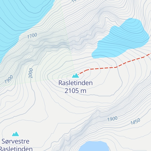
Rasletind or Rasletinden is a mountain on the border of Vang Municipality and Vågå Municipality in Innlandet county, Norway. The 2,105-metre (6,906 ft) tall mountain is located in the Jotunheimen mountains within Jotunheimen National Park. The mountain sits about 60 kilometres (37 mi) southwest of the village of Vågåmo and about 15 kilometres (9.3 mi) northwest of the village of Beitostølen. The mountain is surrounded by several other notable mountains including Gråhøi to the east; Bukkehåmåren, Høgdebrotet, and Eggi to the north; Tjønnholstinden and Tjønnholsoksle to the northwest; and Kalvehøgde and Leirungskampen to the west.
The mountain has two main summits, named Øystre Rasletind and Rasletind. The higher summit reaches an elevation of 2,105 metres (6,906 ft) above sea level. It is located on the border between the municipalities of Vang and Vågå. The secondary peak reaches an elevation of 2,010 metres (6,590 ft) above sea level a little further to the east. That peak forms a tripoint for the municipal borders of Vang, Vågå, and Øystre Slidre municipalities. This mountain forms the southeasternmost edge of the Jotunheimen mountains. The mountain is situated on the western side of the Valdresflye high mountain plains. The mountain is the eastern end of the long east-west Kalvehøgde massif. The summit can be observed from most of the mountain areas south and east of Jotunheimen. Both summits are located close to the main road Norwegian County Road 51 which runs across Valdresflye.
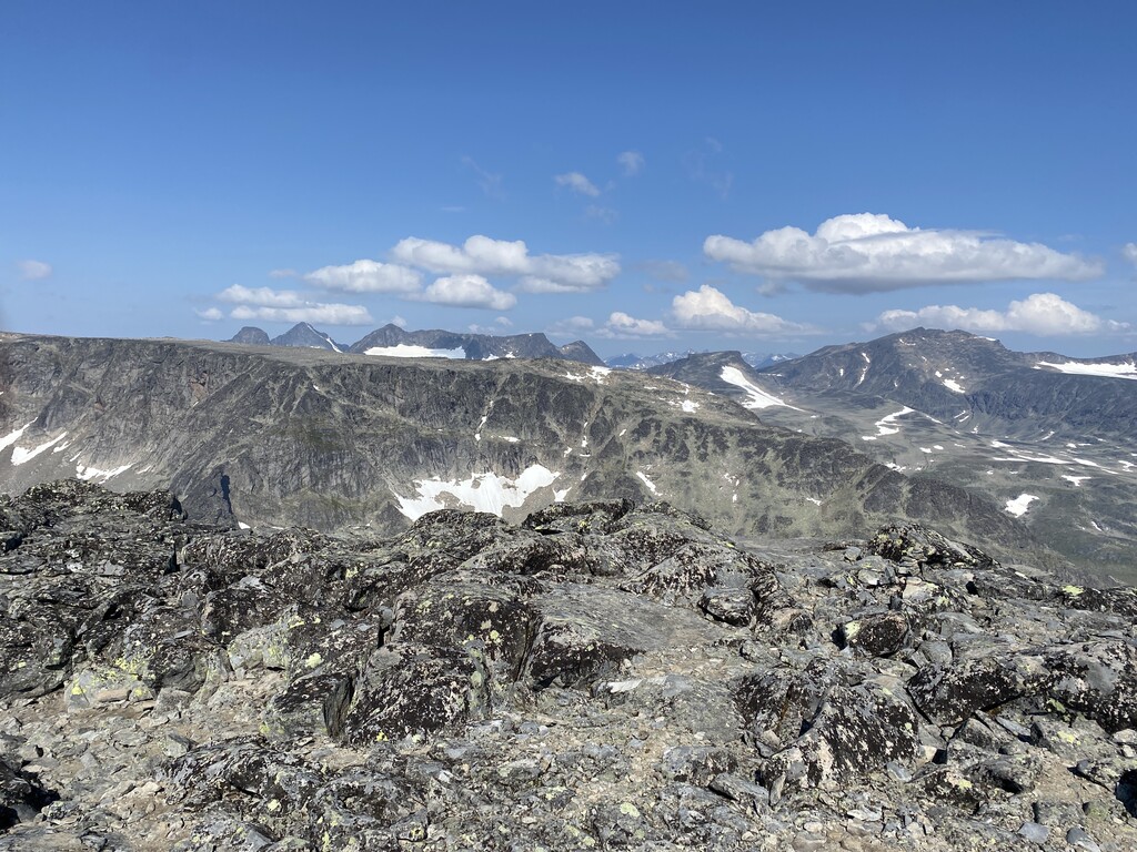
The mountain is among the furthest south of all the 2,000-metre (6,600 ft) peaks in Norway and it is made of the extremely hard gabbro rock. The gabbro in Rasletind is of the normal "gray-with-black-specs" variety which can easily be observed on the slopes that are covered with snow most of the year and gives no support to lichen colonies. The view from the summits is one of the best in southern Norway. On a clear day, you can see almost as far as Oslo. You can see the Rondane range to the east-northeast and the Dovrefjell range to the north. Due south you see the summit of the beacon of Øystre Slidre, Bitihorn, and you also see the lakes of Vinstri and Bygdin.
We use GPS information embedded into the photo when it is available.
3D mountains overlay
Adjust mountain panorama to perfectly match your photos because recorded by camera photo position might be imprecise.
Move tool
Rotate tool
Zoom
More customization
Choose which peak labels should make into the final photo and what photo title should be.
Next
Photo Location
Satellitte
Flat map
Relief map
Latitude
Longitude
Altitude
OR
Latitude
°'''
Longitude
°'''
Apply
Register Peak
Peak Name
Latitude
Longitude
Altitude
Register
Teleport
PeakVisor
This 3D model of Sagarmatha National Park in Nepal was made using the PeakVisor app topographic data. The mobile app features higher precision models worldwide, more topographic details, and works offline. Download PeakVisor maps today.
Download OBJ model
PeakVisor
The download should start shortly. If you find it useful please consider supporting the PeakVisor app.
PeakVisor for iOS and Android
Be a superhero of outdoor navigation with state-of-the-art 3D maps and mountain identification in the palm of your hand!