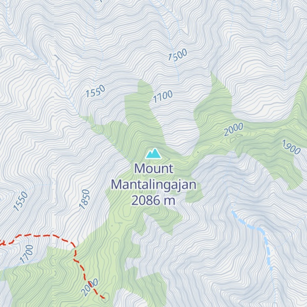
Mount Mantalingahan (or Mantalingahan or Mantaling) is the highest mountain in the island province of Palawan in the Philippines, with an elevation of 6,844 ft (2,086 m) above sea level, its ranked 68th-highest peak of an island on Earth and 10th-most prominent mountain in the Philippines. Located in the southern part of Palawan Island that forms the highest part of the Beaufort Mountains Ultramafics geological region, a series of ultramafic outcrops of Eocene origin, of which Mount Victoria forms the largest contiguous land area. The peak of the mountain is the highest point on Palawan island.
The mountain forms the center of the Mount Mantalingahan Protected Landscape (MMPL), a national park covering the entire Mantalingahan Mountain Range. The protected area status of MMPL was proclaimed on June 23, 2009, by virtue of Proclamation No. 1815. The protected area covers an area of 120,457 hectares (1,204.57 km2). The entire park is currently listed as a tentative site for UNESCO World Heritage Site inscription.
Continuing discoveries of new species of plant and animal from the mountain highlight its tremendous ecological value and the importance of maintaining such protective zones in the face of constant logging and mining pressures. The pitcher plant species, Nepenthes mantalingajanensis, described in 2007, is named after the mountain itself. In May 2018, UNESCO formally began the process which would possibly declare the landscape a world heritage site by 2020.
By elevation Mount Mantalingajan is
# 1 out of 236 in Palawan
By prominence Mount Mantalingajan is
# 1 out of 236 in Palawan # 10 out of 3134 in Philippines # 10 out of 3031 in the Philippines
We use GPS information embedded into the photo when it is available.
3D mountains overlay
Adjust mountain panorama to perfectly match your photos because recorded by camera photo position might be imprecise.
Move tool
Rotate tool
Zoom
More customization
Choose which peak labels should make into the final photo and what photo title should be.
Next
Photo Location
Satellitte
Flat map
Relief map
Latitude
Longitude
Altitude
OR
Latitude
°'''
Longitude
°'''
Apply
Register Peak
Peak Name
Latitude
Longitude
Altitude
Register
Teleport
PeakVisor
This 3D model of Sagarmatha National Park in Nepal was made using the PeakVisor app topographic data. The mobile app features higher precision models worldwide, more topographic details, and works offline. Download PeakVisor maps today.
Download OBJ model
PeakVisor
The download should start shortly. If you find it useful please consider supporting the PeakVisor app.
PeakVisor for iOS and Android
Be a superhero of outdoor navigation with state-of-the-art 3D maps and mountain identification in the palm of your hand!