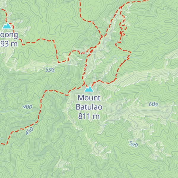
Mount Batulao is an inactive stratovolcano in the Calabarzon region of the Philippines, located in northwest Batangas province along its border with Cavite. It is a dissected andesitic stratovolcano at the northwestern rim of the Taal Caldera which began to form in the late Pliocene period, about 3.4 million years ago. The mountain is a prominent landmark of jagged peaks, rolling to rugged ridges and deep gorges situated just west of the hill station of Tagaytay at the southwestern end of the Tagaytay Ridge. It is well known for its scenery, as well as its retreat centers and resorts located just 85 kilometres (53 mi) south of Manila.
There's a demading hiking trail (T3) called New Trail leading to the summit. Mount Batulao is one of the 1 peaks along the Mt. Batulao New to Old Trail.
By elevation Mount Batulao is
# 8 out of 73 in Batangas # 1 out of 11 in Nasugbu
By prominence Mount Batulao is
# 4 out of 73 in Batangas # 1 out of 11 in Nasugbu
We use GPS information embedded into the photo when it is available.
3D mountains overlay
Adjust mountain panorama to perfectly match your photos because recorded by camera photo position might be imprecise.
Move tool
Rotate tool
Zoom
More customization
Choose which peak labels should make into the final photo and what photo title should be.
Next
Photo Location
Satellitte
Flat map
Relief map
Latitude
Longitude
Altitude
OR
Latitude
°'''
Longitude
°'''
Apply
Register Peak
Peak Name
Latitude
Longitude
Altitude
Register
Teleport
PeakVisor
This 3D model of Sagarmatha National Park in Nepal was made using the PeakVisor app topographic data. The mobile app features higher precision models worldwide, more topographic details, and works offline. Download PeakVisor maps today.
Download OBJ model
PeakVisor
The download should start shortly. If you find it useful please consider supporting the PeakVisor app.
PeakVisor for iOS and Android
Be a superhero of outdoor navigation with state-of-the-art 3D maps and mountain identification in the palm of your hand!