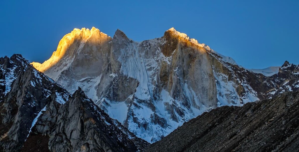
Meru Peak is a mountain located in the Garhwal Himalayas, in the state of Uttarakhand in India. The 6,660-metre (21,850 ft) peak lies between Thalay Sagar and Shivling, and has some highly challenging routes. The name Meru likely originated from the Sanskrit word for "peak".
The mountain was formerly the site of the world's highest BASE jump from a location on the surface of the Earth by Glenn Singleman and Heather Swan, from a height of 6,604 metres (21,667 ft), in June 2006, a record which has since been surpassed by Valery Rozov's 2013 jump from the North Face of Mount Everest.
The mountain has three distinct peaks: southern (6,660 metres; 21,850 ft), central (6,310 metres; 20,700 ft), and northern (6,450 metres; 21,160 ft). The two higher peaks were climbed earlier than the harder central peak, which was first climbed in a 2001 solo ascent by Valery Babanov, twice by other teams in 2006, and for the first time along the "Shark's Fin" route in 2011.
By elevation Meru Peak is
# 25 out of 56 in Gangotri National Park # 25 out of 70 in Bhatwari
By prominence Meru Peak is
# 24 out of 56 in Gangotri National Park # 28 out of 70 in Bhatwari
We use GPS information embedded into the photo when it is available.
3D mountains overlay
Adjust mountain panorama to perfectly match your photos because recorded by camera photo position might be imprecise.
Move tool
Rotate tool
Zoom
More customization
Choose which peak labels should make into the final photo and what photo title should be.
Next
Photo Location
Satellitte
Flat map
Relief map
Latitude
Longitude
Altitude
OR
Latitude
°'''
Longitude
°'''
Apply
Register Peak
Peak Name
Latitude
Longitude
Altitude
Register
Teleport
PeakVisor
This 3D model of Sagarmatha National Park in Nepal was made using the PeakVisor app topographic data. The mobile app features higher precision models worldwide, more topographic details, and works offline. Download PeakVisor maps today.
Download OBJ model
PeakVisor
The download should start shortly. If you find it useful please consider supporting the PeakVisor app.
PeakVisor for iOS and Android
Be a superhero of outdoor navigation with state-of-the-art 3D maps and mountain identification in the palm of your hand!