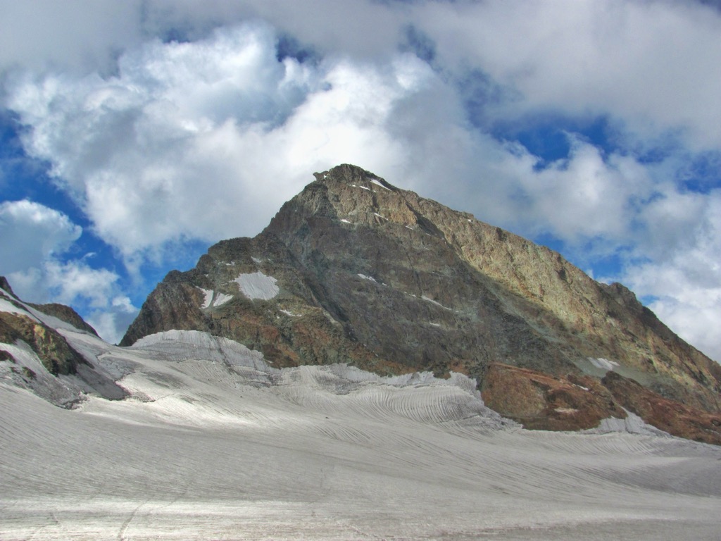
Kolahoi Peak (locally called 'Gashe-braed' meaning Illuminated Cat) is a mountain with peak elevation of 5,425 metres (17,799 ft) located in Lidder Valley, Jammu and Kashmir. Kolahoi Peak is easily accessible through Aru Pahalgam. The mountain is the highest mountain in Kashmir Division. Kolahoi Peak is part of the Great Himalayan range, and is located 16 km south of Kashmir. Accessible through the pathway of Aru Pahalgam, this mountain stands tall as the crowned jewel of the Kashmir Division.
Kolahoi Peak proudly claims its title as the highest peak in the Great Himalayan range.
From the icy embrace of Kolahoi's glacier emerges the lifeblood of the region, the Lidder River Pahalgam. Meandering southward, this tributary is a vital source for both drinking and irrigation in south Kashmir.
Kolahoi Peak rises from the Kolahoi Glacier is a pyramid-shaped peak with ice falls and ice fields at its bottom. The rock formation of the peak is extraordinary stable with aretes and ridges.
By elevation Kolahoi Peak is
# 1 out of 11 in Thajwas - Baltal Wildlife Sanctuary # 2 out of 39 in Pahalgam # 39 out of 596 in Jammu and Kashmir
By prominence Kolahoi Peak is
# 1 out of 11 in Thajwas - Baltal Wildlife Sanctuary # 1 out of 39 in Pahalgam # 4 out of 596 in Jammu and Kashmir # 35 out of 13857 in India # 54 out of 3458 in the Himalayas
We use GPS information embedded into the photo when it is available.
3D mountains overlay
Adjust mountain panorama to perfectly match your photos because recorded by camera photo position might be imprecise.
Move tool
Rotate tool
Zoom
More customization
Choose which peak labels should make into the final photo and what photo title should be.
Next
Photo Location
Satellitte
Flat map
Relief map
Latitude
Longitude
Altitude
OR
Latitude
°'''
Longitude
°'''
Apply
Register Peak
Peak Name
Latitude
Longitude
Altitude
Register
Teleport
PeakVisor
This 3D model of Sagarmatha National Park in Nepal was made using the PeakVisor app topographic data. The mobile app features higher precision models worldwide, more topographic details, and works offline. Download PeakVisor maps today.
Download OBJ model
PeakVisor
The download should start shortly. If you find it useful please consider supporting the PeakVisor app.
PeakVisor for iOS and Android
Be a superhero of outdoor navigation with state-of-the-art 3D maps and mountain identification in the palm of your hand!


_heighest_peak_of_Kashmir_Valley.jpg)


