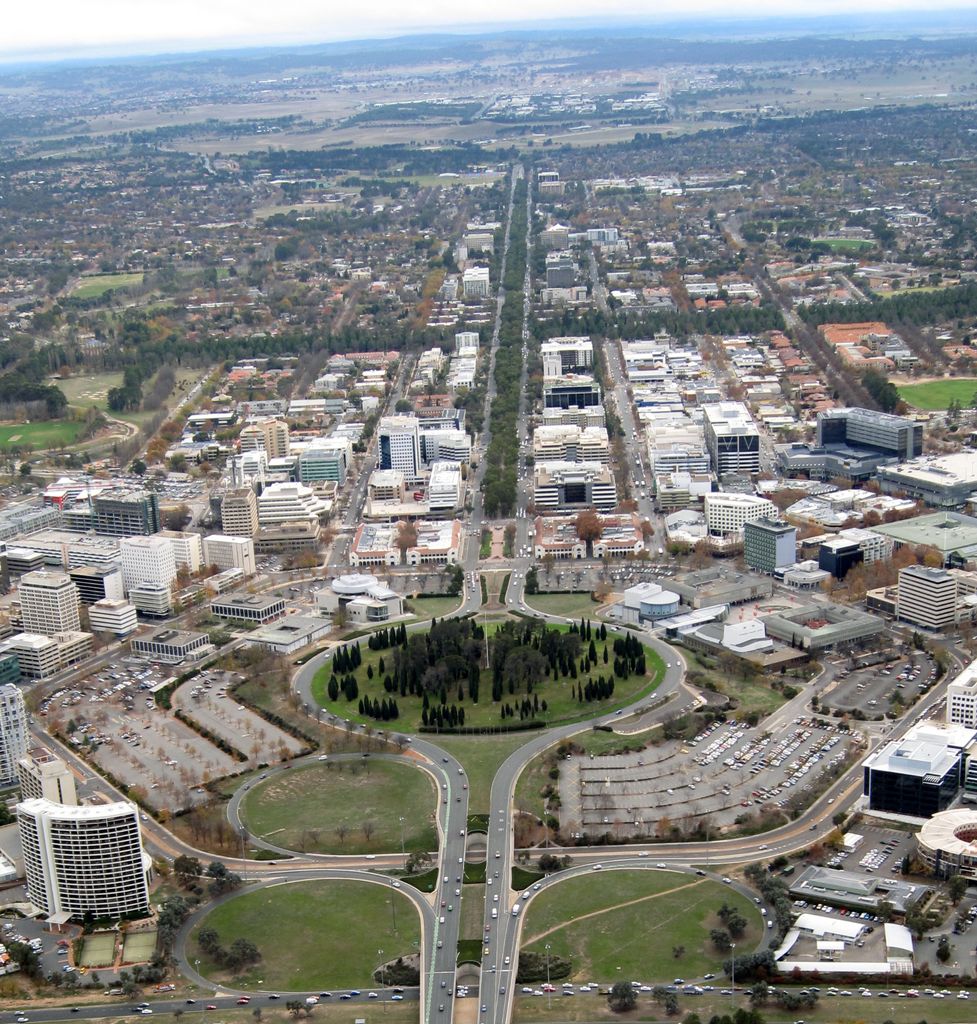
City Hill is a park located in Canberra, Australia, on one of the points of the Parliamentary Triangle, a feature of Walter Burley Griffin's plan for the city. The park is surrounded by Vernon Circle, at the south end of Northbourne Avenue, but beyond Vernon Circle it is further surrounded by the concentric London Circuit, and the area between Vernon Circle and London Circuit (which is partly built up) can also be seen as part of the hill. City Hill is an integral part of the city centre design. To the south of the hill Northbourne Avenue becomes Commonwealth Avenue, and further along is Commonwealth Avenue bridge.
The hill was planted in 1921. The design, supervised by Charles Weston, Canberra's first Superintendent of Parks and Gardens, was to emphasise the vistas along the six avenues radiating from the hill and reinforce the focus that Griffin placed on the hill as forming part of the Parliamentary triangle. At the centre of the hill is a flagpole flying the ACT flag since 1989 when the territory became self-governing. Immediately surrounding the flagpole are double staggered rows of closely spaced Roman cypresses (Cupressus sempervirens Stricta). Radiating outwards are twelve oval shaped groups of Roman cypresses and six groups of Monterey pines (Pinus radiata) reinforcing the symmetrical nature of the design. In 2014, the Canberra Centenary Column was added to the park, to commemorate Canberra's centenary.
The park is centrally located and well-known, but it is underutilised as it is away from shops and public areas and is difficult to access because it is surrounded by a major road. The prominent flagpole at the centre of Vernon Circle is not actually at the highest point of City Hill. The highest point of City Hill is to the south east, overlooking Lake Burley Griffin. Unusually for the centre of a large city and as a result of the relative isolation of City Hill, a small variety of mushrooms can be found growing under the pine trees. The City Hill area also has a large population of rabbits.
We use GPS information embedded into the photo when it is available.
3D mountains overlay
Adjust mountain panorama to perfectly match your photos because recorded by camera photo position might be imprecise.
Move tool
Rotate tool
Zoom
More customization
Choose which peak labels should make into the final photo and what photo title should be.
Next
Photo Location
Satellitte
Flat map
Relief map
Latitude
Longitude
Altitude
OR
Latitude
°'''
Longitude
°'''
Apply
Register Peak
Peak Name
Latitude
Longitude
Altitude
Register
Teleport
PeakVisor
This 3D model of Sagarmatha National Park in Nepal was made using the PeakVisor app topographic data. The mobile app features higher precision models worldwide, more topographic details, and works offline. Download PeakVisor maps today.
Download OBJ model
PeakVisor
The download should start shortly. If you find it useful please consider supporting the PeakVisor app.
PeakVisor for iOS and Android
Be a superhero of outdoor navigation with state-of-the-art 3D maps and mountain identification in the palm of your hand!