
Scan the QR code and open PeakVisor on your phone
Shuangliu National Forest Recreation Area has 5 named peaks. The highest is Maozi Shan at 696 m. Other notable peaks include Pozhugu Shan, Qigubalinshandongfeng and Taiheshan.
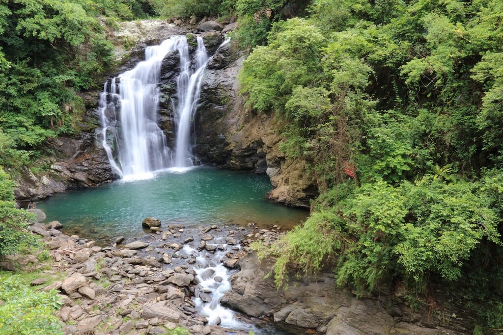
Home to a grand 25-metre (82 ft) waterfall, a flourishing wilderness of overgrown forest, elaborate displays of hanging prop roots from banyan trees, rich stream life, and exquisite butterfly watching opportunities, Shuangliu National Forest Recreation Area (雙流國家森林遊樂區) is a stunning protected area located in the southern part of Taiwan.
There are five named mountains in this recreation area. The highest mountain is Maozi Shan (帽子山) at 696 metres (2,283 ft); however, Qigubalin Shan Dongfeng (耆古巴林山東風) is the best-known mountain in the region at 556 metres (1,824 ft) in elevation.
Shuangliu National Forest Recreation Area is situated in the southern Hengchun Peninsula, of Shihzih Township, in the Pingtung County (屏東縣) of Taiwan. The forest area covers 1.6 sq km (0.6 sq mi) of land between about 175 to 650 metres (574 to 2,133 ft) above sea level.
Kenting National Park (墾丁國家公園), the southernmost national park in Taiwan, is located to the south of Shuangliu, and the Taiwan Strait (臺灣海峽) is located just to the west. To the east of the forest lies Xuhai Guanyinbi Nature Reserve (旭海觀音鼻自然保留區), which sits on the coast of the Pacific Ocean, while the Jinshuiying Historic Trail (浸水營古道) stretches north of the woods.
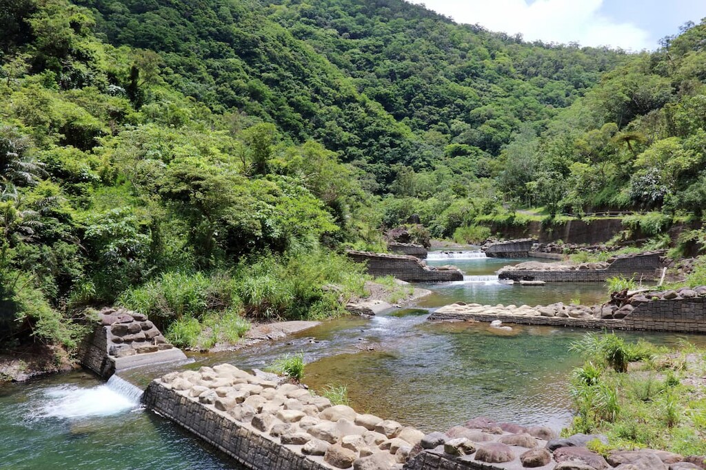
The name “Shuangliu” can be translated as “two streams.” This refers to the two rivers of the Shuangliu River and Neiwen River, both of which merge with the upper reaches of the Fenggang River at the majestic Shuangliu Waterfall.
The rivers serve as the most crucial recreation resource of the area, as visitors can bathe in the waters and observe life in the clear unpolluted waters of the streams. During the rainy season between October and April, waterfalls can be witnessed throughout the area, temporarily spilling down the mountain walls.
For this reason, the Mountainside trail has four exits to allow for quick evacuation should the river drastically rise due to flooding.
The average annual temperature of Shuangliu is 70°F (21°C) which is slightly low for a subtropical region; however, the shady dense forests and cold waters of the region’s surging rivers helps moderate the recreation area’s temperature, allowing cool breezes to rush through the valley.
Shuangliu National Forest Recreation Area is located on the Hengchun Peninsula, one of the youngest landscapes of Taiwan from a geological perspective.

While the steep, lofty mountains cutting along Taiwan’s backbone were formed through tectonic shifts, the gentler and generally flatter area of the Hengchun Peninsula was still submerged by ocean waters until the seas gradually receded, uncovering the fertile land.
The hills of Hengchun, which include parts of the Central Mountain Range, are composed of dark grey to black solid rock slate, phyllite, greywacke sandstone forming alternate layers in the mountain rock with a smattering of marlstone conglomerate.
The smooth terrain of the hills in Shuangliu National Forest Recreation Area consists of a generally precipitous nature. It features hilly slopes with a 30 degree gradient which rise on either side of the valley, the lowest point of the forest area.
In addition to Maozi Shan (帽子山) and Qigubalin Shan Dongfeng (耆古巴林山東風), the three other mountains found in Shuangliu are Pozhugu Shan (婆豬古山), Taihe Shan (太和山), and Qigubalin Shan (耆古巴林山).
Shuangliu National Forest Recreation Area's vegetation consists of a tropical monsoon rainforest unique to southern Taiwan. Due to the mild average temperature and intense humidity of the Hengchun Peninsula, it is the perfect climate to cultivate large quantities of ficus trees that fill the rainforest with remarkable features such as prop roots and blossoming tree trunks.
Flowering plants, such as the deep purple Dianella ensifolia, pink string of Alpinia zerumbet, the quaint blossoming posy of pure white and intense pink Hoya carnosa, and the endemic periwinkle blue Torenia concolor lindley var. formosana add pockets of colour to the trails.
The Central Mountain Range (中央山脈) blocks moisture from northeast monsoons between October to April, forming robust and dry foehn winds sweeping across the forest, cultivating the appearance of deciduous species as a standard feature in the forest’s vegetation, such as autumn maple.
During winter, the downhill winds influence warm temperate Fagaceae plants, such as Taiwan beech. Moraceae and Lauraceae plants, like the ficus and camphor tree, dominate the natural forests as these plants grow in both the low-lying valley and high mountain ridges.
The plentiful and diverse herbivorous and nectar plants, such as Stachytarpheta jamaicensis and the endemic Aristolochia foveolata, attract massive presence of butterflies in and around the forest. The saplings found on Griffith's ash are feeding sources for beetles, such as Dorcus titanus, and Parapoliybia varia.
More than 140 butterfly species have been recorded, the most prevalent being swallowtails and chestnut tiger butterflies. Overwintering crow butterflies also gather in the leeward valley every winter, feeding on Ficus plants and red nandina.
As the riverways are the essential feature of Shuangliu National Forest Recreation Area, there is a thriving marine life in the flowing streams. Geothelphusa albogilva, Japanese tree frogs, and the endemic Odorrana swinhoana occupy the clear unpolluted waters of the Neiwen. At the same time, Candida barbata and Sicyopterus janonias swim in the icy cold waters.
A total of 77 bird species have been spotted in the forest area, such as the crested serpent eagle, Taiwan blue magpie, and Taiwan hwamei. Birds that frequent the stream searching for food are the purple howling thrush, lead waterthrush, and kingfisher.
The rich and diverse forest is also a nurturing environment for mammals such as the Taiwan macaque, pangolin, wild boar, and brown lion cat.
The Paiwan people were the earliest inhabitants of southern Taiwan, They lived within what is now in Pingtung County and the southeastern area of Taitung County.
Paiwan dwellings were built throughout the mountainous regions of the island and they were mainly composed of slate; however, the old homes found around Fenggang Creek and the nearby rivers of Shuangliu do not feature slate.
The Paiwan dwellings in Shuangliu features a low wall of shale forming the base, with bamboo creating the walls, with a curved thatched roof resembling the tortoiseshell.

The standard feature of Paiwan homes is that local materials are used in the construction of the house, owing to the resourceful and adaptive nature of the Paiwan people. Also, the traditional Paiwan homes were low-lying, as the Paiwan dug the house’s base into the mountain slopes, allowing cold winter winds to brush over the thatched roofs of the shallow houses.
Ancient relics, such as the low wall ruins of Tortoiseshell House, an old Paiwan abode, lies along the route of the White Banyan Trail.
Shuangliu National Forest Recreation Area is home to four hiking trails, each of which offers a unique experience.
Once voted as the second most beautiful waterfall in Taiwan, the towering 25-metre (82 ft) waterfall is shrouded in mist as powerful water surges down the mountain wall. The Shuangliu Waterfall Trail is the main trail in Shuangliu National Forest Recreation Area, as two shorter tracks stem from the route of this trail.
From the start of the trail after the visitor centre to the grand ending at Shuangliu Waterfall, this moderately easy trail spans 3.2 km (2 mi). The trail runs along the Fenggang River in the valley.
As visitors stroll along the track, they cross the Fenggang River, using the sizable cylindrical stepping stones or otherwise wading in the ankle-deep water if they so desire.
The last 1 km (0.6 mi) of the Waterfall Trail starts to increase in incline as it enters a broadleaf forest of Formosan ash after crossing the arched Rainbow Bridge, allowing visitors to observe marine life in the clear streams.

The gushing waters of the Shuangliu Waterfall produce a whopping 9,350 negative ions. These negatively charged ions are believed to promote physical and mental health as they increase oxygen flow to the brain to combat drowsiness and accelerate mental energy. Also, these ions are known to reduce blood pressure, improve concentration, and enhance better sleep.
The beauty of the Shuangliu Waterfall is magnificent as the roar of the abundant water crashes into the river, forming a fresh sea of mist suspended in the air. The luxurious tropical rainforest cloaks the waterfall area in an opulent coat of rich emerald living green.
Returning from the waterfall, one can change paths to the White Banyan Trail of Mountainside Trail.
A flight of wooden steps leads into the 2 km (1.2 mi) White Banyan Trail (a.k.a. the Bairong Trail), that features a cluster of striking ficus trees, otherwise known as the fig tree or banyan tree. A diverse selection of Ficus are dispersed along this trail, such as Ficus superba, Ficus variegata, and Ficus benjamina.
Visitors follow the hilly path on this fairly challenging trail set on a steep incline assisted with rope walks. At 0.9 km (0.5 mi), the trail descends, unveiling the warped display of vertically hanging prop roots of banyan trees adorned in white bark.
Large groups of banyan trees imposingly stand in the forest as their prop roots touch the forest floor, connecting the trees into one extensive network as the roots link, warp, twist, and join, forming a colossal community of banyan trees.
The ancient relic of the Tortoiseshell House is also found on this hike, adding a historical element to a trail that is already adorned by a dense collection of banyan trees.

The Mountainside Trail follows a 2.2 km (1.4 mi) path along the waterfall slopes, where a chorus of singing cicadas merrily chime away. The trail runs parallel to the Shuangliu Waterfall Trail below in the valley.
The Mountainside Trail is the alternate route to the waterfall if the Waterfall Trail is flooded from the Neiwen River, which surges dramatically through the valley. There are four exit points located along this trail, too, in order to aid serve as evacuation points should the river levels drastically rise during your hike.
Additionally, situated in the middle section of this trail is a suspension bridge that affords lustrous views overlooking the thick forest cover, offering an entirely different perspective from the shady, damp trails below.
This area is also known as the best place to observe the many butterflies that flit around the forest. The Eulopea tulliolus butterfly occupies this area as it falls within its migratory route.

The peak of Maozi Shan received its name as it resembled the shape of a hat, which translates as màozi (帽子) in Chinese. For those interested in climbing the peak, the Maozi Shan Trail of 2,850 metres (9,350 ft) gently ascends to 696 metres (2,283 ft) above sea level.
The wooden path features rope barriers to assist climbers. The whole trail is dense with foliage with cool forest air drifting through the mountain trail.
Indeed, the trail features both fragrant Eupatorium japonicum and Formosan elderberry, both of which attract a flurry of butterflies. Furthermore, while ascending Maozi Shan, visitors will often notice the unique species of the Formosan medinilla, Chinese aucuba, and champion oak trees near the peak.
Near the summit, the wooden pavilion situated on Maozi Shan offers phenomenal panoramic scenes of the thick forest and surrounding mountains. The viewing platform also boasts views as far as the Taiwan Strait to the west and the Pacific Ocean to the east.

The two cities closest to Shuangliu National Park are Kaohsiung and Taitung City. As visitors only need several hours to venture across the whole park, it’s more convenient to stay in one of these two well-connected cities, both of which offer great access to Shuangliu.
The largest port city in Taiwan, Kaohsiung is an exciting hub city located in the southern part of the island. It offers excellent outdoor opportunities, such as venturing up Shou Shan, which overlooks the harbour and the city skyline.
A short ferry ride from the harbour will transport you to Cijin Island, known for its fresh seafood that street food vendors merrily sell in abundance. One can observe amazing views of the city of Kaohsiung on this ferry ride.
The tranquil and serene Lotus Pond, which is also located in the city, is another beautiful sight to check out. At the pond, there are three independent pagodas that stand tall and proud, each offering a symbol of Taiwanese culture.
The Dragon and Tiger Pagodas are mesmerizingly imposing. They feature two seven-story pagodas with brightly coloured, animated, larger than life models of a tiger dragon at each entrance. To enter and exit each pagoda, one needs to pass through the fanged open mouth of the dragon and tiger.
Meanwhile, the Liuhe Night Market is a popular attraction for both locals and tourists. Set along the fluorescent streets in the Sinsing District, this market sells everything. This includes Taiwanese delicacies like pungent stinky tofu, slimy (yet delicious) spicy oyster omelettes, and the puffy clouds of bao buns, as well as clothes, electronic equipment, and sometimes even live animals, like fish. A visit to a night market is an absolute must to witness the nightlife and culture of Taiwan.

While Taitung City is not as much of a central hub as Kaohsiung, this city set along the east coast of Taiwan is famous for its rugged, untouched beauty and its relaxed, more casual pace of life.
Each year, the Taiwan International Hot Air Balloon Festival is held in Taitung around July and August. An incredible display of hot air balloons occupies the skies during this festival, adding bright globes of colour and quirky designs to the heavenly blue skies.
The Taitung Forest Park houses three lakes, and it is a wonderfully picturesque place to walk in nature, listening to the singing lullaby of the birds while the waves crash on the coast a short distance away. The views of the rushing river, blue ridge mountains and expansive ocean are simply astounding.
Just outside of Taitung City lies the famous eastern Taiwan landmark of Sanxiantai, an eight arched bridge resembling a sea dragon that links the tiny island of Sanxiantai to the body of Taiwan. The Amis people once inhabited Sanxiantai Island, but it is now uninhabited and it has since been converted into a nature reserve.
Three luxurious hot springs are located in Taitung City, affording you with the choice to unwind and soak in the thermal waters. These hot springs are Zhiben Hot Springs, Toyugi Hot Springs Resort and Spa, and Hoya Hot Springs Resort and Spa, so they may be worth checking out during your stay.

From Taipei, Hsinchu, Taichung, Chiayi, and Tainan, head on the express train or Taiwan High Speed Rail (HSR) to Kaohsiung Main Station where you should take the Kuo-kuang bus 1778 bound for Taitung City and alight at the Shuangliu stop. It is a 15 minute walk from the Shuangliu stop to the Shuangliu National Forest Recreation Area.
If coming from Taitung City, catch the returning Kuo-kuang bus 1778 to Kaohsiung, get off at the Shuangliu stop and walk to the forest area.
Alternatively, visitors may wish to hire a car or scooter from either Kaohsiung or Taitung City to get to Shuangliu National Forest Recreation Area. From Kaohsiung, the journey takes 1 hour and 20 minutes over a distance of 89 km (55 mi), while Taitung City is slightly closer to Shuangliu at 78 km (48 mi) over 1 hour and 15 minutes.
If visitors wish to travel to Shuangliu from Kenting National Park, doing so is fairly quick and easy. Indeed, the total journey is just 45 km (28 mi) in length and it normally takes no more than 45 minutes to reach the forest area.


The highest peak in Shuangliu National Forest Recreation Area is Maozi Shan, at 696 m.
Notable peaks in Shuangliu National Forest Recreation Area include Maozi Shan, Pozhugu Shan, Qigubalinshandongfeng, Taiheshan and Qigubalin Shan.


