
Scan the QR code and open PeakVisor on your phone
The Pilancones is a massif created from volcanic eruptions that happened over 12 million years ago. It constitutes the oldest part of Gran Canaria Island.
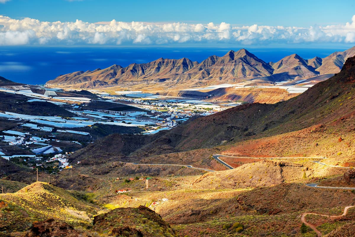
The landscape of the Natural Park is formed by brown sloping ravines, narrow interfluves, protected pine forests in the upper part, the tabaibal-cardonal (vegetal formation which comprises different kind of succulents) in the lowlands, the dragon trees, the blue waters of the dams and reservoirs of Ayagaures, the palm groves of Fataga and the curves of the road lading all the way to Tejeda and Roque Nublo, in the centre of the island. Not only are they the very definition of postcard perfect, but the whole park itself is of great interest to the scientific community.
Located in the municipality of San Bartolomé de Tirajana, this park has been a protected area since 1987 and is by definition an area of ecological sensitivity. Within the space of 60 sq.km., we can find the public mountains of Ayagaures and the Pilancones as well as protected zones for rare bird species.

This park is adjacent to the Nublo Rural Park and the Fataga Protected Landscape.
Due to its characteristics, the Pilancones Natural Park plays an important role in the maintenance and protection of island soils and in the recharge of its aquifer thanks to the ravines that run along its southern slope. These, in addition, make up a set of great natural and scenic interest. Along with its undoubted natural values, we can also find several vestiges of the passage of men through the Pilancones Natural Park.
The most notable of them is the archaeological site of the Guanche necropolis of Arteara, one of the largest in the entire archipelago in its category.
Throughout its geological history, it has undergone intense erosive processes that have shaped the terrain to its current appearance with embedded ravines and plateau interfluves that continue to erode. One of the best known in the area is the ravine of Fataga

Within its limits, there are some isolated villages, such as Lomo de Pedro Alfonso where you can see the well-preserved farming practices relying on very little irrigation. There are orchards to the south and west of the Park, with crops of mangoes, avocados or orange trees, which supply to a small extent the tourist centres in the south of the island. Also, in this area there are large water dams, such as the Ayagaures.
At the top, there is a pine forest with characteristics that are very suitable for bird populations, which is why a special protection area for the featheredе tribe has been included in the network
The Pilancones Natural Park is crossed by several paths of the Gran Canaria trail network. Through them, the main points of the protected complex can be covered on foot.
The Pilancones Natural Park borders the Roque Nublo Rural Park to the north and the Fataga Protected Landscape to the east, with which it forms a great natural unit. The most common access to Pilancones is via GC-60 road, which connects the towns of Maspalomas and San Bartolomé de Tirajana, crossing the Fataga ravine.

These are some popular trails in the area:
San Bartolomé de Tirajana - Degollada de La Manzanilla - Pilancones trail is a 13.4-kilometre-long loop trail near San Bartolomé de Tirajana. It has beautiful wild flowers and is rated difficult.
Pilancones - Tederas - Ayagaures trail is a 15.8 kilometre point-to-point trail located near San Bartolomé de Tirajana. It offers stunning panoramic views but the effort to get there is great as well. The trail is rated difficult.
Llanos de La Pez-Cruz Grande is a 6.8 kilometre point-to-point trail located near Tejeda. It offers scenic views and is good for all levels.
Hiking along the dams. This route is top-league mythical amongst the abundant hiking options in Gran Canaria, especially among those who enjoy long-distance hikes. Throughout its 12 kilometres, you will be able to see some of the most spectacular volcanic formations on the island: the Parque Rural del Nublo, the Pilancones Natural Park and the traditional cave houses. This hiking enclave in the Canary Islands begins in Degollada de Cruz Blanca and extends to the Soria dam, a four-hour route in which the culture and nature of the islands go hand in hand.

The peaks of the park have pine forest areas of great interest from a biological point of view. The pine forests of Inagua, Ojeda and Pajonales stand out. Furthermore, more or less isolated specimens of dragon tree, juniper and some endemic species such as tabaibales and cardonales can be found on the ground. Until 2008, the most important biological attraction of the park was the Pilancones pine, a tree of the Pinus canariensis species that was over 500 years old and was knocked down by a violent storm. It was catalogued among the hundred most unique trees in Spain. Even though it collapsed during a storm that hit Gran Canaria in 2008, it's clear that the effects of the fires that ravaged part of the centre of the island during the summer of 2007 played a major factor in its death.

Among the fauna of the place, birds such as the Canary Island linnet, the Great Spotted Woodpecker, the robin, the tit, the owl, the blue finch or the warbler stand out.
Most of these animals are concentrated in the pine forests. There are also large communities of reptiles such as the giant lizard of Gran Canaria.

The Park is located within the town of San Bartolomé de Tirajana, which is 54 kilometres away from the capital, Las Palmas de Gran Canaria.
It is the largest municipality on the island. Its mountain landscapes alternate with deep ravines and unfold to the beautiful beaches of its coastal coastline.

The municipality of San Bartolomé de Tirajana combines beach tourism with mountain tourism. From the coast to the highest part of San Bartolomé, there are 40 kilometres. The capital of the municipality is called Tunte, a place name that dates back to the settlement of an aboriginal town with the same name and a place where, after the conquest, various wanderers of Hispanic origin decided to settle. There, in the old part of the town, stands the Church of San Bartolomé de Tirajana, consecrated in 1922. The basilica of the Church is divided into three naves. The main altarpiece stands out, an artwork made in 1922 by the master Lino Feo Ramos. The central niche of the Altarpiece is occupied by the effigy of Saint Bartholomew, it was acquired between 1783 and 1787.
Tunte is located at the foot of the Morros del Pinar and next to the channel of the Tirajana ravine, at 890 m. a.s.l. Its privileged position in the heart of the Caldera de Tirajana has made it the main crossroads for communications between the north and the south of Gran Canaria. It justifiably boasts of being the ideal place for hiking. In its urban area, the blend of versatile historic heritage will keep you glued almost at every corner. You can virtually walk through history here.

Access must be made by the road GC-60 that connects Maspalomas with San Bartolomé, through Fataga.
In San Bartolomé de Tirajana:
In Maspalomas:
San Bartolomé de Tirajana:

In Santa Lucía de Tirajana:
In Maspalomas:


