
Scan the QR code and open PeakVisor on your phone
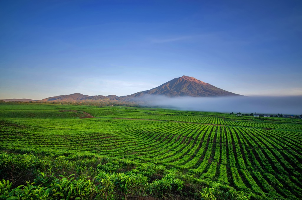
Kerinci Seblat National Park, on the island of Sumatra, is one of Indonesia’s 55 national parks, established in 1999. The park's main feature is its highest and most prominent mountain, Gunung Kerinci (3,805 m / 12,483 ft), one of the 35 active volcanoes in the Barisan Mountains range. In total, there are 251 named mountains in Kerinci Seblat National Park.
Kerinci Seblat National Park stretches across four Sumatran provinces: West Sumatra, Jambi, Bengkulu, and South Sumatra. At 13,750 square kilometers (5,309 sq. mi), it is by far the largest national park in Sumatra, almost twice as large as Gunung Leuser, the second-largest.
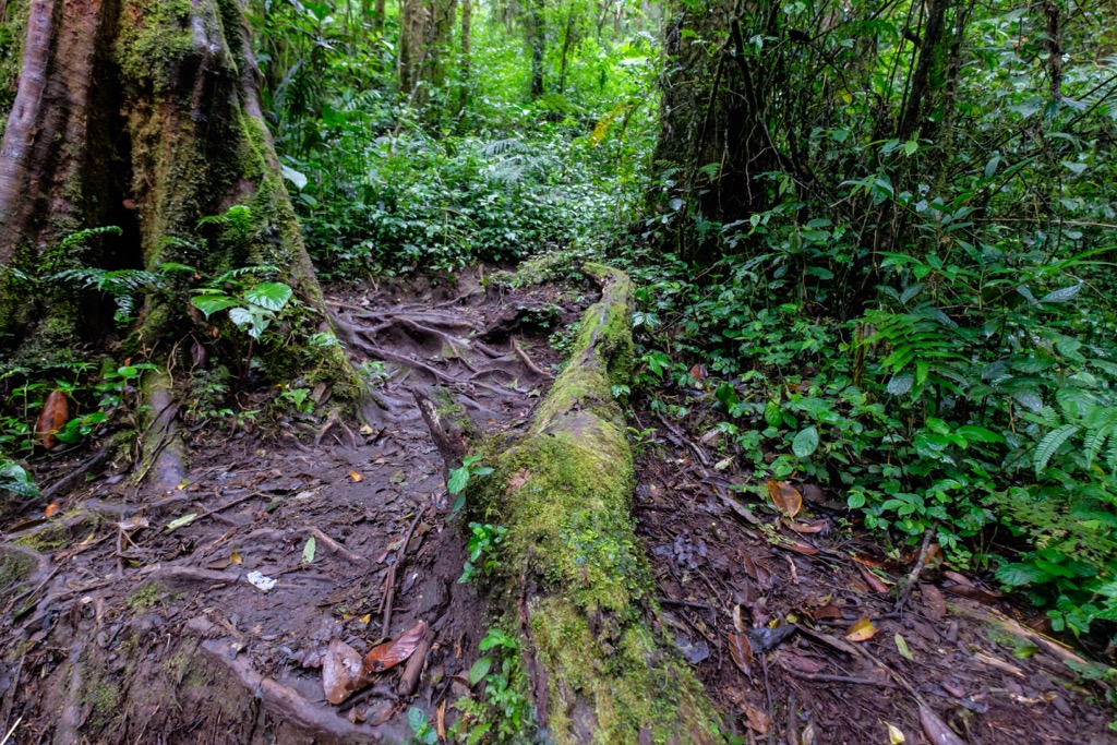
Along with neighboring national parks Bukit Barisan Selatan and Gunung Leuser, Kerinci Seblat National Park makes up the UNESCO World Heritage Site “Tropical Rainforest Heritage of Sumatra.” Its boundaries encompass a diverse topography, ranging from towering volcanic peaks to lowland rainforests. Seven forest types are present within the park’s boundaries (lowland, hill, sub-montane, lower montane, mid-montane, upper montane, and subalpine), as well as freshwater and peat swamps.
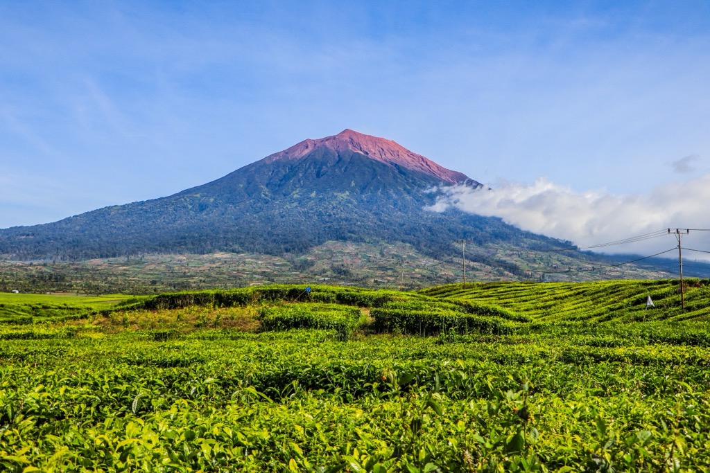
The park's centerpiece is Gunung Kerinci (3,805 m / 12,483 ft). Kerinci is not only the highest peak in Sumatra but also the highest volcano in Indonesia and anywhere in Southeast Asia. Kercini is Indonesia's second most prominent peak, after Puncak Jaya (4,884 m / 16,024 ft).
Other notable peaks in Kerinci Seblat National Park are Gunung Sumbing (2,507 m / 8,225 ft), Gunung Kunyit (2,151 m / 7,057 ft), and Gunung Tujuh (2,604 m / 8,543 ft). The park’s peaks are all members of the Bukit Barisan mountain range; it lies on the Great Sumatran fault, which results in a hotbed of volcanic activity.
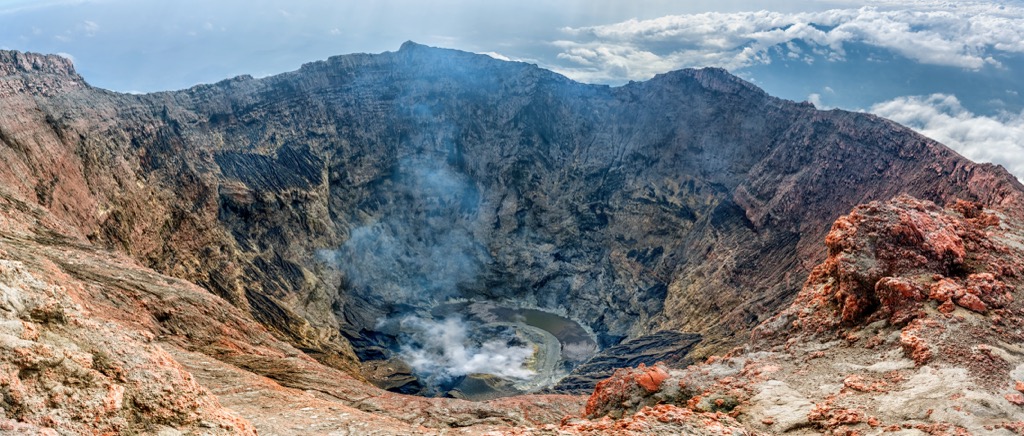
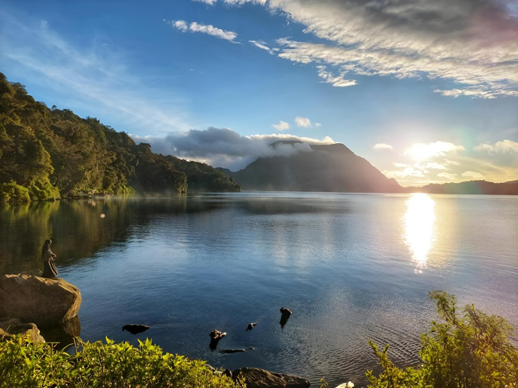
Kerinci Seblat is home to several famous high-elevation calderas (large volcanic depressions formed by the collapse of magma chambers). Of note is Danau Gunung Tujuh (Seven Mountain Lake). Ringed by the seven summits of the Tujuh volcano, the lake’s waters lie at over 2,000 meters (6,600 ft), making it the highest crater lake of its size in Asia.
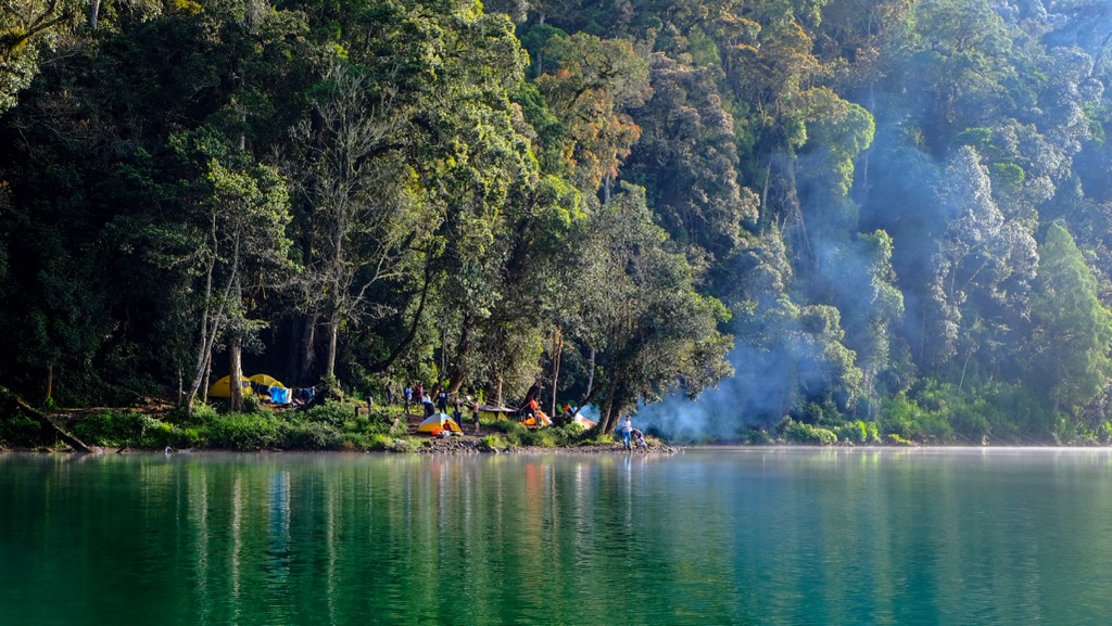
However, the most famous lake in the park is likely Lake Kerinci, below the slopes of Gunung Raya (2,543 m / 8,343 ft). This lake covers 42 square kilometers (16 sq. mi) and is over 100 meters (330 ft) deep. The lake is particularly significant due to the number of stone megaliths discovered in the villages along its shores, some of which date back over 2,000 years.
Temperatures vary significantly due to the park's dramatic elevation changes, ranging from steamy lowlands to the cool peaks of Kerinci. The lowlands typically average between 25-30°C (77-86°F) year-round, with high humidity and frequent rainfall. Though there are no significant seasonal variations in temperature, as elevation increases, temperatures drop. The highest elevations can reach as low as 5°C (41°F) or colder. These higher altitudes also experience more pronounced wet and dry seasons.
Rainfall is plentiful throughout the park, averaging 3,000-4,000 millimeters (118-157 in) annually. The wettest months typically occur between October and April, while the drier season runs from May to September. However, showers are common in the highlands, even during the dry season.
The Kerinci Seblat National Park lies within the Bukit Barisan mountain range, a chain of volcanoes that stretches along the western coast of Sumatra for almost 1,700 kilometers (1,056 mi). In addition to Gunung Kerinci (3,805 m / 12,483 ft), there are at least five active volcanoes within the park.
The Bukit Barisan range owes its existence to the action between the Indo-Australian and Sunda tectonic plates, a line known as the Great Sumatran fault. For over 100 million years, the Indo-Australian Plate has been subducting beneath the smaller Sunda Plate along the Java Trench, a deep-sea trench located off Sumatra's southwestern coast.
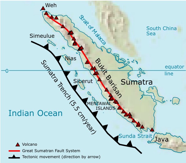
This subduction process generates intense heat and pressure, leading to the melting of mantle material and the creation of magma. As the magma rises through the overlying crust, it fuels volcanic activity throughout the boundary, resulting in a string of volcanoes known as the “Sunda Arc,” including the Bukit Barisan range, Gunung Kerinci, and the other peaks within the Kerinci Seblat National Park.
The volcanic history of the Bukit Barisan is punctuated by periods of intense activity and relative quiescence. The range's volcanoes are primarily andesitic to dacitic in composition, reflecting the partial melting of subducted oceanic crust and overlying mantle material. Volcanic products include lava flows, pyroclastic deposits, and volcaniclastic sediments.
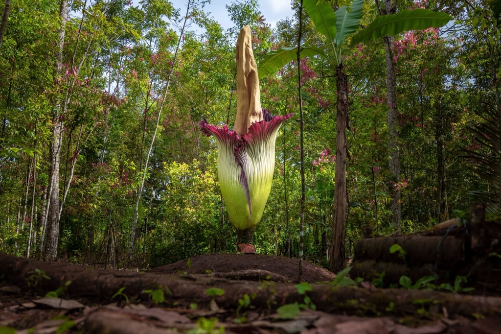
Kerinci Seblat National Park is home to a wide array of flora and fauna. The park harbors around 4,000 species of flora and is exceptionally diverse in species of orchids and tropical trees. It is home to both the world’s tallest and largest flowering plants. The former, the titan arum (Amorphophallus titanum), has flower clusters extending up to 3.3 meters (10 ft). The latter, the corpse flower (Rafflesia arnoldii), produces a single flower up to a meter (3.3 ft) in diameter, with the flower alone weighing up to 11 kilograms (24 lbs).
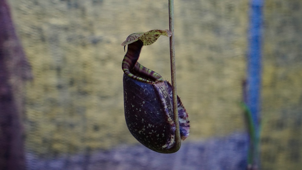
The slopes of the park’s Gunung Tujuh (2,604 m / 8,543 ft) are also home to one of just three wild populations of the critically endangered tropical pitcher plant Nepenthes aristolochioides. While there are many species of pitcher plants in the park, Nepenthes aristolochioides is notable as one of—if not the only—pitcher plants with a vertical opening.
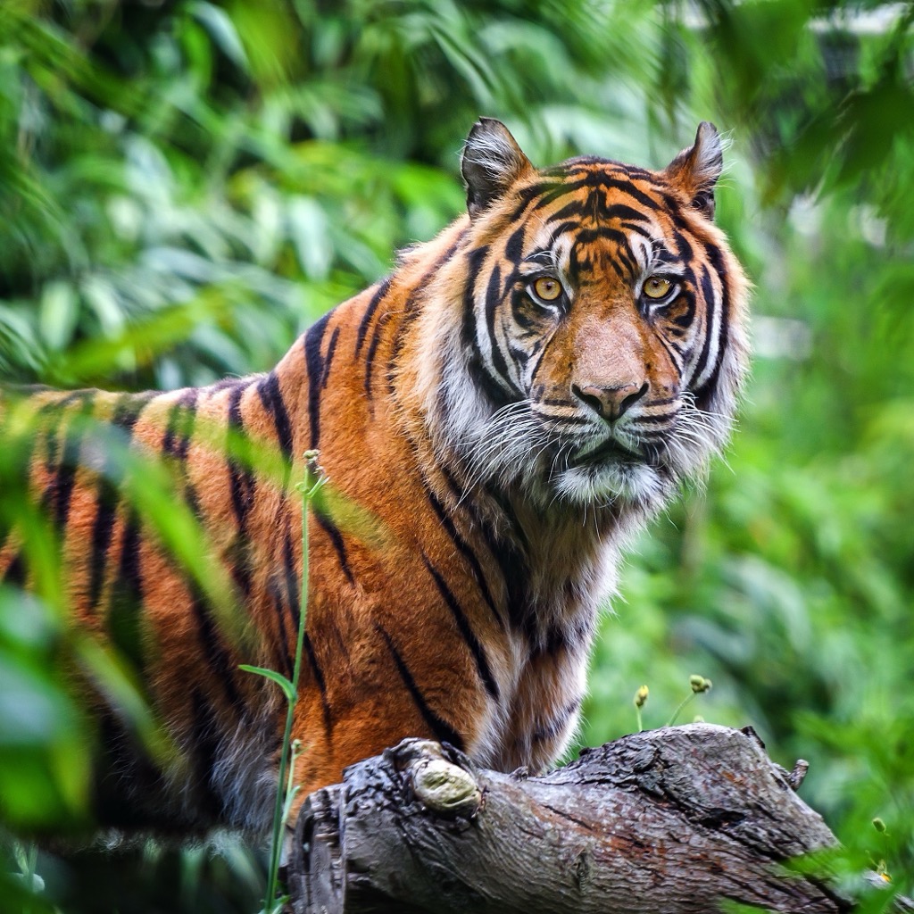
There are a staggering number of rare and highly endangered fauna in Kerinci Seblat. Still, perhaps the most significant is the park’s population of Sumatran tigers (Panthera tigris sondaica), which numbers around 150 to 200 individuals, of a total estimated population of around 500 on the entire island. The park is also home to several other feline species, including the leopard (Neofelis nebulosa), marbled cat (Pardofelis marmorata), leopard cat (Prionailurus bengalensis), and Asian golden cat (Catopuma temminckii).
Though there are no reported populations of critically endangered Sumatran orangutan (Pongo abelii), there are seven species of primates in the park, including siamang (Symphalangus syndactylus), black-crested Sumatran langurs (Presbytis melalophos), and southern pig-tailed macaque (Macaca nemestrina). Other notable mammals include the Malayan tapir (Tapirus indicus), Sumatran elephant (Elephas maximus sumatrensis), and slow loris (Nycticebus coucang).
As recently as the turn of the century, Kerinci Seblat had a large rhinoceros population, but the animals have since become extinct due to poaching. The Sumatran rhino (Dicerorhinus sumatrensis), the world’s smallest rhinoceros, was once found in rainforests, cloud forests, and swamps in nine countries, but today only remains in a few isolated pockets of Sumatra and one in Borneo (Kalimantan). The species is critically endangered, with a total population estimated at less than 80 mature individuals.
As of 2002, Kerinci Seblat has also been proven a habitat for the Sumatran muntjac (Muntiacus muntjak montanus), an extremely rare species of deer that had not been sighted since 1930. To date, there have only been two other photographs of the animal in Kerinci Seblat.
Kerinci Seblat is also particularly regarded for its avian life. The park protects over 375 bird species, including the critically endangered helmeted hornbill (Rhinoplax vigil), and 17 of Sumatra’s 20 endemic birds, such as the Schneider's pitta (Pitta schneideri), Salvadori's pheasant (Lophura inornata), and Sumatran cochoa (Cochoa beccarii).
The critically endangered Sumatran ground cuckoo (Carpococcyx viridis), believed extinct for nearly a century, was rediscovered in nearby Bukit Barisan Selatan in 1997, and in Kerinci Seblat in 2002. The foraging terrestrial bird is one of the world’s most endangered avian species, with a total population as low as 50 individuals.
The human history of the Kerinci Seblat National Park region stretches back to the Paleolithic era, and stone tools used by early hunter-gatherer societies have been found throughout the park. As these societies transitioned into the Neolithic, archaeological finds indicate a shift towards more settled communities, possibly engaging in early forms of agriculture and animal husbandry.
By 500 CE, the development of agriculture, particularly rice cultivation, led to the rise of early kingdoms in the region. The 7th century saw the influence of Hindu-Buddhist kingdoms from other parts of Sumatra and the wider archipelago, evident in the archaeological remains of temples and inscriptions. The mighty Srivijayan Empire, which flourished between the 7th and 14th centuries, further extended its reach over the region, facilitated by Kerinci Seblat’s strategic location along trade routes.
The 13th century marked the arrival of Islam in Sumatra, leading to the establishment of Islamic sultanates, such as the Aceh Sultanate, which emerged in the late 15th century and exerted significant influence over Sumatra and the surrounding region. The park area likely witnessed the interplay of Islamic and Hindu-Buddhist influences during this period.
European colonization began in the 17th century with the arrival of the Dutch East India Company, which exploited the region's natural resources and also saw the arrival of Javanese into the area—although the remote valley of Kerinci Seblat remained one of the last regions to be penetrated by the Dutch colonizers, with little contact made until nearly 1900. The following years saw the Dutch colonial administration exert greater control, leading to changes in land use and social structures, until Indonesia gained independence from Dutch rule in 1945.
Kerinci Seblat National Park was established in 1982 to protect the region's unique biodiversity and ecosystems, though its borders were only legally confirmed in the 1990s. Unfortunately, like much elsewhere in Indonesia, the park continues to face challenges caused by illegal logging, poaching, and encroachment. Tourists bringing economic stimulus via responsible ecotourism is a crucial way to demonstrate the value of this wilderness region to the local people.
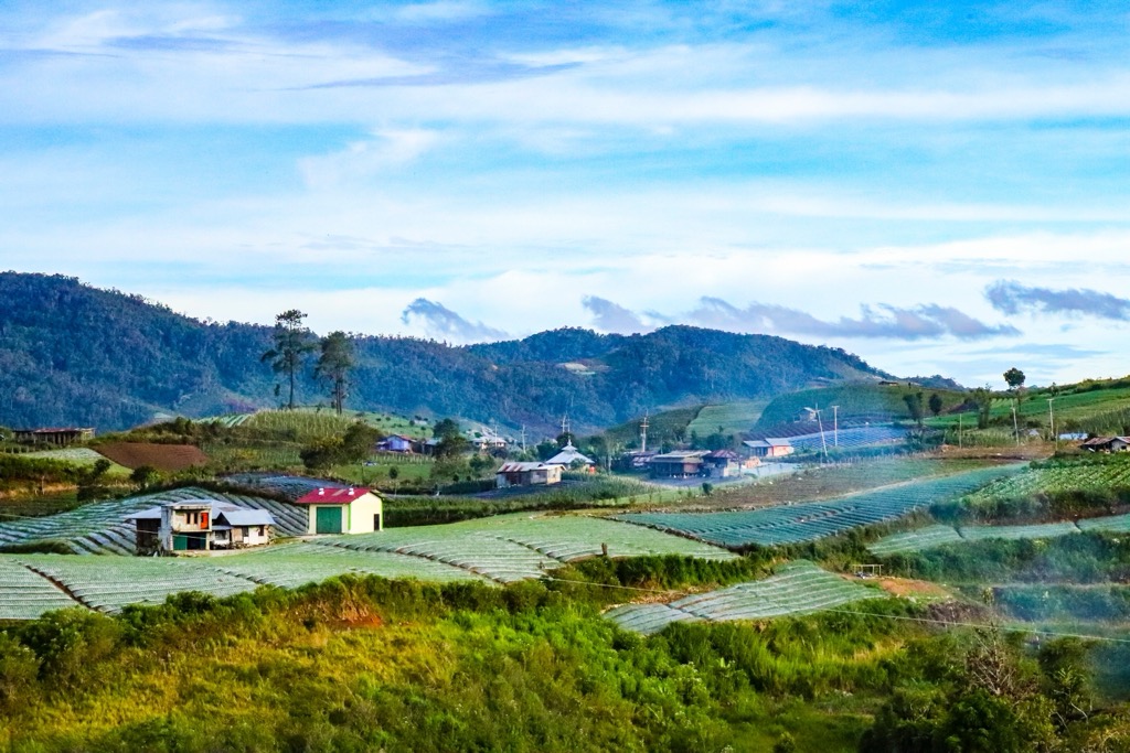
The 300,000 people who live in and around the valley of Kerinci Seblat today are extremely culturally and linguistically diverse, many times even from village to village. In the park's northern reaches, most tribes trace their lineage to the Minangkabau people of West Sumatra. In the south, populations are more indicative of the indigenous peoples of eastern and southern parts of Sumatra. Today, 95% of the region’s locals are farmers, using the rich volcanic soil to grow rice, cinnamon, cauliflower, potatoes, Arabica coffee, chilies, cabbage, and tea.
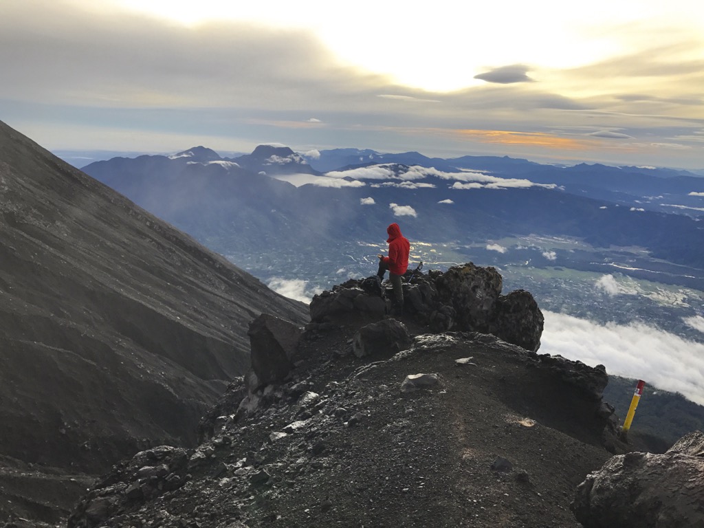
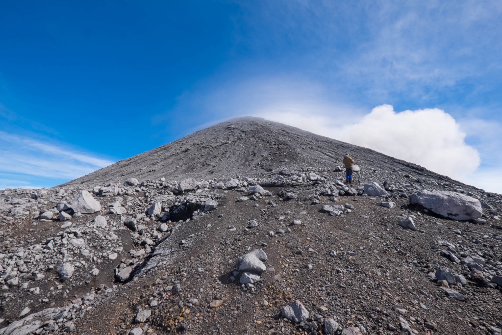
A trek to the summit of Gunung Kerinci (3,805 m / 12,483 ft), the second most prominent peak in Indonesia and the highest volcano in Southeast Asia, is undoubtedly the most exciting objective for experienced trekkers.
The established route, beginning in the village of Kersik Tuo south of the peak, is 17.9 kilometers (11.1 mi) round trip and entails 2,137 meters (7,011 ft) of vertical gain. Most parties take around 10 to 11 hours to complete this hike. It’s best done in the dry season, as the trail can become extremely muddy after rain. Start here: -1.767424504629917, 101.26617917822959.
For a mellower objective, try a hike to the Seven Mountain Lake (Danau Gunung Tujuh) below the apex of Gunung Tujuh (2,604 m / 8,543 ft). This trail leads to the highest caldera lake of its size in all of Asia, at an elevation of over 2,000 meters (6,600 ft).
The trail is 8 kilometers (5 mi) round trip, tackles 770 meters (2,526 ft) of vertical elevation, and takes most parties around four hours to complete, not counting time spent at the lake. This hike begins near the village of Pelompek. Start here: -1.7186392978957068, 101.36221041093211.
Gunung Kunyit (2,151 m / 7,057 ft), better known as “Turmeric Mountain,” is another stratovolcano that visitors can easily hike in a day. The summit comprises dual craters, the uppermost containing a crater lake. Kunyit can be hiked in a 15-kilometer (9.4 mi) round trip from Dusun Baru Lempur (-2.2616854743092834, 101.52987610095393). The path climbs 1,435 meters (4,708 ft) and takes most parties around eight hours.
There are many small villages and towns around Kerinci Seblat National Park, but foreign tourists will come overland from the cities of Padang (most common) or Jambi.
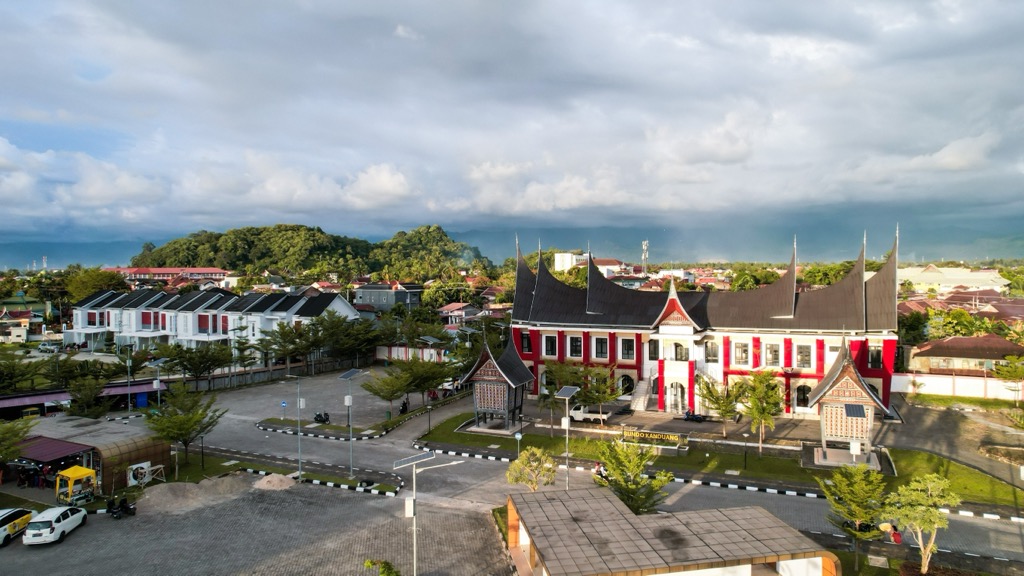
Padang, the vibrant capital of West Sumatra Province, boasts a population exceeding 900,000 and is around eight hours by car (north) from Kerinci Seblat National Park. Nestled along the picturesque coastline of the Indian Ocean, Padang offers a blend of nature, cultural heritage, and delectable cuisine.
A prominent landmark in Padang is the Adityawarman Museum, which houses a remarkable collection of Minangkabau artifacts. Visitors can admire intricate traditional textiles, ceremonial objects, and architectural models.
Another must-visit attraction is Air Manis Beach, renowned for its legendary Batu Malin Kundang, a rock formation said to resemble a kneeling boy cursed for his disobedience. The beach offers stunning views of the Indian Ocean and is a popular spot for swimming, sunbathing, and enjoying the sunset. The nearby islands of Mentawai also offer world-class surfing opportunities, with consistent swells and pristine beaches.
Padang is a culinary haven celebrated for its mouthwatering Padang cuisine, characterized by rich flavors and generous use of spices. Rendang, a slow-cooked beef curry, is a national dish of Indonesia. Other popular dishes include sate padang, grilled meat skewers served with a spicy peanut sauce, and nasi padang, a platter of rice accompanied by various curries and side dishes.
Jambi, the capital of Jambi Province, is a bustling city with a population of over 600,000 and is 10 hours by car from Kerinci Seblat National Park. Jambi is situated along the banks of the Batang Hari River, which is the longest in Sumatra.
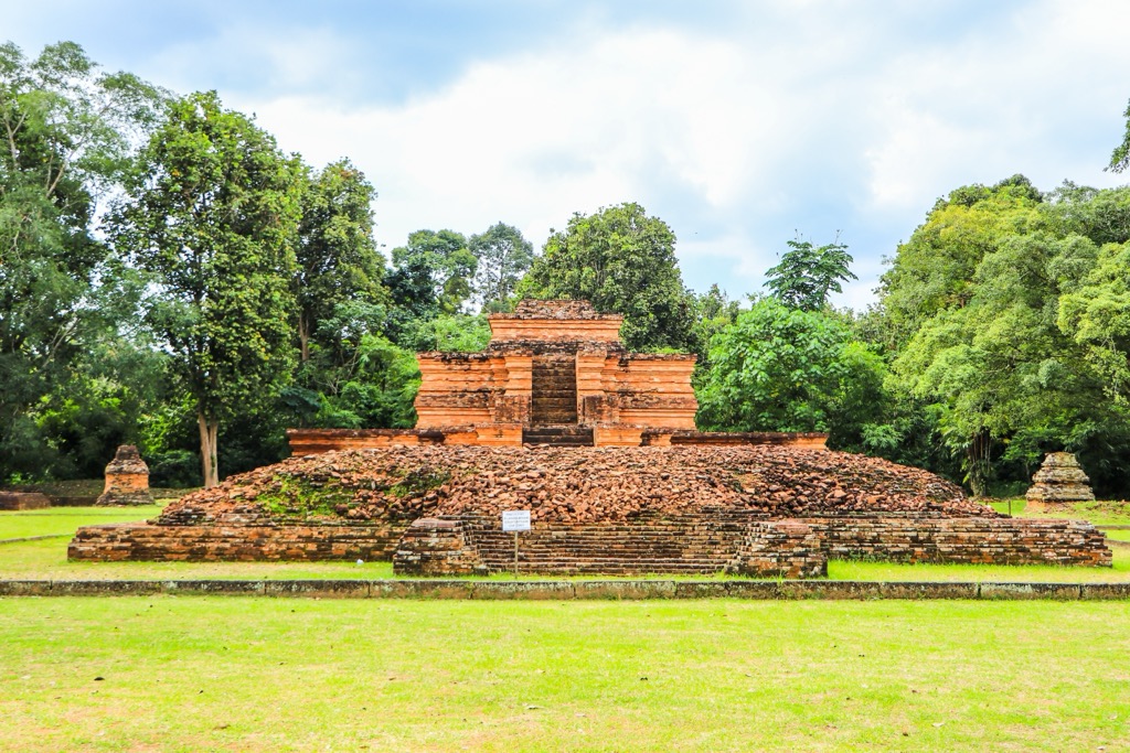
Jambi, a major center for rubber and palm oil production, is also known for its traditional crafts, including batik textiles and woven baskets. One of the most notable sights around the city is the Muaro Jambi Temple Complex, a sprawling archaeological site believed to have served as a major center of Buddhist learning and pilgrimage during the Srivijaya Empire. The complex comprises eight temple sanctuaries and dozens of mounds scattered across a vast area.
Another must-visit attraction is the Gentala Arasy Bridge, a pedestrian bridge that spans the Batang Hari River. The bridge's unique architecture, resembling a giant harp, has made it a popular landmark and offers stunning views of the river and the city skyline. Jambi is also known for its vibrant culinary scene; be sure to try tempoyak, a fermented durian dish, and gulai ikan patin, a flavorful fish curry.


