
Scan the QR code and open PeakVisor on your phone
Inner Mongolia is home to 761 named mountains. The highest is Aobaogeda at 3,556 m.
What are you imagining when thinking of Inner Mongolia? The vast grasslands and the vast blue skies? Thundering horses and scattered yurts? Flocks of sheep and cattle? Or the warrior-emperor Genghis Khan? The reality might be totally different from what you are envisioning.The twenty-first century Inner Mongolia (Standard Mandarin: Nèi Měng Gǔ) is a rather industrialized, prosperous and modern Chinese province, but due to the large size of the land you can still find the places of your dreams amidst the glimmering sand dunes of the Badain Jaran Desert and the vast grasslands in the north.
The Inner Mongolia, officially the Inner Mongolia Autonomous Region or Nei Mongol Autonomous Region, is a Mongolic autonomous region in Northern China. The long and narrow land of the region stretches from northeast to southwest, and is mostly a plateau averaging about 1,200 meters in altitude, bearing a variety of landforms such as plateaus, uplands, hills, plains, deserts, rivers, and lakes. The northern part consists of the Mesozoic Khingan Mountains, and is more forested chiefly with Manchurian elm, ash, birch, Mongolian oak and a number of pine and spruce species, because of the cooler climate. The Inner Mongolia runs across four major rivers, respectively the Yellow River, the Ergune River, the Nen River, and the Xiliao River.
In the extreme southwest, there is the edge of the Tibetan Plateau where the autonomous region's highest peak, at the same time the Main Peak in the Helan Mountains, Aobaogeda stands tall at 3,556 meters.
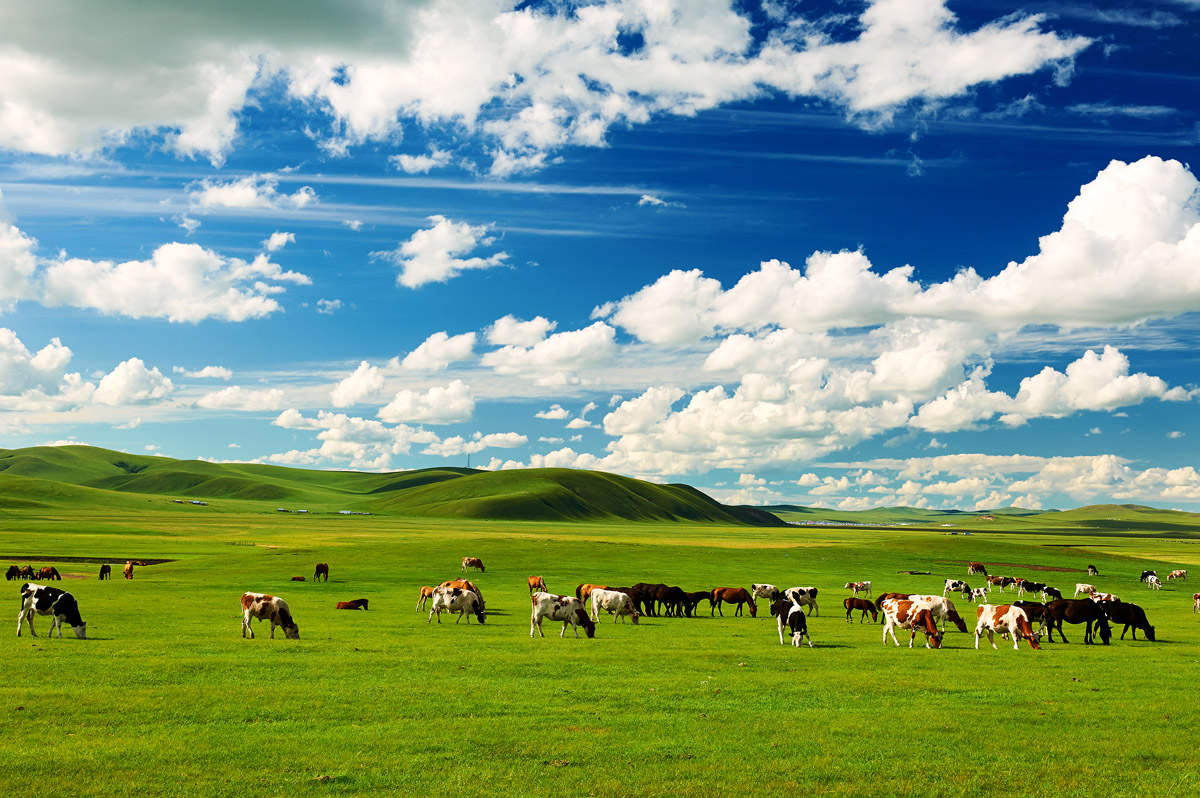
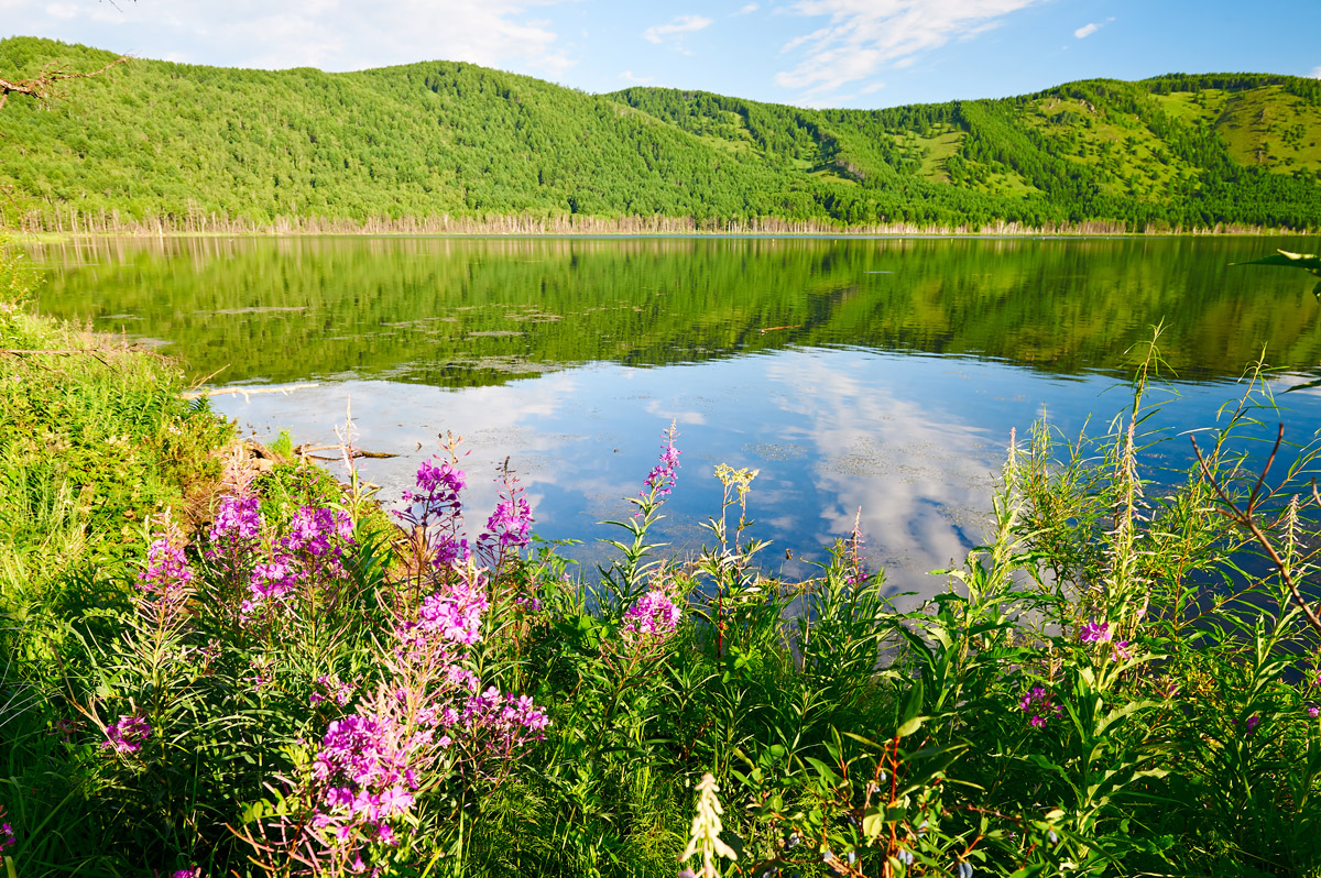
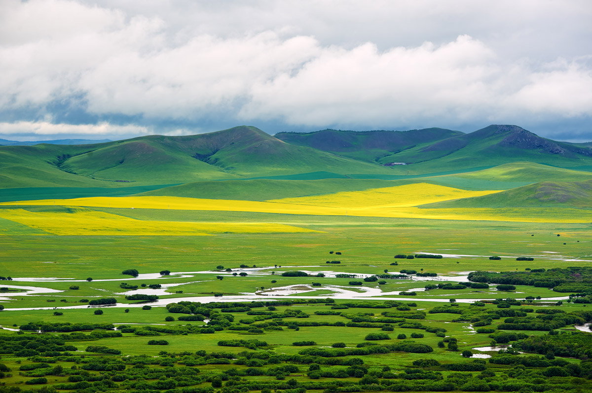
Located in the northeast of the Inner Mongolia and named after Hulun Lake and Buir Lake, the Hulunbuir Grassland is one of the best preserved grasslands in the world. The Hulunbuir Grasslands with a large area rich in beautiful scenery, lush plants, a dense network of rivers and lakes is one of the most popular tourist attractions in China.
The Hulunbuir Grasslands enjoy a wide network of hiking trails and scenic spots. Most trails start from Hailar District, Hulunbuir, where you can visit Hailar National Forest Park. The best time to visit is from June to September in the summertime, especially when the pasture flourishes in July and August and it is a great time for horseback riding and fishing in the middle of the prairie or having a boat trip on Hulun Lake in the west.
By Plane: There are five airports in Hulunbuir City, among which Hulun Buir Dongshan International Airport and Manzhouli Xijiao International Airport are the closest to the Hulunbuir Grasslands and the former is situated in Hailar District, Hulunbuir.
By Train: Hulunbuir is reachable directly by train from Beijing, Harbin, Shenyang, Qiqihar, Baotou, Dandong, Dalian, Chifeng and Tongliao to Hailar District, and 11 out of the 13 districts, county-level cities and banners in Hulunbuir are covered by the railway system.
By Bus: All the major towns of Hulunbuir are available by a coach.
The Tengger Desert with numerous trekking trails and scenic spots is a popular tourist destination for both passionate hikers and leisure tourists. As the fourth largest desert in China, the Tengger Desert has hundreds of virgin lakes that have been there for millions of years. Out of those many, Moon Lake and Swan Lake are famous and developed scenic spots. Besides, sand dunes, lake basins, saltmarshes, grass banks, mountains and plains distributed across the desert, allow views that are well-worth of a photo exhibition.
The Tengger Desert lies in the southwest part of Alxa Left Banner, the Inner Mongolia and in the border region of the central Gansu Province. The starting point of the hiking trails is around 100 kilometers away from the nearby city of Yinchuan. If you are not sure about the trails of where to wander in the dessert, a number of travel agencies and hiking clubs are available to provide trekking services and tours.
Zhongwei Shapotou, Tonghu Grassland and Moon Lake are popular tourist areas with developed infrastructure and entertainment facilities.
Note: Entertainment facilities charge extra fees. There are designated campsites in the scenic area and it takes about 200-300 RMB for camping.
Yinchuan: You can take a train to Yinchuan Railway Station and then transfer to a Yinchuan-Tengger Scenic Area bus. Or take a long-distance bus at Yinchuan Passenger Station to Shapotou, and get off at the Tengger Desert. It takes about 2 hours.
Bayanhaote: a car-drive from Bayanhaote to the desert takes 1 hour. Zhongwei City: drive from Zhongwei City to the desert. A taxi-drive takes about 50 RMB for a single trip.
Alxa Left Banner: From Alxa Left Banner, hire a car to the desert. It takes about 150 RMB for a one-way trip and 200 RMB for a round trip.
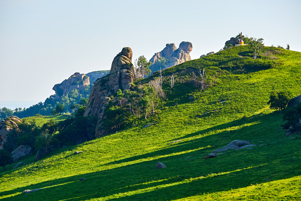
Arxan National Forest Park, an AAAAA tourist attraction of China, is located in the southwest of the Greater Khingan in the Inner Mongolia, as well as the center of the forest region of the Greater Khingan. It is noteworthy that Arxan Mountain is also at the junction of the Hulunbuir Grassland, the Xilingol Grassland, the Horqin Grassland and the Mongolian Grassland, which endorses the beautiful scenery in the area. But the Arxan volcano group has more than that, as it is the best known for the densest and the most alpine-looking crater lakes in the world. There are 7 Heaven Lakes and 40 lava-dammed lakes, offering a great feast for the eyes.
Besides the staggering volcanic lakes, you can also enjoy the rich natural views such as the geological relics of the Quaternary volcanic eruptions (Shitanglin), Rose Peak (Meiguifeng), Zhangsong Ling, the Halaha River (a famous ice-free river), Santanxia, the Arxan Grand Canyon, and hot springs. However, should you feel weary of the abundance of the natural scenery, the Arxan is also rich in places of historical and cultural interest including the abandoned airport, a railway station, and war relics.
The admission fee is 180 RMB per adult in high season from June to September, and 150 RMB in low season. The shuttle bus in the park charges independently 105 RMB for each adult or each child over 1.2 meters tall. Discounts and free offers are available for the aged, children, students and other special groups of people entitled to social benefits. Tickets are also available online at a discount.
8:00 a.m. - 5:00 p.m.
The best time to visit is actually all year round, but high summer season is more preferable because of the warmer weather. You will surely be surprised by how much the stunning views can vary as the seasons change.
* Please note that some scenic spots in the park may be closed in winter, usually for the sake of safety.
There is a convenient and developed transport system in and around the area. Arxan Yi'ershi Airport is situated 25.4 kilometers north of Arxan City, and services air travel to and from Beijing and Hohhot primarily. Planes also fly to Hangzhou, Harbin, and Ulaanbaatar, the capital of Mongolia, as well as many other locations.
The railway to Ulanhot (formerly known as Wang-um Sume or Red City) connects Arxan with Beijing, Tianjin, Hohhot, Shenyang, Changchun, Dalian, Harbin and other major cities in China.
There are several options you can choose from to cover the last few miles from Yi'ershi Town to the Arxan Park:
Remember to make sure the vehicle you choose will take you to your destination (it both concerns the petrol and the location point you need to get to) before you get into it.
Hexigten Global Geopark is a UNESCO Global Geopark in Hexigten Banner, Chifeng City, Inner Mongolia, China. Its 1,750-square-kilometer area is comprised of nine separate areas of scenic beauty and geologic significance, including volcanic, glacial, and desert features. The nine park areas are the Arshihaty Granite Forest (Asihatu Stone Forest), the Pingdingshan Scenic Quaternary Cirque Group, the Xilamulun River Canyon, the Qingshan Granite Mortars (Qingshan Yanjiu Scenic Spot), the Huanggangliang Quaternary Glacial Remnant, the Reshuitang Thermal Springs, the Dali Nur Volcanic Landscape (Dalinur Lake Scenic Spot), the Hunshandak Sand Land, and the Wulan Butong Grassland. Hexigten Global Geopark is actually a comprehensive and complex concept of the nine scenic spots as a whole, which allow a variety of experiences of leisure walks, exploratory mountain hikes, sightseeing trips, and geological research.
Asihatu Stone Forest: 120 RMB for the admission ticket and sightseeing bus within the park, excluding the sightseeing car.
Wulan Butong Grassland: 120 RMB for the admission ticket and sightseeing bus within the park, excluding the sightseeing car.
Qingshan Yanjiu Scenic Spot: 80 RMB for the admission ticket, 40 RMB for a one-way cable car trip and 80 RMB for a round cable car trip. A full ticket costs 120 RMB per person, including the admission ticket and a round cable car trip. The electric car costs 30 RMB extra per person.
Dalinur Lake Scenic Spot: The scenic spot is divided into two areas, the northern shore and the southern shore. The northern one charges 90 RMB for the admission tickets to the scenic spot in the north and the museum, including a sightseeing bus. The southern one charges 120 RMB for the two scenic spots of Mantuo Shan and Bihai Yintan Shallow, as well as sightseeing bus.
Moerdaoga National Forest Park in the Greater Khingan Range is a fairyland that you cannot afford to miss when you are planning your northeast Inner Mongolia tour. Moerdaoga is Mongolian literally meaning "to set out for a battle on a horse", and legend has it that the word was shouted out by Genghis Khan in 1207. The park is an AAAA tourist attraction in China, featuring the following scenic spots:
Long Yan Lan Sheng
Long Yan Lan Sheng means "visiting the scenic spot of Dragon Rock" in English. Located to the east of Moerdaoga Town, Longyan Mountain is 1,000 meters high and over 35 kilometers long from east to west. A 200-meter-long dragon-shaped rock lies on the west slope of the mountain and gives the mountain its name.
Da Han Ping Diao (Genghis Khan Park)
The 2,500-square-meter Genghis Khan Park is built on Longyan Mountain. The park presents an 18-meter statue of Genghis Khan riding a horse.
Hong Dou Po (Cowberry Slope)
Hong Dou Po sits 9 kilometers further into Moerdaoga National Forest Park, and is well-known for the cowberries growing all over the slope. Don’t get it confused with a famous manga series roughly translated as “The Battle through the Heavens”.
Yan Song You Jing (Path of Siberian Dwarf Pine)
This scenic spot is located 12 kilometers further into the park, taking up an area of over 1,900 hectares. It is called "the wonder of the Khingan" by ecologists for the unusually dense and wide growth of Siberian dwarf pines.
Yi Mu Jiu Ling (Nine Mountains at a Glance)
The viewing platform is at the top of a mountain that is 16 kilometers away from the entrance of the forest park. It allows staggering panoramic views of the whole Greater Khingan. Viewed from the top of the mountain, the mountains at a distance overlap and connect with each other.
Bailu Island
Bailu Island is a scenic location strongly recommended by many tourists. Surrounded by the Ergune River, the island grows a great number of white birch trees and presents beautiful colors in autumn. It is one of the favorite locations of photographers. 9-kilometer-long rafting is also provided for water sport enthusiasts.
The admission fee is 150 RMB per person. There is a cog railway in the park covering a journey of 10 kilometers in 90 minutes, it stops for several minutes at each of the four scenic spots. The cog railway service costs 100 RMB per person.
The Moerdaoga National Forest Park is located near Ergune City, Hulunbuir City, Inner Mongolia Autonomous Region, China.
You can go from Hailar to Moerdaoga Town by train or by bus. The forest park, which covers a very large area, is 12 kilometers away from Moerdaoga Town. There are more than 100 kilometers between the gate of the park and Bailu Island, without a shuttle bus provided. Therefore travelling in the park requires a car. You can hire one in Moerdaoga Town.
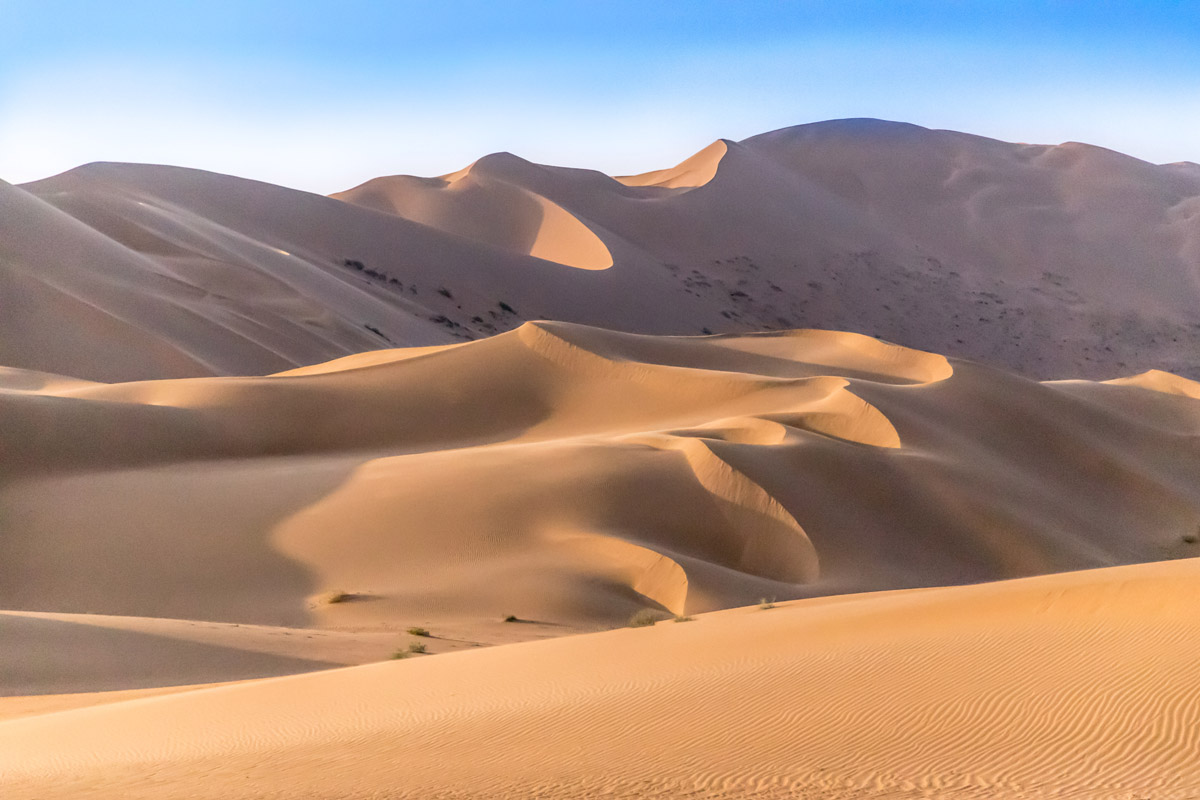
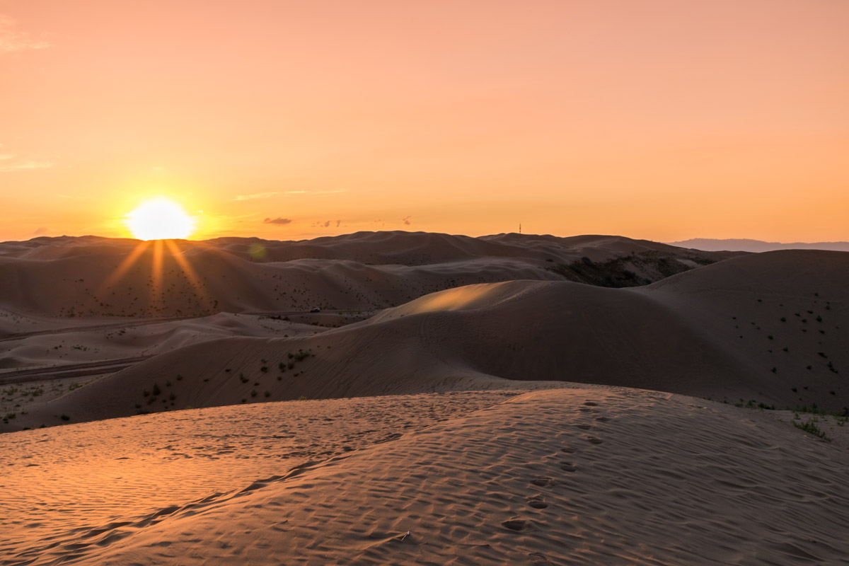
The Badain Jaran Desert covers an area of 49,000 square kilometers, featuring the stunning landscape of over 140 spring-fed desert lakes lying between the towering dunes. These lakes give the desert its name, which is Mongolian for "mysterious lakes". It is the biggest singing sand area in the world, also called “Singing Sand Kingdom”. The sound of the singing sand is like thunderclap or the roar of a plane. The sound is loud so that it’s heard even beyond 10 kilometers (6 miles). The desert is also crossed by the Ruo Shui (literally, weak water) River, which is also called the Ejin River. Regardless how weak it might have been, this river has formed an alluvial plain in the desert. Spanning the provinces of the Inner Mongolia, Ningxia and Gansu, the Badain Jaran Desert is the third largest desert in China by size, and is home to the tallest stationary dunes on Earth. Bilutu Peak (1,605m), the world's highest stationary dune rising over 500 meters, is reputed to be the Mount Everest of the Desert.
Badain Jaran Temple
The Badain Jaran Temple is a well-preserved Tibetan-Buddhist temple located in the middle of the desert. Built in 1868 (or 1755 in some sources) at the side of a lake, the isolated temple survives untouched and safe as time goes by. The size is impressive for an edifice in the no-man’s-land: it is 273.7 square meters (2,950 square feet) large and has two floors.
Bilutu Peak
Bilutu Peak (1,605m) is not only the world's highest stationary dune, but also the biggest one among the several large stationary dunes within the Badain Jaran Desert. Upon reaching the top you will be rewarded with a clear view of the surrounding dunes and colorful lakes.
The Khara Khoto Relic
Also known as the ancient black city, Khara Khoto is located in the northwestern side of the desert near the Ruo Shui River and lies fairly close to the new city of Ejin, only 25 kilometers to the southeast of Dalaikubu Town, Ejina Banner, Alxa League, Inner Mongolia. Founded in 1032, the ancient city with great history was once the center of the Tangut empire, the city flourished again after Genghis Khan conquered the city, but was in the end left abandoned and in ruins in 1372 during the Ming dynasty. It has been left untouched since then, and is now a place of interest accessible if you manage to find some transportation in from Ejin.
Badan Lake
Badan Lake Scenic Spot is situated at the south edge of the Badain Jaran Desert, and is the portal of the desert. It consists of 13 lakes, among which there is a freshwater lake that is uncommon in the desert. The lake looks like a graceful gem reflecting the surrounding dunes and plants, and makes a great place for camping on the lakeshore. The scenic spot is 92 kilometers away from Badanjilin Town and 50 kilometers from Yabulai Town.
The Badan Lake Scenic Spot charges 70 RMB for admission fee. If you want to go farther than the Badan Lake into the desert, the admission fee for the desert is 160 RMB per person.
In case you are not planning an extremely hard trek across the desert, you'll need to first head to the Alxa Right Banner (also known as Badanjilin Town) and hire a car and a driver, which costs from 2000 to 7000 RMB covering various journeys ranging from two to four days. The dispersed scenic spots in the desert, such as Bilutu Peak and the temple, are usually accessed by visitors renting a sand jeep in Alxa Right Banner. Only specific jeeps are able to drive through the desert, ascend and descend the sand dunes.
The closest town in the region, Alxa Right Banner, is a 30-minute drive from the dunes.
Neimenggu Helan Mountain National Forest Park at the foot of Helan Mountain is the place to go for enthusiastic hikers. Hiking in the mountains allows staggering views of the virgin forest that features some rare species of flora and also home to hundreds of wild animals such as musk deer, berghaan, foxes and dzeren (a very beautiful antelope that is now on the brink of extinction and is in the Red Book of Rare Species of Russia).
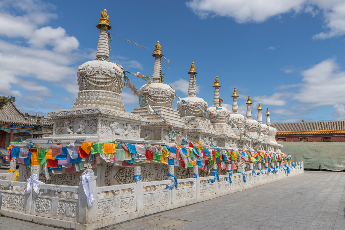
Helan Mountain is rich in hiking trails at various levels of difficulty and length. The trails starting from Fuyin Temple or Guangzong Temple are moderate, and buses are available to provide an easier method to ascend the mountain. Fuyin Temple (the north temple) Scenic Area and Guangzong Temple (the south temple) Scenic Area together make up the Helan Mountain National Forest Park in Inner Mongolia. The two biggest Tibetan-Buddhist temples in the western Inner Mongolia lie in the mountains, composing a landscape incorporating the beauty of both the nature and the culture.
Fuyin Temple Scenic Area charges 70 RMB for admission. Guangzong Temple Scenic Area admission fee is 80 RMB. A round-trip bus ticket is 30 RMB extra.
The two scenic areas are located in the Alxa Left Banner, Inner Mongolia, and can be accessed by a chartered car.
The Xiangshawan (literally translated as the Whistling Dune Bay) Desert Resort in the Dalad Banner, Ordos is China’s first desert-style resort and a 5A-level tourist attraction. Located in the easternmost part of the renowned Kubuqi Desert in China, the Whistling Dune Bay is a crescent dune with a height of 110 meters, a width of 400 meters and a gradient of 45 degrees. When “surfing” down a sand dune, one will hear the rumbling of sand. It may sound like the croak of frogs, the roar of cars or planes, a sudden clap of thunder or even a passionate symphony. The sand sings in a neat and interesting way.
The Xiangshawan Desert Resort is a well-developed and mature scenic resort, offering a number of desert entertainment facilities and projects such as cable cars, sightseeing trains, desert motorcycles, desert paragliders, sand surfing, and horse and camel riding. The whole desert resort has been divided into several areas to provide different experiences. The admission fee and cable car service total to 130 RMB per person. Different areas and the entertainment projects within the resort charge separately but a through ticket is available online.
It will take you about 50 minutes by taxi to get there from Baotou Airport or Baotou East Station.
Daoxugou Scenic Area belongs to the Qilaotu Shan mountain range that branches off from the Yan Mountains, and is located in the southwest corner of the Heilihe National Nature Reserve, Ningcheng County, Chifeng City, Inner Mongolia. The lush forests, crystal clear brooks, lakes and waterfalls, all contribute to a kingdom of flora and fauna to present the vitality and beauty of nature.
The admission fee is 80 RMB per person. There are electric sightseeing cars in the area that charge independently.
From Chifeng, you can go to Tianyi Town by bus or by train, and then transfer to a bus to Shantou Countryside. From Shantou you can take a taxi to the Daoxugou Scenic Area.
The Erguna Wetland lies on the northwest side of the Greater Khingan Range and on the east shore of the Ergune River. It is China's most intact and largest wetland, as well as a favorite destination for tourists and photographers. The Erguna Wetland Park is established at the corner of the Erguna Wetland to offer a relaxing scenic tour of leisure walks along the well-paved plank roads while having stunning views of the wetland from different angles.
In summer, the plants flourish on the wetland and this is the time when you should visit the place for the best scenery. The park is open from May to October each year. It is better if you confirm the accessibility before visiting.
65 RMB admission fee and 15 RMB for a round trip by electric sightseeing car, saving you a 4 kilometers' walk.
The scenic area is a short walk from the bus station.
The Kubuqi Desert is located in the north Ordor highland. "Kubuqi" means "bow" in the Mongolian language. This desert looks like a golden bow in the earth. It is the seventh biggest desert in China and the nearest to Beijing. Its main trails provide a moderate challenge for most outdoor enthusiasts and novices who want to have a nice desert hiking experience. A number of travel agencies and clubs can provide related tours. The highlight of this desert is the Resonant Sand Gorge located in the northeast side of the desert.
The best time to visit is in summer and autumn. May to October temperatures are quite high, always around 25 C to 40 C in the daytime, while at night, the temperature will drop to around 10 C to 15 C according to the weather. The Kubuqi Desert is quite safe to travel as it is rare to experience the sandstorm here.
Hailar District, Hulunbuir: It is the place to go to if you have plans for the scenic attractions on the Hulunbuir Grasslands. Hailar National Forest Park and Genghis Khan Square are also within the reach of the district.
The Hexigten Banner is rich in beautiful natural scenery such as the Asihatu Stone Forest, the Baiyin Aobao National Nature Reserve, the Gong Geer Grassland, the Huanggangliang National Forest Park, the Wulagai Grassland, and the Saihanba National Forest Park. You can even be all right to claim that the whole Hexigten Banner is a big scenic park. Stunning scenery can be enjoyed everywhere not only in some specific scenic area.
The Tumotezuo Banner, or Tumed Left Banner, is located in the center of the Inner Mongolia Autonomous Region. One of the noteworthy tourist destinations is the Hasu Sea, which is praised as "the West Lake outside the Great Wall". The other major attractions include: the magnificently built Lama Cave Temple, Guanghua Temple; the Jinluandian Ecotourism Area, an ideal summer retreat sitting at the top of Daqing Shan (2,270 m) and to the northwest of Guanghua Temple; and the Ming-Qing Architecture Expo Park, which combines ancient architecture, history, and culture.
The Alxa Right Banner (Badanjilin Town). The surrounding scenic areas are the Badain Jaran Desert, the Mandela mountains' rock paintings, Haisenchulu Wind Erosion Landform Scenic Site, and Eribugai Canyon.
Hohhot is a town famous for natural and cultural tourist attractions, it is the capital of the Inner Mongolia. The notable landmarks include:


Yes. Inner Mongolia has 761 named mountains. The highest is Aobaogeda at 3,556 m.
The highest mountain in Inner Mongolia is Aobaogeda, at 3,556 m.
Inner Mongolia has 761 named mountains.


