
Fresh snow · last 24 h
—cm
Upper-slope regional maximum
November 20 Snow Report
More mountains. More possibilities. Snow report coverage is expanding to Pyrenees.
Mountain intelligence by PeakVisor
No published Pyrenees report in this data set
—cm
Upper-slope regional maximum
—cm
Forecast regional maximum
—open
By calendar · check live lift status
—km/h
Forecast time not supplied
Loading regional snow map…
Each territory uses its own published time window.
Regional upper-slope model values. Select an area for its outlook. Values vary with elevation.
Snowfall is modeled, not a station measurement. Compare elevation, wind and the current official bulletin before choosing your mountain day.
Methods & sourcesForecast valid for Saturday, November 21
Published Nov 20, 08:15 PM GMT+1
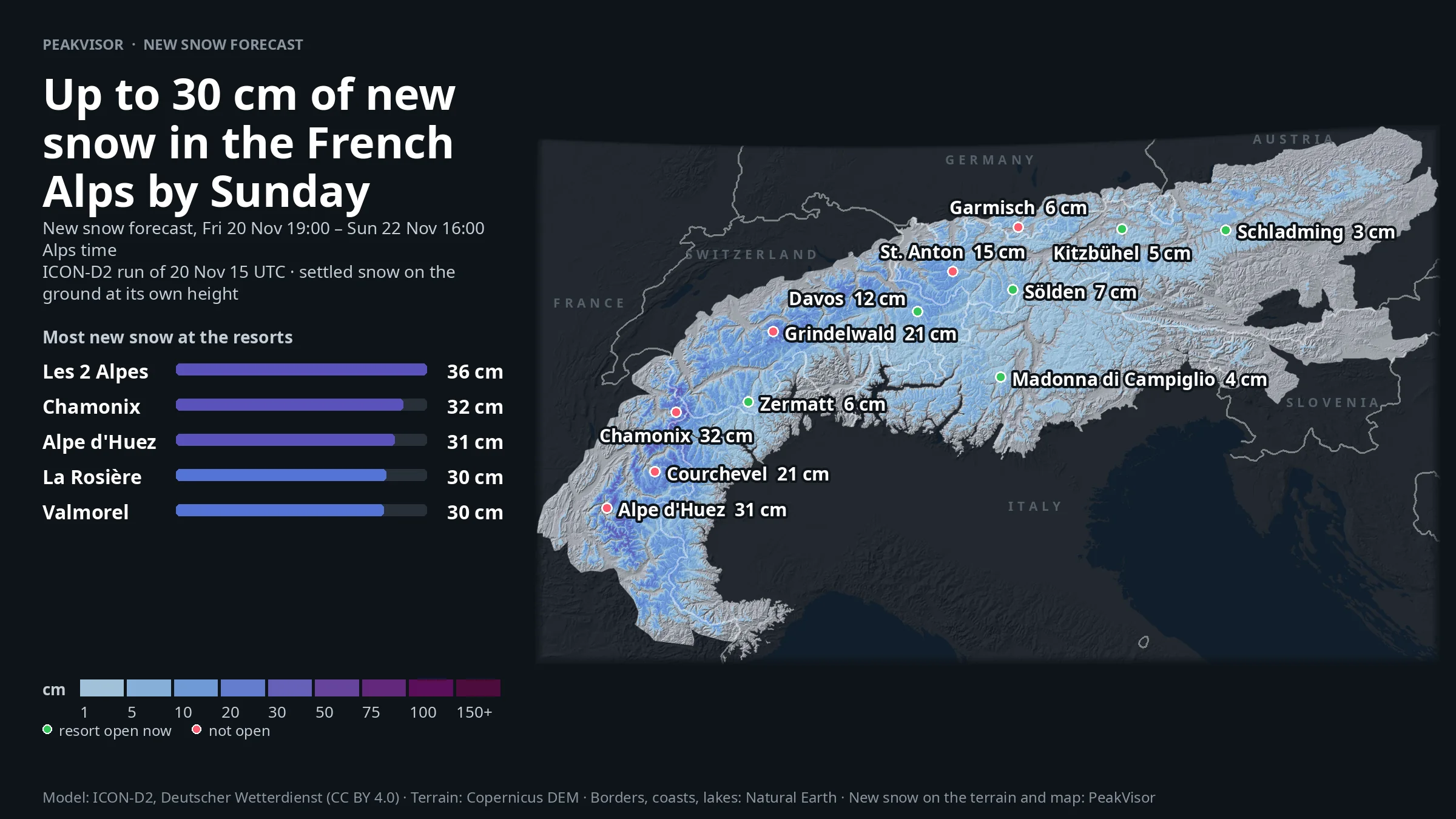
Good evening! Here is the outlook for tomorrow, Saturday 21 November: the storm is still busy in the western Alps, with fresh snow from Mont-Blanc to Veny Valley and another top-up due by Sunday. The central Alps join in next, while the eastern Alps get smaller amounts and a lively ridge wind.
Our Thursday evening forecast came in mostly as forecast: we expected 38 cm in Veny Valley and 28 cm came, and 35 cm in Emosson with 26 cm now shown. The miss was Vanoise, lower at 15 cm instead of 26 cm. In the last 24 hours, Mont-Blanc led with 29 cm; over 3 days, Mont-Blanc and Veny Valley both reached 72 cm, with Génépi on 64 cm. Ligurian Alps and Lower Austria stayed dry. According to Météo-France, Mont-Blanc saw 30-40 cm at 1800 m on Friday, with 100 cm on north slopes at 2500 m.
Tonight into tomorrow, Schreckhorn is the sharpest 24-hour pulse with 24 cm, while the 2-day totals still favour Veny Valley with 34 cm, Emosson with 33 cm, and Mont-Blanc and Beaufortain around 30 cm. Snow falls to around 1600 m in Emosson, 1900 m in Mont-Blanc, and 2240 m in Veny Valley; Ligurian Alps stays dry. The SLF expects up to 29 cm at 2500 m in Glarus, with a snowfall limit near 1120-1320 m. Further ahead, ECMWF’s ensemble makes 20 cm or more all but certain in Grandes-Rousses, Génépi and Veny Valley by Friday 4 December; Southern Julian Alps is likely too, while Vallarsa has a fair chance.
A small but tasty early-season menu: 32 resorts are in season, and 18 have lifts running by live status. Val Thorens has 51 cm from the last 3 days and about 74 cm of snow on its slopes; Tignes has 55 cm fresh over 3 days and about 58 cm. Zermatt offers the deepest open pick with about 88 cm and 7 of 38 lifts running. Les Diablerets has 2 of 45 lifts running, but note high avalanche danger. Next up: Les 2 Alpes, La Thuile and Courmayeur open Saturday 28 November.
For Saturday 21 November the highest official rating is high, level 4 of 5, in parts of Lower Valais, plus Mont-Blanc, Bex-Villars and Wildhorn. Considerable, level 3, is widespread across 102 rated regions. The SLF warns of new snow on north- to south-east-, west- and north-west-facing slopes above 2200 m in the level-4 Swiss areas. The Aosta Valley service flags new snow on all aspects above 2100 m and wind slabs above the tree line. Ridge winds reach about 100 km/h in Upper Austria and Styria, drifting fresh snow. No rating yet from Austria, Germany or Slovenia, and most of Italy; read the local bulletin before leaving groomed runs.
Enjoy the fresh turns, keep your margins wide, and see you in the next update.
Snow depth is modeled on ski slopes. Check the resort’s own snow report for measurements. Report text, maps and lift information carry their own publication and update times.
Follow the fresh snow or look at what’s coming next.
0 of 0 regions
Season dates are a starting point. Check the resort’s latest opening and lift information.
| Resort | Last 3 days | Next 48 h | Snow depth (model) | Lifts reported | Season / status |
|---|
0 of 0 resorts · Calendar status as of Nov 20. Modeled depth describes upper slopes, not reported base depth. Lift reports have their own update times.
Take a closer look with PeakVisor. Explore terrain in 3D, find ski routes and keep your mountain maps with you offline.
Import a ski touring GPX into your PeakVisor profile to see the route in 3D. Public routes can also be shared as interactive 3D widgets.
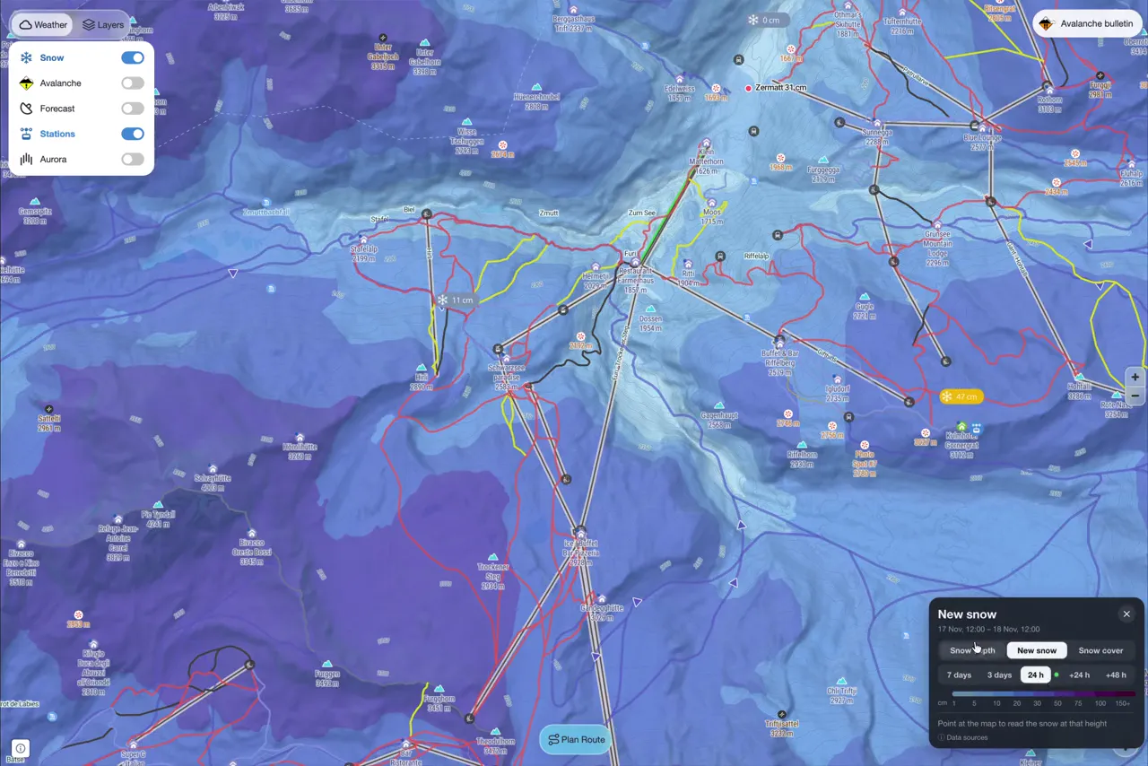
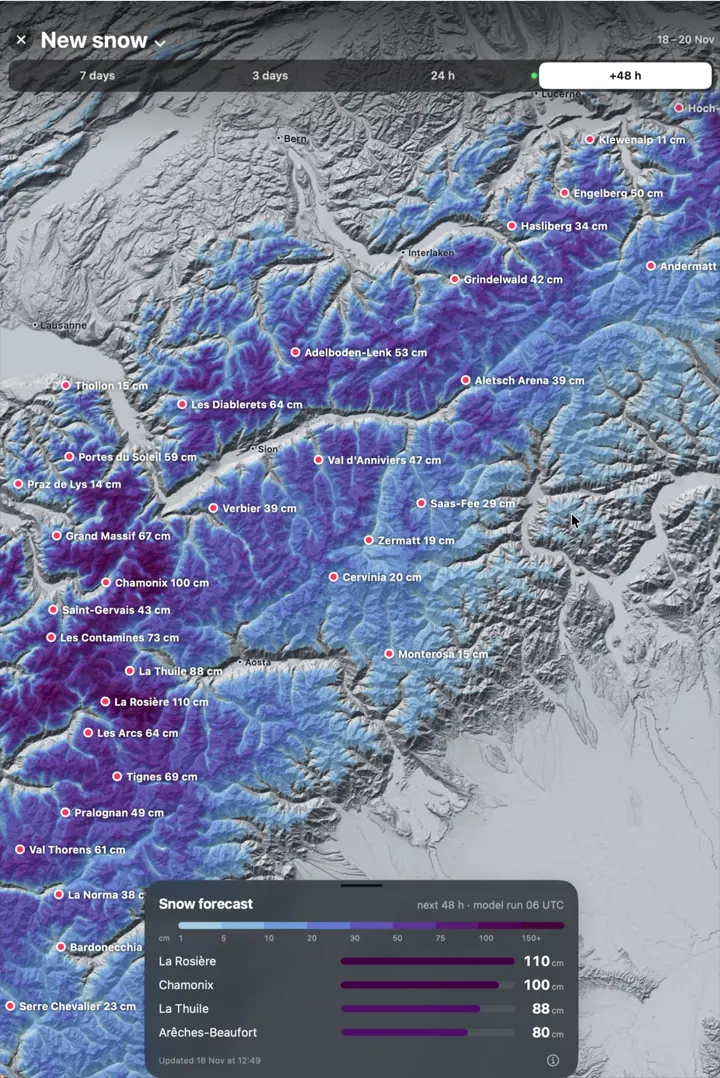
Weather models estimate snowfall, and station measurements help estimate snow depth. Sentinel-2 satellite imagery, webcams and stations help us map where snow covers the ground. Official ski resort reports add local snow readings and lift status where available.
Thousands of people use PeakVisor to navigate in the mountains and share feedback. We’ve spent years refining the app in the field with mountain guides and avalanche experts.
On the same mountain, snow can reach much lower on a shaded slope than on a sunny one. PeakVisor estimates the snow-cover line by aspect, so you can compare what the approach might look like on slopes facing different directions.
See fresh snow, snow cover and ridge wind alongside official avalanche information for the same region. Follow the link to the full local bulletin to check its validity, danger rating and avalanche problems.
Original snow data for the report dated November 20. Set 202611201858. Data times are shown in your local time zone.
Snow maps: PeakVisor (snowsense) New snow and snow depth: ICON-D2, Deutscher Wetterdienst (open data, CC BY 4.0), modified; before 9 Nov 2026 ECMWF IFS open data (CC BY 4.0), modified; scaled to the weather stations Snow cover: contains modified Copernicus Sentinel-2 data 2026; webcams of Panomax GmbH, feratel media technologies AG (www.feratel.com) and foto-webcam.eu and the cameras official resort and tourist-office pages embed; weather and avalanche service stations Avalanche danger: the EAWS member services, via avalanche.report 0 °C level and wind: ICON-D2, Deutscher Wetterdienst (open data, CC BY 4.0) Micro-regions: EAWS (regions.avalanches.org)
The daily Alps report shows where snow fell, what’s forecast, and how low snow cover reaches on slopes facing different directions. Compare regions at the same elevation, check the official avalanche outlook, and explore the terrain on PeakVisor’s 3D ski touring map.
In the November 18, 2026 edition, the estimated snow-cover line in Mont-Blanc was about 1,800 m on north-facing slopes and 2,090 m on southwest-facing slopes. That’s nearly 300 m of difference in one region. The line estimates the elevation where about half the open ground on slopes facing that direction is snow-covered.
The snow report shows where snow lies and how much fell. Avalanches depend on how the snowpack has formed and changed. Use the full official avalanche bulletin for the danger rating and the avalanche problems, including affected slope directions and elevations where reported. Check its validity for the area and day of your tour.
Snowfall totals are weather-model estimates adjusted to station data. Regional snowfall uses the 90th percentile over open ground, and resort snowfall uses the 90th percentile over its slopes. Regional depth ranges span the 10th to 95th percentiles of snow-covered ground, and the depth map shows the regional maximum. The resort’s official report is the source for a local base measurement when available.
PeakVisor publishes a daily briefing. The live page checks for updates while it’s open and shows when the underlying data was produced. If a refresh fails, the last available data stays visible with its original timestamp.
Yes. Each dated edition preserves its original source data and forecast window. Choose the latest report for current conditions.