Scan the QR code and open PeakVisor on your phone
Situated in an area with many caves and spectacular scenery, the Wuyi Mountains have long been associated with cults of Daoism, a philosophy that has influenced all aspects of Chinese culture for more than 2,000 years. Ziyang Shuyuan, a well-known academy established in 1183 by the famous Neo-Confucian philosopher Zhu Xi (1130–1200), flourished there in the 18th and 19th centuries; its ruins have been partially rebuilt. Heavily forested and sparsely populated, the Wuyi Mountains are famous for their timber and bamboo and have long been renowned for their fine tea. Many oolong and black teas are produced in the Wuyi Mountains, including Da Hong Pao (Big Red Robe) and lapsang souchong.
Geographically, the Wuyi Mountains (Chinese: 武夷山) are a mountain range on the border between Fujian and Jiangxi provinces, southeastern China. Having been originally used in reference to a cluster of peaks in northwestern Fujian, the name is now applied generally to the range along the southwest-northeast axis, starting from Xianxia Ling in the north, ending with Jiulian Mountain in the south and forming the northern and central parts of the Fujian-Jiangxi border. The highest peak and the main peak in the area is Mount Huanggang (2,158 m) on the border of Fujian and Jiangxi, making it the highest point of both provinces.
Due to their great size, the Wuyi Mountains area has some of the most beautiful and diverse natural scenery in China, and the region is a popular tourist attraction. A protected area of about 100 square km was designated a UNESCO World Heritage Site for cultural, scenic, and biodiversity values in 1999.
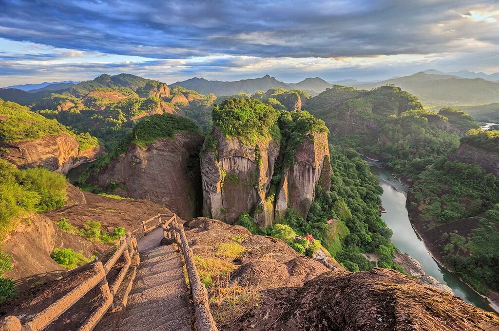
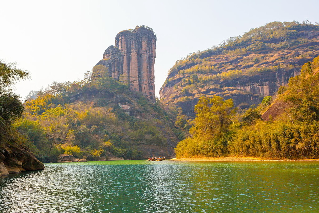
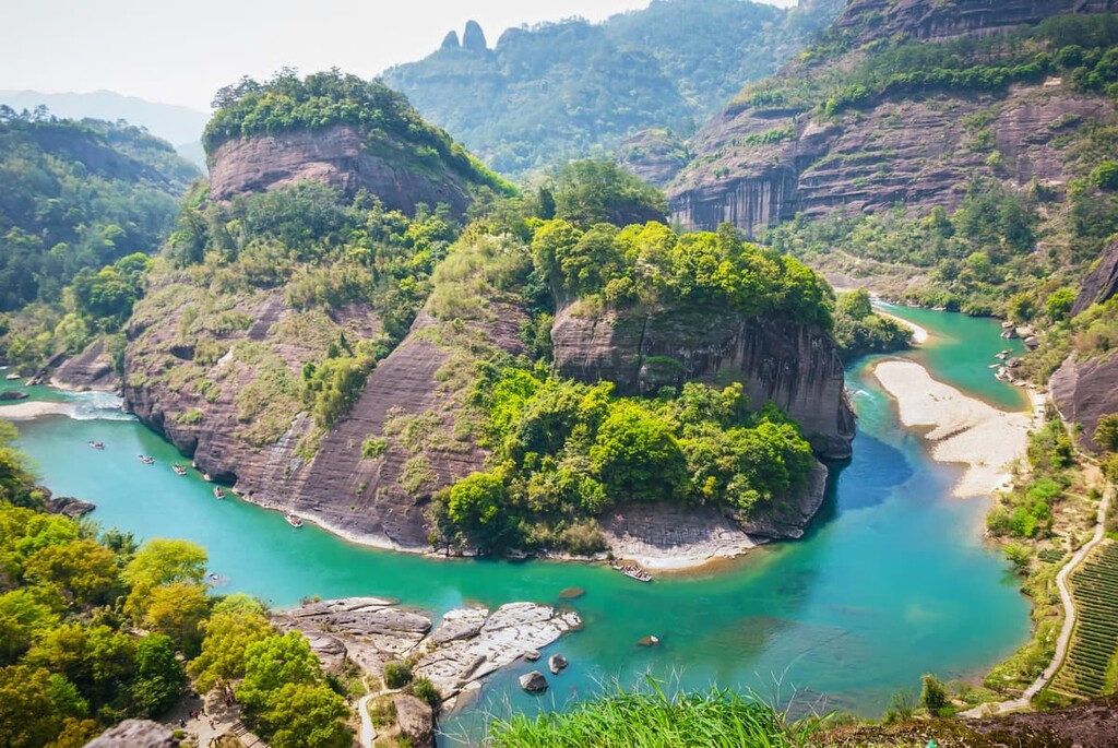
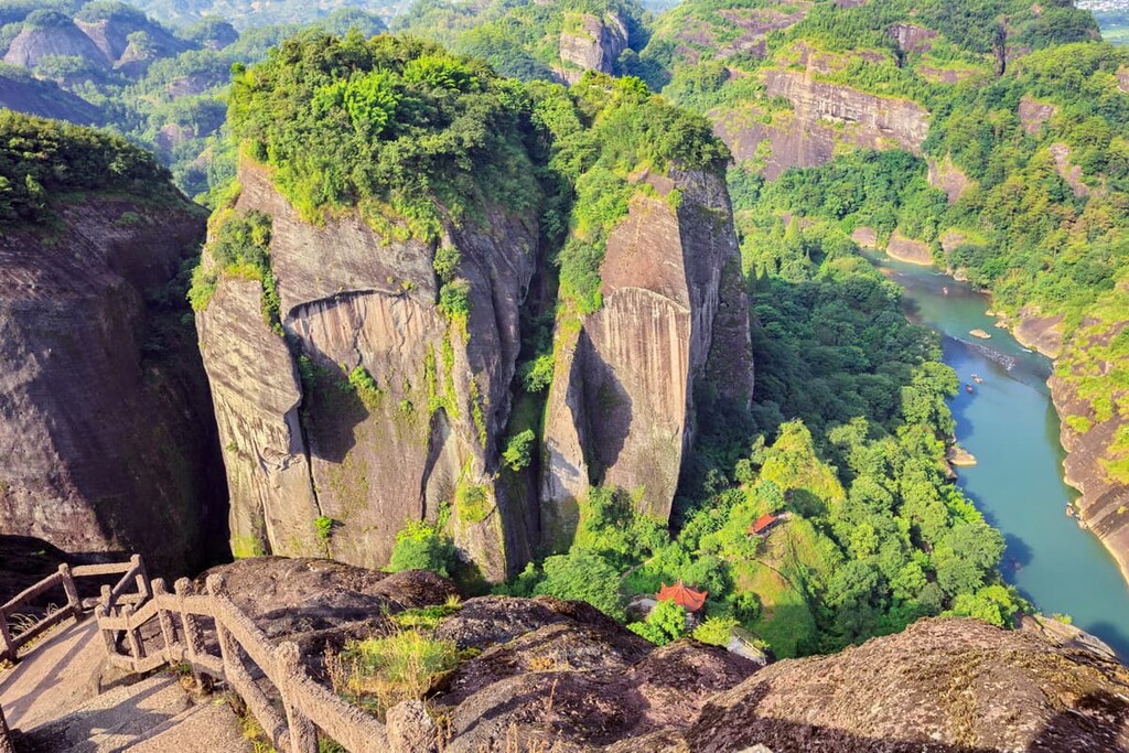
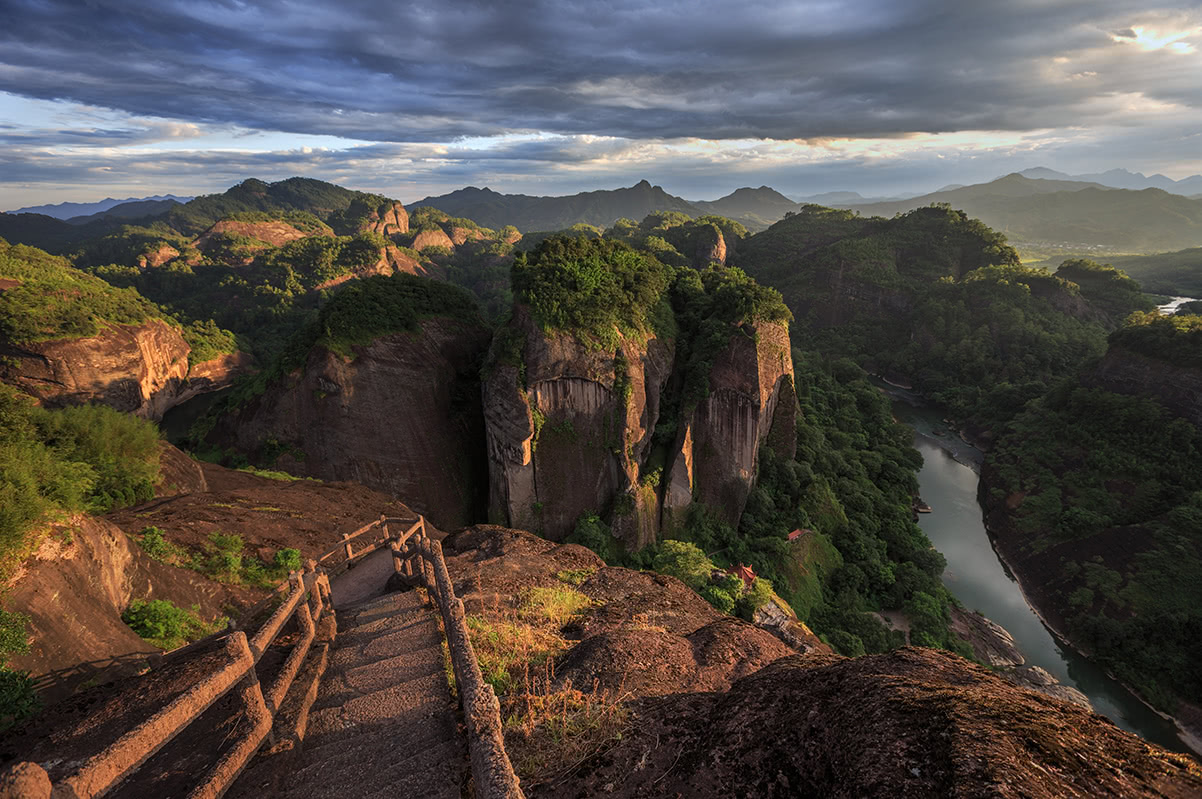
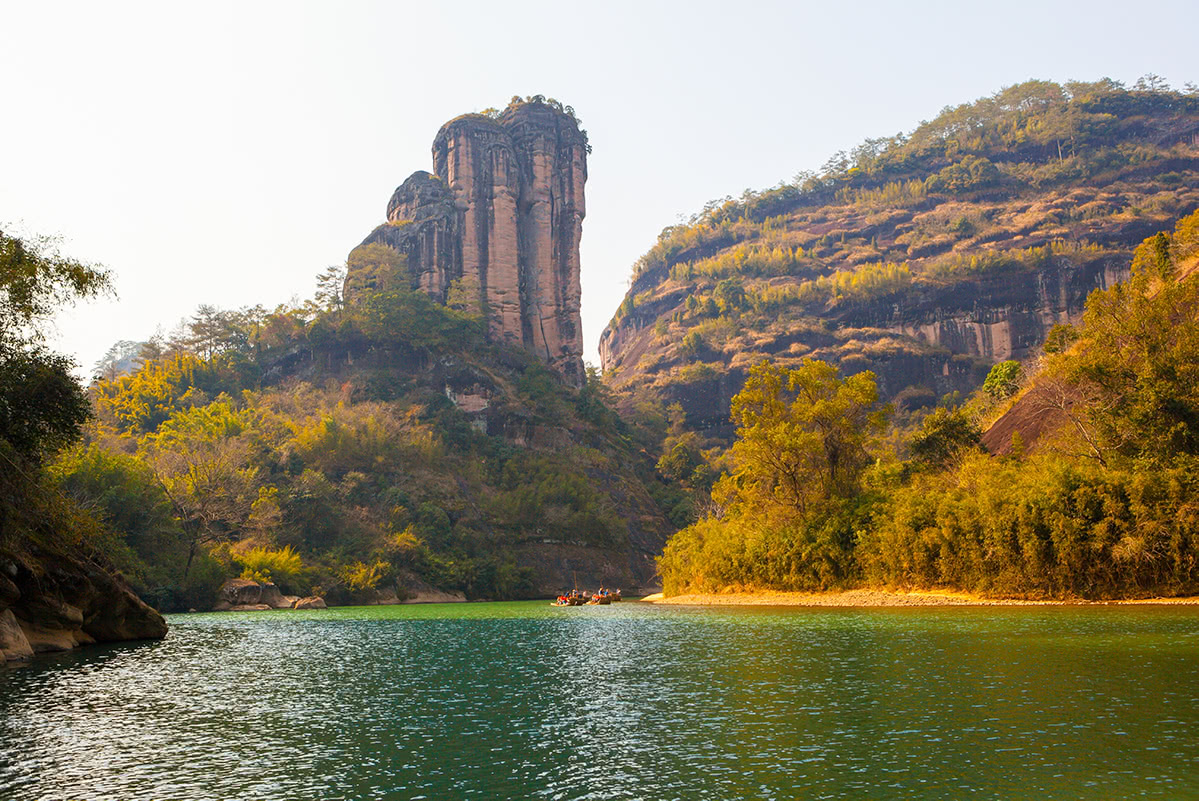
Mount Wuyi (Wu Yi Shan), located in northwest Fujian Province, is a very popular national AAAAA scenic area. The mountain is richly endowed with wonderful, elegant and ancient scenic spots, including Nine Bend Stream (Jiuquxi), Heavenly Tour Peak (Tianyoufeng), Water Curtain Cave (Shuiliandong), Tiger Roaring Rock (Huxiaoyan), A Thread of Sky (Yixiantian), Wuyi Palace, the site of Ziyang Shuyuan and cliff carvings from all the dynasties through history. There are many trails you can choose from to savour the beauty of the area. Of all these, Nine Bend Stream is reputed as the soul of the Wuyi Mountain, winding for 60km including 9.5km through the scenic area. Along both banks is typical Danxia landform. The prettiest part is within the rafting to the north gate.
How to get to Mount Wuyi: Mount Wuyi is located south of Wuyishan City and northwest of Fujian Province, and borders on Jiangxi Province. To get there, you need to reach Wuyishan City first. You can do so
(1) By Air: You can fly to Wuyishan Airport, the closest airport to the scenic spot. From the airport, bus No. 6, 7, or 9 can take you to the attraction directly.
(2) By Train: There are three railway stations in Wuyishan City, mainly operating the trains to/from Shenzhen, Beijing, Shanghai, Xiamen, etc. Buses are available from all three stations to Wu Yi Shan.
Ticket price: The entry ticket of Wu Yi Shan is CNY 140 between March and November and CNY 120 between December and next February. The fares of sightseeing bus, bamboo rafting and the Impression Da Hong Pao show are not included. Since The Impression Da Hong Pao show is very popular, it is recommended to book the ticket at least 1-2 days in advance.
Open time:
April - November: 6:30am - 6:00pm
December - March: 7:00am - 5:00pm
Stay safe: Do not hike outside the paths as the area has some dangerous cliffs and many snakes, though some rather large ones are rare. Camping is not allowed in the park. The area is otherwise very safe. People are friendly. The staff of the park are helpful and the emergency staff are available in case of accidents.
Wufu Gang, at the junction of Shangrao County in Jiangxi and Wuyishan City in Fujian, is the sixth highest peak in Jiangxi. Starting from a small village at the foot of the mountain, you will enjoy vast, quiet primaeval forest, abundant waterfalls and streams, rocks of strange shapes and positionings, as well as beautiful sunrises and sunsets all the way hiking to the summit.
Note: The appropriate seasons to visit the place are spring, autumn, and winter. It may take 3 to 6 hours hiking one way. You can camp on the ridge.
Dawang Shan is surrounded by some beautiful small villages and covered by dense vegetation. Starting from Jinzhu village, it will take around 2 hours to get to the top of Dawang Shan and you will see the ancient paths that remain intact along the way. The hiking trail is not part of the Mount Wuyi scenic area and is in a rather remote location. Some parts of the mountain paths are steep. Get well prepared before you start to conquer Dawang Shan.
Huangmaojian Peak is the highest peak of Zhejiang Province. The most popular and recommended trails to conquer Huangmaojian often include the second highest peak of Zhejiang, Mount Baishanzu, too. Both mountains shape the ridge of Zhejiang. The trails, well packed with mind-blowing scenery, are not very hard but require stamina. It’s advised to join a team of experienced hikers and make a plan of a hiking trail in advance.
Recommended trails:
The whole journey will take more than one day.
Day 0: Arrive in Qingyuan County, Lishui City, Zhejiang. You can take a flight to Wenzhou Airport, take a bus to Lishui East Station, and then transfer to the bus to Qingyuan. Remember to check the schedule to ensure that you don’t miss the last bus.
Day 1: Take a car from Qingyuan to the gate of Baishanzu scenic area. Baishanzu (1857 m) – Chamuyu Tree Farm – Liyang Village (or Longyan Village) – Maliandai Village.
Day 2: Maliandai Village – Fengyang Lake – Huangmaojian South Peak (1917 m) – Huangmaojian (1930m) – the gate of Huangmaojian scenic area. You can take a bus to Longquan County after you leave the scenic area.
The advantages of this trail include that:
(1) you can have a homestay in the village overnight;
(2) there is no need to camp so you can travel light;
(3) staying in Maliandai Village, but not Liyang or Longyan ensures that you have enough hiking (>30km) for Day 1.
There is a well-known trail called Qian Ba Chuan Yue (千八穿越). It’s a typical trail that covers 80% of the 1,800-meter mountains in Zhejiang, which are Fengyang Shan North Peak, Fengyang Shan, Huangmaojian, Huangmaojian South Peak, Huangfengyangjian, Shaoxiang Rock, Tiantang Shan, Datiantang, Baishanzu, Niulujian (also known as Xinlanjian) and Huangcunjian. This trail is very hard, long and complicated, and it is thus called “The No. 1 Torture of Eastern China” by the outdoor enthusiasts. The whole trail is 27-kilometre long and takes 3 or 4 days. A professional local guide is the basic guarantee of a safe hike.
Dushujian, Guo Feng Ao and Xianglu Shan (香炉峰) together make up a trail named “The K2 of Eastern China (华东K2)”, one of the most strenuous trails of Eastern China. K2 originally refers to Chinese Qogir Feng (or Chogori), the highest point of the Karakoram range and the world's second highest peak, second only to Mount Everest. K2 is known as the Savage Mountain due to the extreme difficulty of ascent, which is even much more difficult than Mount Everest. The K2 of Eastern China trail is actually quite a recent discovery. Compared with Qian Ba Chuan Yue, K2 is more interesting, yet more difficult due to the lack of water supply. The trail, on the ridge of Wuyi Mountains along the border between Jiangxi and Fujian, starts in Xiao Jia Yuan, Qianshan County, Shangrao, Jiangxi and ends in Gankeng Tree Farm in Nanping, Fujian. Named after K2, this trail is extremely hard due to the lack of water supply, dense forests and few visitors. To explore the trail safely, you will need to join a group of experienced hikers with a local guide.
Gu Shan Jue Ding Feng is a very popular relaxing attraction in Fuzhou and therefore is one of the most visited places by both the locals and the travellers. All the trails to the top are well developed and provide enough options for different kinds of needs. There are trails for hikers who enjoy walking with crowds of people, as well as for hikers who love hiking alone. There are also cable cars and minivans to get the visitors to the summit without extra effort. Having some tea while looking at the whole Fuzhou City at the top is a favourite pastime of the locals.
Qi Shan is where Fuzhou Qishan National Forest Park is located, lying to the west of Fuzhou City, only 20 minutes’ drive from the city. Covering an area of 3,587 hectares, the mountain boasts fresh air, wild plants, animals, especially monkeys, ancient roads, temples, waterfalls, lakes, deep ponds, bridges, and caves. It also features granite landscapes. It is a perfect place for summer vacations, exploration, camping, picnics and hiking. The admission price is 20 RMB for a person. At the foot of Qi Shan there are 52 hot springs and based on them there is a good hot spring resort hotel, where you can have a good rest after some good hiking.
Jin Nao Shan is an AAAA scenic area in Taining County and Jianning County in Fujian, providing the Fujian’s highest and longest cableway, the highest time tunnel and the highest plank road, as well as mountain railway narrow-gauge train and outdoor ski area.
The admission is 180 RMB per person, including the fares of a round-trip cable car and a shuttle bus in the area. The mountain train and ski area cost extra. The open time is 8 a.m. to 2 p.m. (1:30 p.m. in winter).