Scan the QR code and open PeakVisor on your phone
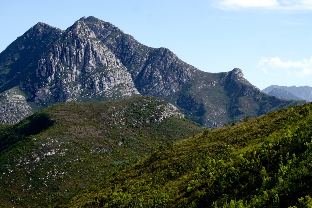
The Outeniqua Mountains constitute a significant portion of the renowned Garden Route National Park along the southern coast of South Africa. There are 460 named peaks in the Outeniqua Mountains. Nadouwsberg is the highest point at 2,421 meters (7,943 ft), while the most prominent mountain is Cockscomb, measuring 1,768 meters (5,801 ft).
The Outeniqua Mountains span approximately 1,000 km (621 mi) along the Western Cape province. The range extends from Mossel Bay in the west and across George and Knysna to the Keurbooms River valley in the east. It forms a continuous barrier between the coastal lowlands and the Little Karoo plateau, connecting to the Langeberg range in the west and the Tsitsikamma mountains in the east.
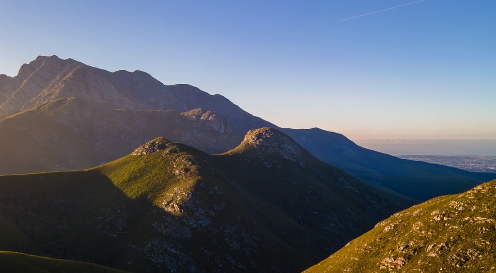
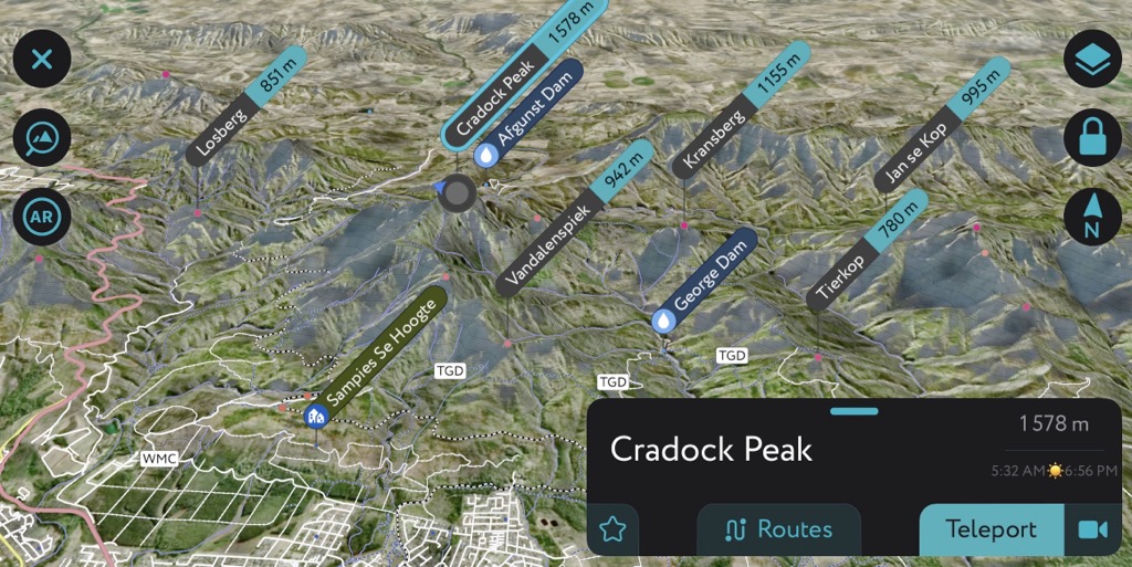
The highest peak in the Outeniqua Mountains is Cradock Peak, which reaches 1,570 m (5,150 feet). These mountains are characterized by their relatively modest elevations compared to other mountain ranges in South Africa. However, they are still quite rugged and feature significant elevation prominence from the valleys.
Due to the area's ecological significance, parts of the Outeniqua Mountains, including its indigenous forests and fynbos, have been designated protected areas or reserves. These areas include the Garden Route National Park, Outeniqua Nature Reserve, George Peak Nature Reserve, Saasveld Forest Reserve, and Witfontein Nature Reserve.
The Outeniqua Mountains attract tourists and nature enthusiasts with its scenic beauty, diverse flora and fauna, and history. The N2 highway crosses the mountains, which connects cities along the Garden Route, such as George and Knysna, making it accessible to visitors.
Additionally, several roads and passes, including the Outeniqua Pass, Montagu Pass, and Seven Passes Road, traverse the range, offering views and access.
The Outeniqua Mountains are part of the Cape Fold Belt, a mountain range formed 230 to 289 million years ago by the collision of Gondwana and Laurasia. The range is comprised mainly of resilient dolomite and quartzitic sandstone; these rocks were deposited in a shallow sea 500 million years ago and later uplifted by tectonic forces.
Soft layers of shale, mudstone, and conglomerate interspersed in the mountains contribute to varied soil types and vegetation patterns. The Outeniqua Mountains' geological history involves faulting, folding, uplift, erosion, glaciation, and volcanism, evident in features like the Outeniqua Fault, Montagu Pass, and Cradock Peak.
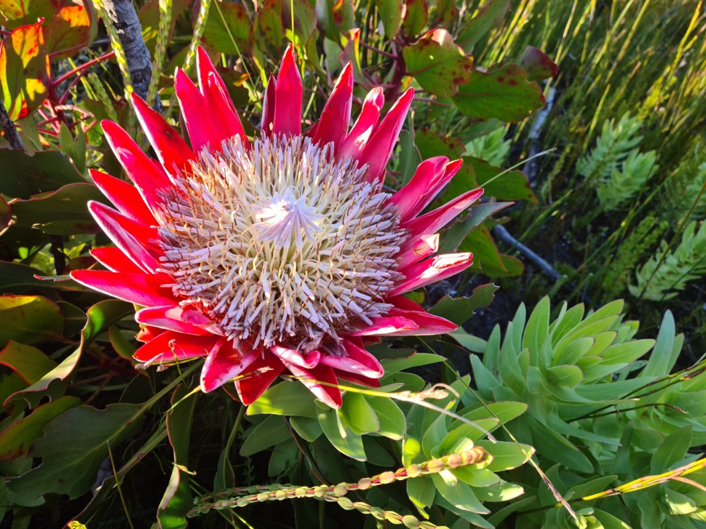
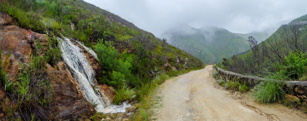
Proximity to the ocean influences the climate in the Outeniqua Mountains. The region experiences a Mediterranean climate with mild, wet winters and warm, dry summers. The range's climatic and ecological variations on the north and south sides contribute to its unique biodiversity. The southern mountains face the Indian Ocean and experience higher rainfall and humidity, creating a moist and temperate environment. Montane fynbos - shrubland rich in endemic plant species and flowers - and afromontane forests dominate this side.
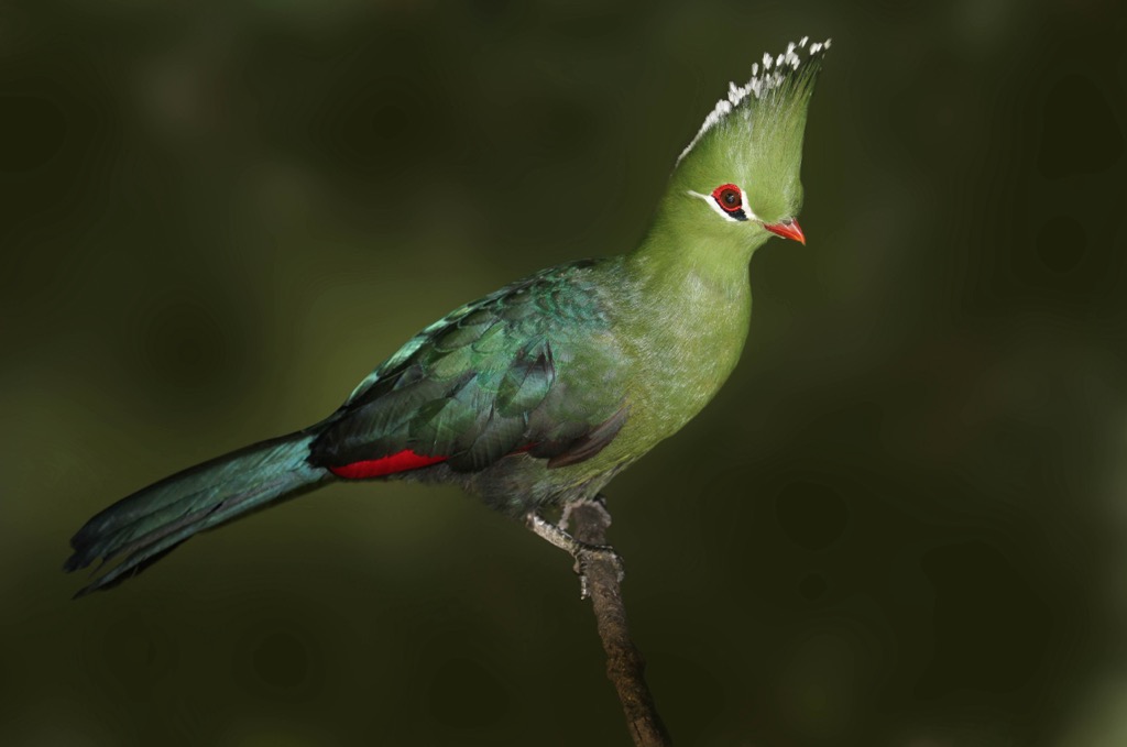
Mesic south-facing slopes harbor Afromontane forest patches of Outeniqua yellowwood and ironwood. The mountains are remote enough to have avoided the complete destruction of their native game animals, like many other parts of Africa. The forest still shelters mammals like leopards, klipspringers, and a range of bird species, including the endemic Knysna turaco and raptors like the black eagle and jackal buzzard. Although less common, there are still spottings of the Knysna elephant in the southern hills.
The fynbos is a distinctive South African vegetation type well-represented in the Outeniqua Mountains' Mediterranean regions. Fynbos is known for its extraordinary biodiversity of endemic plant species, including proteas, ericas, and restios. These plants have adapted to the region's Mediterranean climate with its wet winters and dry summers.
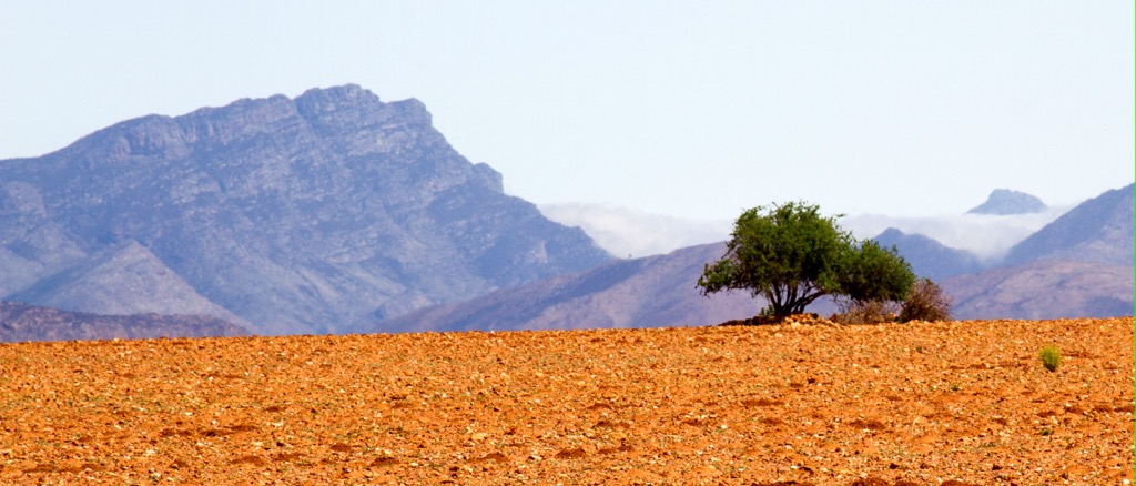
In contrast, the north side of the Outeniqua range, sloping down to the semi-arid Little Karoo, exhibits drier and warmer conditions. The arid northern sections’ karroid shrubland is dominated by resilient shrubs adapted to drought and heat, while the renosterveld shrubland features grasses, herbs, and geophytes. Plants on the north side typically feature smaller leaves, thicker stems, and, in some cases, succulent adaptations for water storage.
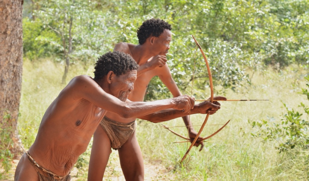
The human history of the Outeniqua mountains begins with the indigenous peoples who have lived there for millions of years. Most of the history of humanity consists of the stories of prehistoric bushmen who evolved on this continent. However, the most recent indigenous peoples are the San and Khoikhoi, whose roots stretch back millennia, long before recorded history.
The San people arrived in this area an estimated 200,000 years ago, while the Khoikhoi arrived around 1,500 to 2,000 B.C. Upon the arrival of European settlers, conflict and smallpox devastated the San and Khoikhoi communities.
Bantu-speaking peoples, who migrated to southern Africa from other parts of the continent, also inhabited the area from about 0 CE onwards. These groups practiced agriculture, introducing maize and livestock. Being a subsistence culture, rather than hunter-gatherers, likely relegated them to the fertile valleys over the rocky slopes of the Outeniquas.
European exploration of the area began in the 1500s when Portuguese explorers established trade relationships with the local inhabitants, particularly for cattle and other commodities. Despite this early contact, the Portuguese didn’t settle in the region.
Dutch settlers in the late 1600s established farms and towns, sparking conflicts with the indigenous Khoikhoi and San. The 1700s and 1800s witnessed the escalation of clashes, resulting in the displacement of the Khoikhoi and resistance from the San people.
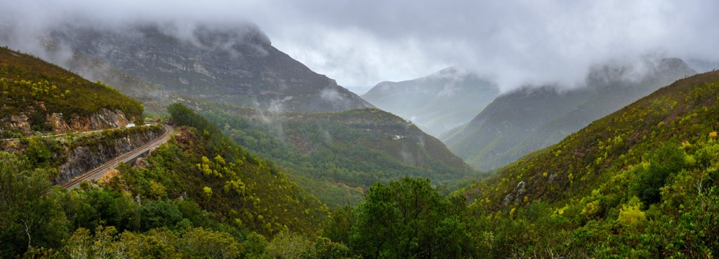
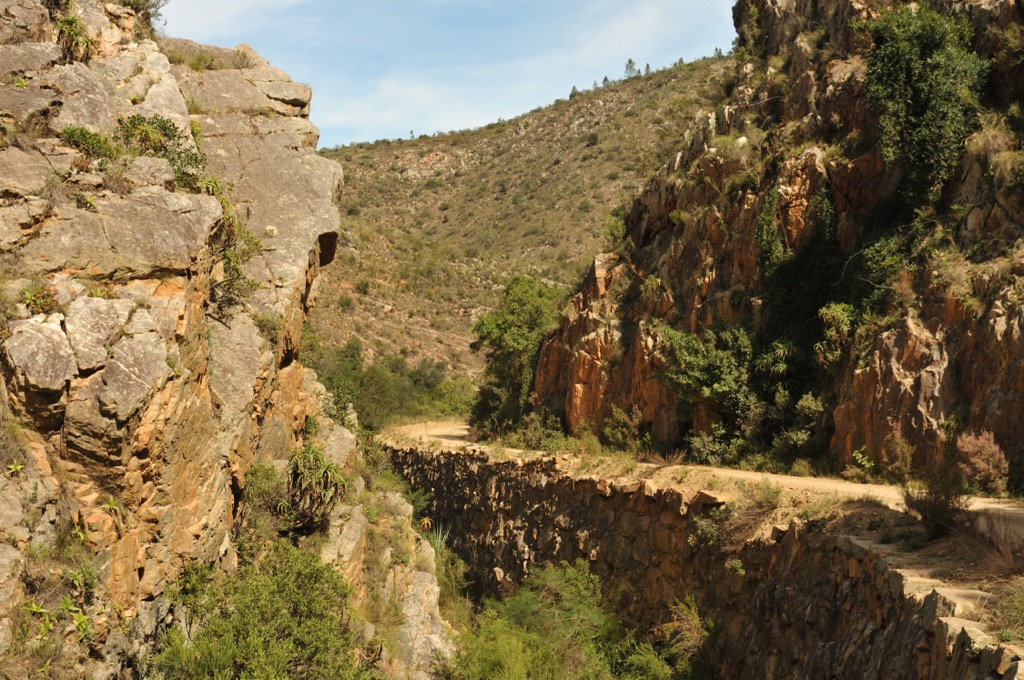
At the turn of the century in the early 1800s, a new wave of settlers from Britain brought innovative ideas and technologies to the region. They constructed roads and railways through the mountains, exemplified by the Montagu Pass and the steam railway known as the Outeniqua Choo-Tjoe.
In the 20th century, there was growing recognition of the ecological significance of the Outeniqua Mountains and the need to conserve the natural environment. Protected areas now include the Garden Route National Park, Outeniqua Nature Reserve, George Peak Nature Reserve, Saasveld Forest Reserve, and Witfontein Nature Reserve.
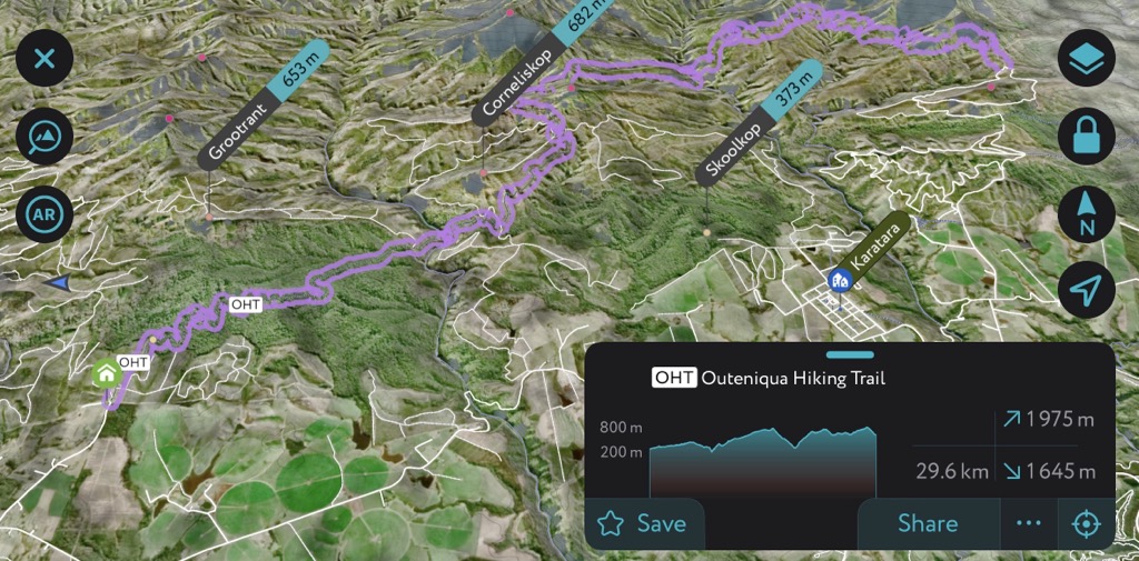
The Outeniqua Hiking Trail extends 108 km (67 mi) from Beervlei Hut near George to Harkerville Hut near Knysna. As one of the country's longest and most famous hikes, the trail showcases its diverse landscapes of forests, rivers, peaks, and valleys.
Throughout the seven-day trek, hikers enjoy the sights and sounds of the indigenous forest, home to many birds and animals, including elusive elephants. The trail also crosses several rivers and streams, some offering refreshing swimming holes. This trail is well-marked and maintained, with comfortable huts at each overnight stop.
Notable segments include the historical Millwood area with remnants of gold mining, the Knysna River crossings via a suspension bridge, and the steep Rondebossie section with panoramic views of Jonkersberg, Platboshoogte, and Keurkop. Hikers can also look forward to the trail’s changing scenery as they enter the Diepwalle Forest, home to a 600-year-old yellowwood, King Edward VII Big Tree.
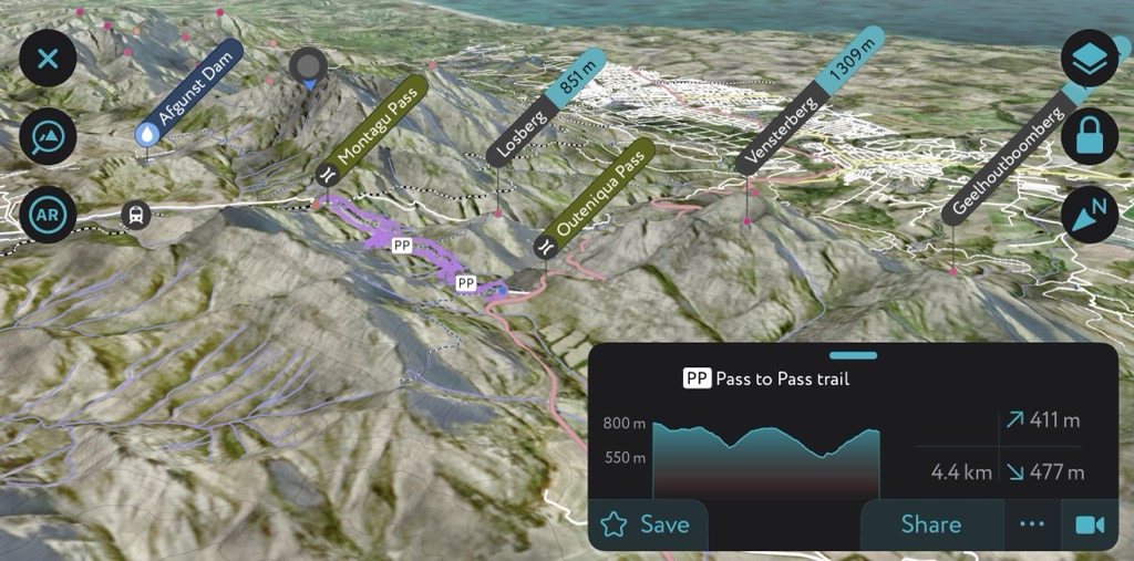
The Pass to Pass Hiking Trail is a trekking route that connects Montagu Pass and Outeniqua Pass in the Outeniqua Mountains. This trail spans 7.5 km (4.6 mi) and traverses the diverse landscapes with a climb to the summit of Losberg.
Montagu Pass is the trail’s starting point, a historical route established in 1847 by the British that showcases panoramas of the mountains, valleys, and archaic stone bridges. Along the trail, hikers trace Outeniqua Choo-Tjoe’s former railway line utilized for timber transportation from the forests to the coast.
The trail crosses two rivers, the Keur River and the Touw River, which have clear water and inviting pools for swimming. Hikers also roam patches of indigenous forest, where they can observe various bird species and wildlife, such as monkeys, baboons, and bushbuck.
The trail ends at the Outeniqua Pass, a modern pass built in 1951 to provide an alternative to the narrow and steep Montagu Pass. The Outeniqua Pass is the primary route for traffic between George and Oudtshoorn. It provides vistas of the mountains, coastal plateau, and noteworthy historical landmarks such as the old toll house and the memorial plaque commemorating Queen Victoria’s Diamond Jubilee.
The Vensterberg Hiking Trail is a challenging ascent to the summit of Vensterberg, one of the Outeniqua Mountains’s most prominent peaks. The trail's highlight is the rock formation near the summit, creating a window through which hikers can see a part of George. Indeed, it’s the trail’s namesake, as Vensterberg means ‘window mountain’ in Afrikaans.
The trail starts from Sputnik, a radio tower at the top of Outeniqua Pass, and follows a clear path to the summit of Vensterberg. It’s about 4.5 km (3 mi) long and features an elevation gain of about 480 meters (1,575 ft). Given its unmarked nature, hikers are advised to rely on GPS devices or smartphones for navigation (like the PeakVisor mobile app). The trail has some steep and rocky sections that require scrambling, so appropriate footwear and cautious foot placement are imperative for a safe hike.
The summit offers sweeping outlooks of the Outeniqua Mountains, including Losberg, Tolberg, Geelhoutboomberg, and Cradock Peak.
The Losberg Hiking Trail, an integral segment of the Pass to Pass Hiking Trail, spans 7.5 km (4 mi) and has an elevation gain of around 530 meters (1,739 ft). Translated as ‘lost mountain’ in Afrikaans, Losberg is often shrouded in mists or clouds.
Much like Vensterberg Hiking Trail, the route starts at Sputnik and follows a clear path along the ridge to the summit. During the climb, hikers encounter patches of fynbos, an indigenous South African vegetation. Once on the mountaintop, Vensterberg, Cradock Peak, and Tolberg are within clear sight.
The Cradock Peak Hiking Trail presents an arduous journey with a mileage of 18 km (11 mi). Hikers start and end the trail at the Witfontein Forestry Station, so hikers must first obtain a mandatory free permit before commencing the route.
Throughout this trek, panoramic views of pine plantations, Outeniqua Choo-Tjoe’s railway line, and the peaks of Skurwekop, George Peak, Losberg, Tolberg, and Vensterberg remain prominent. The trail’s difficulty intensifies with rocky scrambles requiring caution, stamina, and experience.
The George 6 Peaks entails conquering six peaks of the Outeniqua Mountains. It is widely known as the George Six Peaks FKT (Fastest Known Time) Challenge, where hikers attempt to climb these six peaks in a single day to find the fastest finisher. The total distance covered is approximately 45 km (28 mi), with a total elevation gain of about 3000 meters (9,843 ft).
The George Six Peaks Hiking Trail encompasses the following peaks: Vensterberg, Losberg, Cradock Peak, George Peak, Tierkop, and Groenkop. Prominent points of this trail are George Peak’s outlooks onto the coast and inland Klein Karoo, Tierkop’s lion-head-shaped peak, and the fields of farmlands and forests seen from the top of Groenkop.
The Rooiberg Hiking Trail winds through the uneven and rocky terrain of the northern Outeniqua Mountains, stretching approximately 18 km (11 mi). The trail commences at the Rooiberg Hut and is accessible via a gravel road from Van Wyksdorp, taking hikers a day or two to complete, depending on their fitness levels.
This circular route meanders through varied landscapes, including fynbos, grasslands, forests, and rocky slopes. Highlights of the trail include views of the Klein Karoo and the Gamka River Valley from Rooiberg Pass, Rooiberg Cave's ancient rock paintings, and Rooiberg's summit. This vantage point offers vistas of Bakenskop, Witberg, the western Langeberg, and the Swartberg mountains in the north.
The Groenewiede Trail offers three different routes, the 9 km (5.5 mi), 11 km (7 mi), and 13 km (8 mi), that vary in length and difficulty. The trail starts and ends at the Saasveld Forestry Research Station near George.
The trail crosses the Kaaimans River, where hikers stop and swim in a natural pool. The trail then leads through the indigenous Groenewiede Forest, home to towering Outeniqua yellowwood and ironwood trees.
Hikers can spot the endemic Knysna turaco, Narina trogon, bushbuck, and baboons. The trail also passes through fynbos, where hikers can admire the variety of flowers, especially in spring and summer.
George is a city renowned for its picturesque landscapes and diverse outdoor activities. Situated at the foot of the Outeniqua Mountains and along the lush Garden Route, George has earned a reputation as a hub for nature enthusiasts.
For the adventurous, George boasts an array of outdoor activities. Kayakers, fishermen, and boaters can take advantage of the numerous lakes and rivers. There is surfing along the coastline and whale watching during the migration season. World-class golf courses await golf enthusiasts.
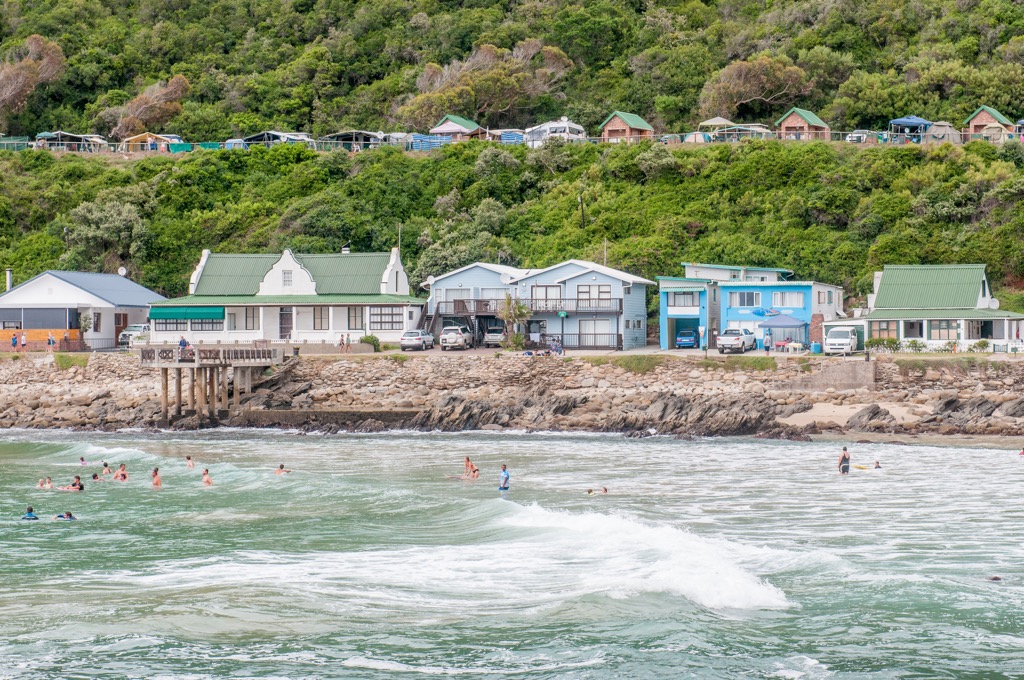
Located just a short drive from George, Victoria Bay is a popular surfing and beach destination with an intimate setting and large swells.
George also serves as an ideal starting point for exploring the Garden Route. Take a scenic drive along this coastal stretch, visiting nearby attractions like Wilderness, Knysna, and Mossel Bay.
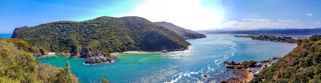
60 km (37 mi) east of George lies Knysna, a popular destination along the Garden Route. The town attracts many visitors for its scenic landscapes and proximity to national forests, famous beaches, and coastal hiking trails.
Located along the Indian Ocean coast, the Knysna Heads are two sandstone cliffs that stand guard over the Knysna Lagoon. There are numerous viewpoints from which to enjoy the lagoon and the ocean. Alternatively, take a boat trip to see marine life near the Heads.
The Knysna Forest is home to enormous trees, gentle streams, undergrowth, and rare birds. Many trails foot and bike trails offer opportunities to encounter wildlife such as bushbuck, baboons, and elephants.
Finally, Knysna is well-known for its oysters. The Knysna Oyster Tour educates visitors on oysters' history and cultivation process, with a chance to sample this delicacy fresh from the sea.