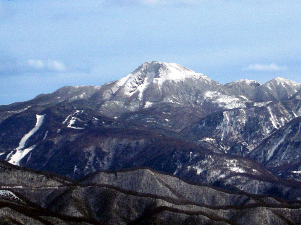
There are 23 named mountains in the Ashio Mountains. The highest and the most prominent is Mt. Nikko-Shirane (2,578m).
This mountain range extends between the southern part of Tochigi prefecture and the northern part of Gunma prefecture, inside the Nikko National Park. Ashio district belongs to the city of Nikkō and is located right on the border of Nikkō and Oku-Nikkō.
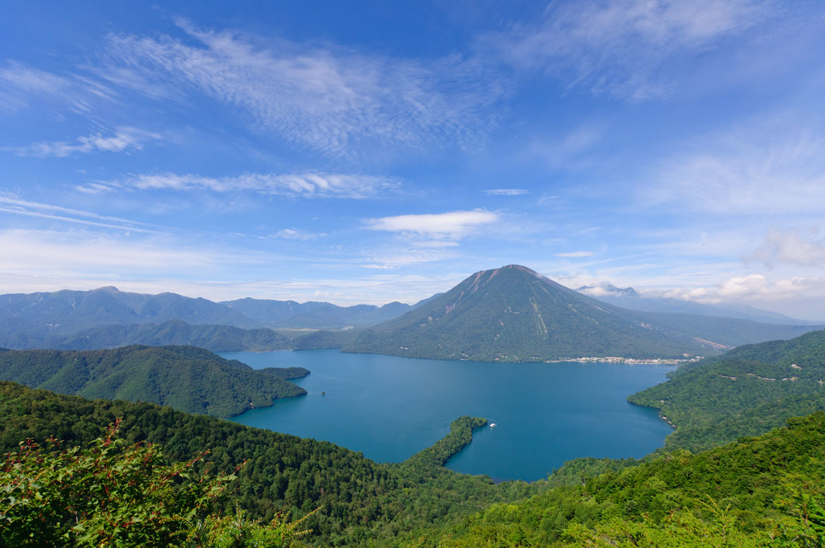
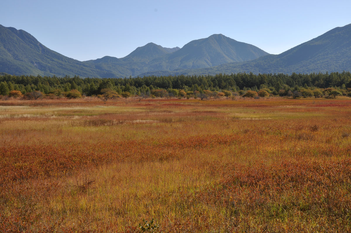
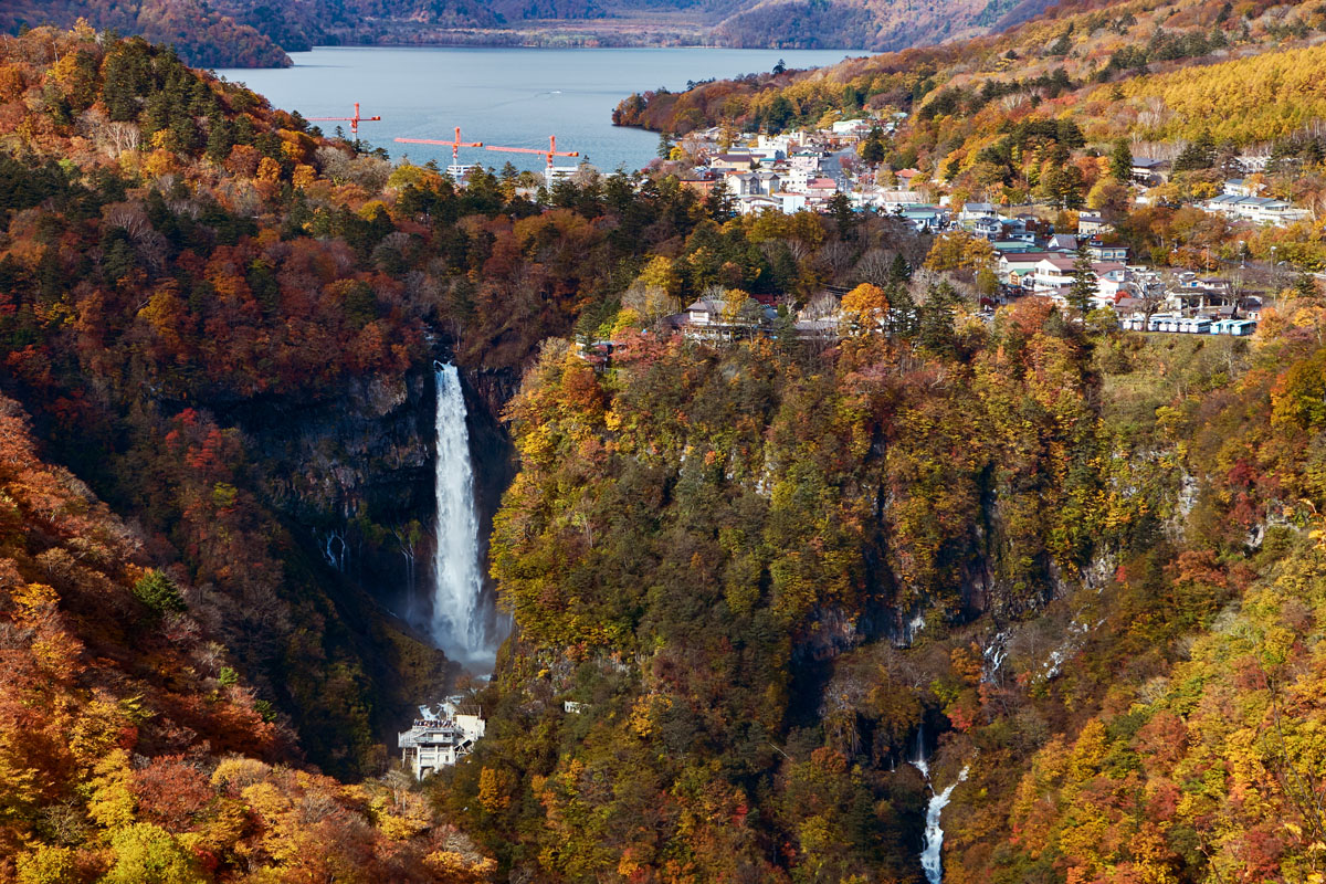
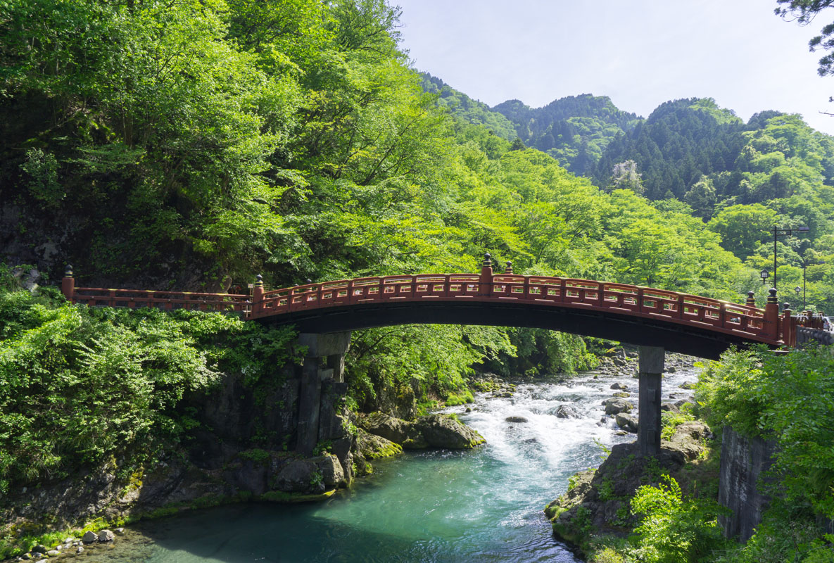
The Daiya River and Lake Chuzenji limit the western side of the range, whereas the Watarase River encircles the southern and eastern borders and the north side is hemmed by the Kanto Plain. On the whole, these peaks are characterized by steep slopes on the west side and gentle slope on the east side, with wide plateaus at their bases. Thanks to ancient volcanic activity, the area is blessed with stunning lakes, beautiful nature reserves, magnificent falls, and valleys coloured in red by splendid autumn leaves. Also, this wonderful scenario hosts several historic world-heritage temples and shrines, like Nikkosan Rinnoji Temple or Chuzenji Temple, visited by thousand tourists and pilgrims every year.

Major Hiking Areas
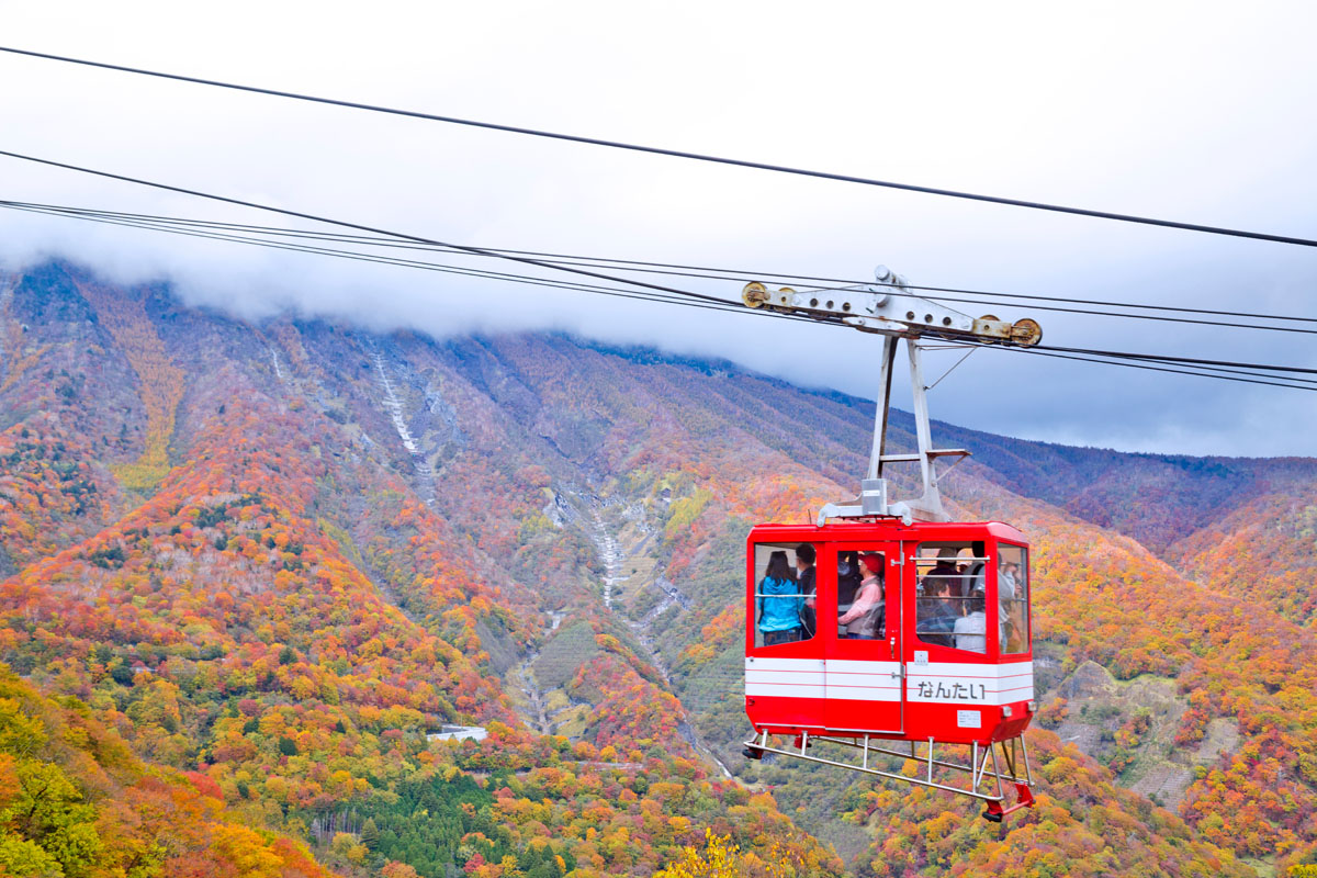
Nikkō Sanzan (日光三山) – Mt. Nantai (男体山 2,486m), Mt. Nyoho (女峰山 2,483m), and Mt. Taro (太郎山2,367m) are the most representative mountains in Nikkō, listed in the 200 Famous Japanese Mountains, an extension of the 100 Famous Japanese Mountains. The first two peaks are called ‘male’ and ‘female’, like many other mountain pairs in Japan. All the trails available are suitable for well-trained hikers who want to face challenging endeavours. Mt. Nantai lies on the northern bank of Lake Chuzenji; one of its trails starts from Nikko Toshogu Shrine and extends for more than 5 km. Since the climbing route is steep and the descent dangerous, especially where rocks are wet, hikers need proper equipment and footwear. It is recommended to hike with a group of people who are familiar with the trail, especially if you are a beginner. The difficulty level is high, and it takes 6-7h to complete the route. There is also a much longer trail on the backside but it isn’t used very much. The route is divided into eight stations, many of which are marked by a square gate. It is also possible to climb it from Futarasan Jinja. Hiking from Shizu Hut on the north side takes about 2h20m. Also, there is a 15km trail that combines a visit to Nikko Futarasan Jinja with Sanbonmatsu Route, close to the Senjogahara Marshlands, for a total of 7h50m walking. Despite its name (‘female’ usually refers to mountains with gentle slopes), the female counterpart is one of the most conical-shaped mountains of the range. On its top, you will find two shrines reminding the holy past of these mountains: Takino Jinja and Nyohosan Jinja. This is also a popular destination for ice climbing. There are 3 long trails on this peak: 1) the Kirifuri Plateau Trail, a long one-day hike feasible in 10h, 2) the Anjadō Trail, a 16km hike characterized by numerous ups and downs 3) the Shizu Nokkoshi Trail, the less dangerous and the longest among the three, extending for 21km. Whatever trail you choose, mind submitting a hiking registration to the local authorities before starting your adventure. The third peak of the triad is Mt. Taro (太郎山2,367m). Because of it being located between Mt. Nantai and Mt. Nyoho, it is considered the son of these two mountains. It lies next to a minor peak called Little Taro, and it is characterized by the presence of lush alpine vegetation. A short climbing route feasible in 3h leads to its top from Kotoku Ranch via Hagatate Plain. It is also possible to choose a 16km long hike feasible in 8h15m, starting from Kotoku Onsen. The descent is quite steep, so you must use ropes in many places, especially because rocks are slippery.
- Ashio Copper Mine is one of the National Historic Sites of Japan. It combines an easy one-day hike to a jump into the Japanese mining history. This mine was active since 1600, but its activity became particularly important during the Meiji Restoration (1868-1912) when mining highly contributed to the fast-paced development of the country, and during the WWII when it was used as a slave labour camp. Now it is part of an open-air museum. Those who like to have a bit of sightseeing may follow the National Route 122 in the southern part of Nikko City and reach the Akagane no Michi Hiking Trail. This route allows you to visit not only the mine but also the Ashio Water Park and the Ashio Dam in 2-3h.
- Mt. Omanago (大真名子山2,375m) has medium-length trails for intermediate-level hikers. The main trailhead is located near Sanbonmatsu, next to a parking lot and a restaurant. This is the same trailhead that leads to Mt. Nantai. Like all the major peaks of the area, Mt. Omanago is part of an ancient network of holy mountains belonging the Shugendō. On its top lies the Mitake Shrine, which contains the Zaogogen, the main object of worship of the sect. Long hikes generally include stops to the other major peaks of the area and present several variations. However, the usual long climb takes a total of about 6h to be completed. The descent includes a stop at a minor peak called Mt. Komanago (小真名子山2,325m) and a traverse through Fujimitoge Pass. The trail presents some difficult spots and risky passages, especially where the ground is softer.
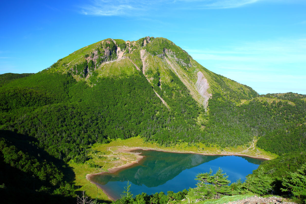
- Mt. Nikko-Shirane belongs to the Nikko volcanic group as well as to the 100 famous Japanese Mountains. Two trails reach the peak. The longer one extends for 10km and it is feasible in 6h starting from Marunuma Kogen. It is possible to skip a part of the trail using a ropeway. This trail joins with the second route at Lake Midagaike but originally starts from Lake Suganuma.
- Mount Sukai (皇海山2,143m) is listed in the 100 famous thanks to its beautiful pristine nature. Mt. Sukai, along with Mt. Poroshiri in Hokkaido, is also considered one of the most difficult 100 famous to access without a car. If you do not have a car, you can reach the trailhead by bus from Numata to Fukuwari Waterfalls, but you will need an MTB to reach the trailhead from the waterfalls. This peak is mainly known for the ancient mountain worship and a bronze sword left on the mountaintop. The hiking trails are mainly two: a 7km trail feasible in 5h, with the trailhead located at Sukai Bridge and a two-days hike, a 23km round trail feasible in13h; this one starts from Koushin Mountain hut and connects Mt. Sukai to Mt. Koshin through Rokurinpan Pass.
- Matsukikeikoku Canyon extends for 3km in the Ashio area and is also called The Grand Canyon of Japan. During the Meiji Period (1868-1912), it was devastated by a forest fire which destroyed the local vegetation, making the terrain infertile and augmenting the risk of turning formerly green pastures into a no man’s land. The fire also gave the valley of Matsukikeikoku Canyon its typical rugged shape. The access via Akagane Water Park was created in parallel to the construction of the Ashio Dam after the damages caused by the fire. At present, it is not accessible by car and it takes about 3h30m exploration of the area in a leisurely round trip.
Mt. Bizendate (備前楯山 1,273m) is a super-popular peak among hikers who choose Ashio Mountains as their destination. All the six major routes may be subject to variations, so it is hiker’s responsibility to plan their route before they start. Hunaishi Route is the most popular, feasible in only 1h by any kind of hikers. Another option consists of starting from Haramuko Station, reaching Mt. Bizendate after traversing the Ginzaidaira Plain, then descending to Mato Station on the opposite side, stopping at Matsuyama in 5h.
Honkuchizawa Route, Gakkokuchi Route, Arikoshi Route, Kotakinosato Route are medium-level hiking trails. They may present some dangerous spots that require proper equipment, like helmets and ropes and are feasible in 2h or more. There is also a difficult trail that traverses Mt. Kinryu.
- Mt. Hangetsu (半月山1,753m) is very driver-friendly, you can reach almost its summit by car. 300m below the summit there is a parking area from which you can enjoy the beautiful view of Mt. Nantai, Lake Chuzenji and the Senjogahara Wetlands. The walk from the parking area to the summit will take up to 1h. If you decide to face the entire ascent you can choose between two different options. Both trails start in Nikko Natural Museum, but one is 6km long and proceeds along the lake banks of Lake Chuzenji, leading to the top in 2h30m, while the other follows an inner path for 4.5km and it is feasible in 3h.
- Senjogahara Plateau Nature Trail follows the Yukawa River during most of its course, which runs between Yumoto Onsen and Ryuzu Waterfalls along the shores of Lake Chuzenji. The hiking trail offers excellent views of the marshland and the surrounding mountains, it is feasible in 3h. Not far from Senjogahara lies Odashirogahara, a smaller but equally idyllic marshland, which deserves a separate visit. There is also a trail network for cross-country skiing on the north side of the Sanbonmatsu parking lot.
Major Cities and Facilities
The Ashio Mountains are part of the city of Nikko, one of the most popular tourist destinations in Japan. The access is convenient from all the major airports of the country, but the area can be reached by bus or train as well. If you are coming from Tokyo, JR East and Tobu Railways are the best options. Being only 2h away from Tokyo, the Ashio Mountains can be a one-day hike destination. It is not only a stone’s throw from the capital, but it is also like a secret box full of natural jewels, a place where people can taste Japanese traditional culture in several different ways. The ancient religious activities are traceable in the numerous World Heritage Shrines and Temples located in the area. The Nikko Toshogu Shrine is the most famous World Heritage in Nikko because it enshrines Tokugawa Ieyasu, the first shogun of the Edo Shogunate. In winter, you may want to enjoy skiing and snowboarding, then indulge in one of the numerous hot springs, like the Ashio Onsen. After a pleasant hike, you may also like to indulge in less adventurous activities, like getting on the Watarase Railway Trolley Train or discover the traditional ceramic art that uses slimes taken out of the Ashio Copper Mine.
Major Cities
- Ashio is quite modest and tranquil now in comparison to what it used to be over its 400-year history. It became very significant from the end of the 19th century to the mid-20th century, when it was the site of major pollution and copper poisoning in the 1880s and the scene of the 1907 miners riots. What Ashio can teach you, is humility and accountability when you are considering long term costs and short term profits.
- Kanuma lies at the eastern foot of the Ashio Highlands and borders Utsunomiya to the east. Kanuma is now a minor industrial centre, producing lumber, furniture, rope, and brooms. The city is called the source of a certain gardening soil called Kanuma-tsuchi. The mountainous western part of the city is a prefectural natural park. Because of the successful lumber business, Kanuma holds a Kanuma Buttuke Autumn Festival every year to remember the hardships of the past and pray for peace and good harvest. Today this festival features traditional music, taiko drumming, and elaborate hand-carved wooden floats, or yatai.
- Nikkō is a plain-looking little mountain settlement in which nestles a pay-to-view miracle of cultural achievement. Nikko showcases some of Japan's most splendid - even gaudy - high culture in a serene and evocative mountain wilderness and offers a unique combination of natural quietude and cultural opulence. Nikko's main sights are Buddhist temples and Shinto shrines, housed often on the same premises. Set in a 424 hectare (1048 acre) domain, these institutions include between them a total of 103 buildings, nine of which are classified as National Treasures and 94 as Important Cultural Properties.