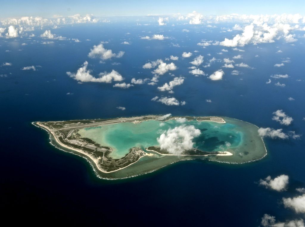
Wake Island (Marshallese: Ānen Kio, lit. 'island of the kio flower'), also known as Wake Atoll, is a coral atoll in the Micronesia subregion of the Pacific Ocean. The atoll is composed of three islets and a reef surrounding a lagoon. The nearest inhabited island is Utirik Atoll in the Marshall Islands, located 592 miles (953 kilometers) to the southeast. The island may have been found by prehistoric Austronesian mariners before its first recorded discovery by Álvaro de Mendaña de Neira in 1568. After this, ships visited the area until it was claimed by the United States in 1899. The island had little development until 1935, when Pan American Airways constructed an airfield and hotel as a waypoint for trans-Pacific flying boats. Japan seized the island at the opening of the Pacific Theatre of World War II in December 1941, and it remained under Japanese occupation until the end of the war in September 1945. After trans-Pacific layovers by Pan American Airways ceased in 1972 due to their use of Boeing 747s, administration was taken over by the United States Air Force, which used the atoll as a processing location for Vietnamese refugees during Operation New Life in 1975. Wake Island, which is claimed by the Marshall Islands, is governed by the United States as an unorganized and unincorporated territory and comprises part of the United States Minor Outlying Islands. It is administered by the United States Air Force under an agreement with the Department of the Interior. The island has no permanent inhabitants, but approximately 100 people live there at any given time. The natural areas of Wake are mix of tropical trees, scrub, and grasses that have adapted to the limited rainfall. Thousands of hermit crabs and rats live on Wake, and in the past there were also feral cats which had been there to help control the rat population, which at one time was estimated at 2 million. The Wake Island rail, a small flightless bird, once lived on the atoll but went extinct during World War II. Many species of seabird also visit Wake, although the thick vegetation has caused most birds to nest on a designated bird sanctuary on Wilkes Island. The submerged and emergent lands at Wake Island comprise a unit of the Pacific Remote Islands Marine National Monument.
Show more
Sun and Moon
Mon
Tue
Wed
Thu
Fri
Sat
Sun
May 2022
Date and time
00:00
06:00
12:00
18:00
Today
--
--
Sunrise
--
Sunset
--
Moonrise
--
Moonset
Phase
🌔 Waxing Gibbous
The perfect light time for beautiful photos:
--
Sunrise
--
Sunset
PeakVisor app
Get the app on your smartphone
New Panorama Tools
Trace location on the map
Measure distances
All the instruments are available in the context menu as well.
We use GPS information embedded into the photo when it is available.
3D mountains overlay
Adjust mountain panorama to perfectly match your photos because recorded by camera photo position might be imprecise.
Move tool
Rotate tool
Zoom
More customization
Choose which peak labels should make into the final photo and what photo title should be.
Next
Photo Location
Satellitte
Flat map
Relief map
Latitude
Longitude
Altitude
OR
Latitude
°'''
Longitude
°'''
Apply
Register Peak
Peak Name
Latitude
Longitude
Altitude
Register
Teleport
PeakVisor
This 3D model of Sagarmatha National Park in Nepal was made using the PeakVisor app topographic data. The mobile app features higher precision models worldwide, more topographic details, and works offline. Download PeakVisor maps today.
Download OBJ model
PeakVisor
The download should start shortly. If you find it useful please consider supporting the PeakVisor app.
PeakVisor for iOS and Android
Be a superhero of outdoor navigation with state-of-the-art 3D maps and mountain identification in the palm of your hand!