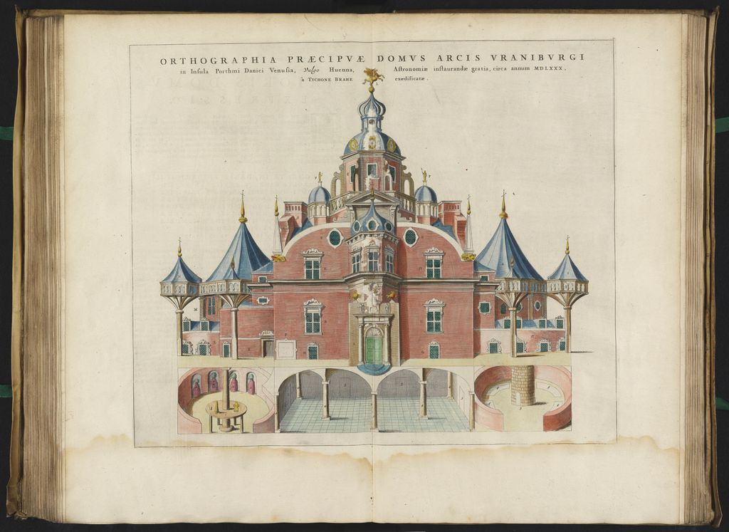
Uraniborg was an astronomical observatory and alchemy laboratory established and operated by the Danish astronomer Tycho Brahe. It was the first custom-built observatory in modern Europe, and the last to be built without a telescope as its primary instrument. Uraniborg was built c. 1576 – c. 1580 on Ven, an island in the Øresund between Zealand and Scania, Sweden, which was part of Denmark at the time. It was expanded with the underground facility Stjerneborg (Swedish: Stjärneborg) on an adjacent site. Brahe also innovated and invented many precision instruments which he used to carry out his studies in the observatory. Research was done in the fields of astronomy, alchemy, and meteorology by Tycho and his assistants. Brahe abandoned Uraniborg and Stjerneborg in 1597 after he fell out of favour with the Danish king, Christian IV of Denmark; Brahe left the country, and the institution was destroyed in 1601 after his death. Ven was later lost to Sweden, and the Rundetårn (Round Tower) in Copenhagen was inaugurated in 1642 as a replacement for Uraniborg's astronomical functions. Restoration of Uraniborg's grounds began in 1985.
Show more
Sun and Moon
Mon
Tue
Wed
Thu
Fri
Sat
Sun
May 2022
Date and time
00:00
06:00
12:00
18:00
Today
--
--
Sunrise
--
Sunset
--
Moonrise
--
Moonset
Phase
🌔 Waxing Gibbous
The perfect light time for beautiful photos:
--
Sunrise
--
Sunset
PeakVisor app
Get the app on your smartphone
New Panorama Tools
Trace location on the map
Measure distances
All the instruments are available in the context menu as well.
We use GPS information embedded into the photo when it is available.
3D mountains overlay
Adjust mountain panorama to perfectly match your photos because recorded by camera photo position might be imprecise.
Move tool
Rotate tool
Zoom
More customization
Choose which peak labels should make into the final photo and what photo title should be.
Next
Photo Location
Satellitte
Flat map
Relief map
Latitude
Longitude
Altitude
OR
Latitude
°'''
Longitude
°'''
Apply
Register Peak
Peak Name
Latitude
Longitude
Altitude
Register
Teleport
PeakVisor
This 3D model of Sagarmatha National Park in Nepal was made using the PeakVisor app topographic data. The mobile app features higher precision models worldwide, more topographic details, and works offline. Download PeakVisor maps today.
Download OBJ model
PeakVisor
The download should start shortly. If you find it useful please consider supporting the PeakVisor app.
PeakVisor for iOS and Android
Be a superhero of outdoor navigation with state-of-the-art 3D maps and mountain identification in the palm of your hand!