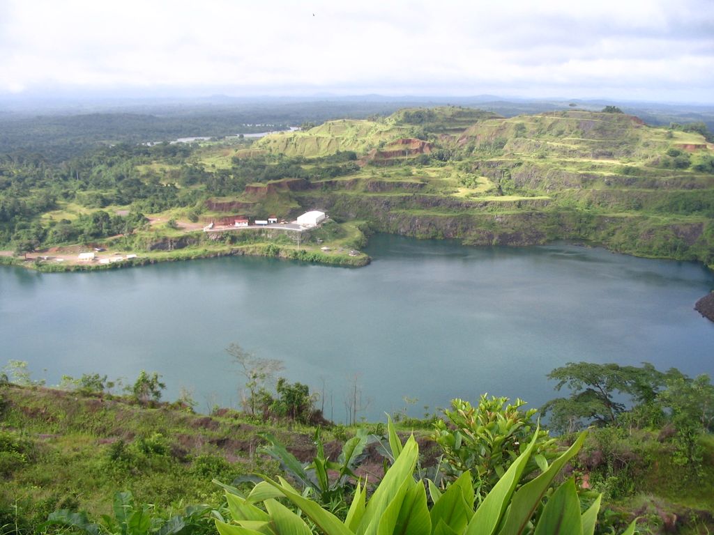
Tubmanburg, also known as Bomi and formerly known as Vaitown, is the capital of Bomi County in Liberia. It lies in the Bomi Hills northwest of Monrovia and was an iron ore and diamond mining centre until it was largely destroyed in the First Liberian Civil War. During the Second Liberian Civil War, it was the headquarters of the Liberians United for Reconciliation and Democracy rebel group. Most residents are members of the Vai tribe. A key attraction is Blue Lake, also known as Bomi Lake. Blue Lake is about 300 feet deep. It is suspended midway between the peaks of the surrounding mountains which, with the sun’s reflection, give the lake its blue hue. The waters spring from a huge pit dug by the Liberia Mining Company, an American-owned company that ceased operations in the country because of the presumed depletion of iron ore in the area. As of the 2008 census, Tubmanburg has an estimated population of 13,144. Of this, 6,555 were male and 6,559 female. The town is populated predominantly by the Gola ethnic group, which hails from Bomi County. The town also has a significant Mandingo and Vai population. During the Ebola virus epidemic in West Africa a treatment center was opened in the town with the assistance of the United States.
Show more
Sun and Moon
Mon
Tue
Wed
Thu
Fri
Sat
Sun
May 2022
Date and time
00:00
06:00
12:00
18:00
Today
--
--
Sunrise
--
Sunset
--
Moonrise
--
Moonset
Phase
🌔 Waxing Gibbous
The perfect light time for beautiful photos:
--
Sunrise
--
Sunset
PeakVisor app
Get the app on your smartphone
New Panorama Tools
Trace location on the map
Measure distances
All the instruments are available in the context menu as well.
We use GPS information embedded into the photo when it is available.
3D mountains overlay
Adjust mountain panorama to perfectly match your photos because recorded by camera photo position might be imprecise.
Move tool
Rotate tool
Zoom
More customization
Choose which peak labels should make into the final photo and what photo title should be.
Next
Photo Location
Satellitte
Flat map
Relief map
Latitude
Longitude
Altitude
OR
Latitude
°'''
Longitude
°'''
Apply
Register Peak
Peak Name
Latitude
Longitude
Altitude
Register
Teleport
PeakVisor
This 3D model of Sagarmatha National Park in Nepal was made using the PeakVisor app topographic data. The mobile app features higher precision models worldwide, more topographic details, and works offline. Download PeakVisor maps today.
Download OBJ model
PeakVisor
The download should start shortly. If you find it useful please consider supporting the PeakVisor app.
PeakVisor for iOS and Android
Be a superhero of outdoor navigation with state-of-the-art 3D maps and mountain identification in the palm of your hand!