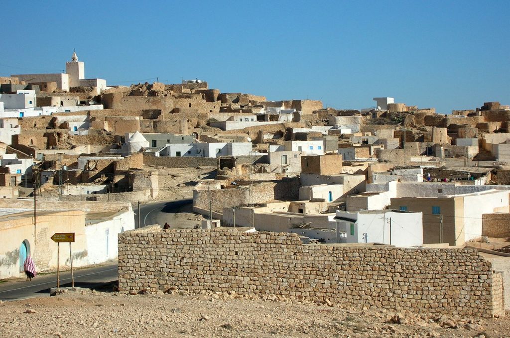
Tamezret or Tamazrat (Berber languages: ⵜⴰⵎⵣⵔⴻⵜ) is a Tunisian Berber village located in the south-east of the country, about ten kilometers from Matmata and forty kilometers southwest of the capital of the governorate of Gabès on which it depends. Ridge village built on the four slopes of one of the highest hills of the Matmata mountains.(480 m altitude). The village is notable for its traditional underground homes, which are carved into the hillside to provide natural insulation against the extreme temperatures of the desert environment. This unique form of architecture reflects the ingenuity of the Berber people and their adaptation to the harsh climate. The narrow, winding streets and intricate stonework of Tamezret further showcase the rich cultural heritage of the region. Visitors to the village can experience the preserved traditions and customs that have been passed down through generations. Additionally, Tamezret serves as a gateway to exploring the stunning desert landscapes and nearby mountains, making it a significant cultural and historical site in Tunisia. Tamezret is not only a testament to ancient architectural practices but also a vibrant community that celebrates its heritage through various cultural events and festivals. The local population, primarily composed of Berbers, continues to practice traditional crafts such as weaving and pottery, which are integral parts of their cultural identity. The village's location on a ridge provides stunning panoramic views of the surrounding desert and mountains, making it a popular spot for tourists seeking both cultural immersion and natural beauty. The local cuisine, heavily influenced by Berber traditions, offers a unique culinary experience with dishes that feature local ingredients and traditional cooking methods. As Tamezret increasingly attracts visitors, efforts are being made to balance tourism with the preservation of its cultural and environmental integrity, ensuring that future generations can continue to enjoy its unique charm.
Show more
Sun and Moon
Mon
Tue
Wed
Thu
Fri
Sat
Sun
May 2022
Date and time
00:00
06:00
12:00
18:00
Today
--
--
Sunrise
--
Sunset
--
Moonrise
--
Moonset
Phase
🌔 Waxing Gibbous
The perfect light time for beautiful photos:
--
Sunrise
--
Sunset
PeakVisor app
Get the app on your smartphone
New Panorama Tools
Trace location on the map
Measure distances
All the instruments are available in the context menu as well.
We use GPS information embedded into the photo when it is available.
3D mountains overlay
Adjust mountain panorama to perfectly match your photos because recorded by camera photo position might be imprecise.
Move tool
Rotate tool
Zoom
More customization
Choose which peak labels should make into the final photo and what photo title should be.
Next
Photo Location
Satellitte
Flat map
Relief map
Latitude
Longitude
Altitude
OR
Latitude
°'''
Longitude
°'''
Apply
Register Peak
Peak Name
Latitude
Longitude
Altitude
Register
Teleport
PeakVisor
This 3D model of Sagarmatha National Park in Nepal was made using the PeakVisor app topographic data. The mobile app features higher precision models worldwide, more topographic details, and works offline. Download PeakVisor maps today.
Download OBJ model
PeakVisor
The download should start shortly. If you find it useful please consider supporting the PeakVisor app.
PeakVisor for iOS and Android
Be a superhero of outdoor navigation with state-of-the-art 3D maps and mountain identification in the palm of your hand!


.jpg)


