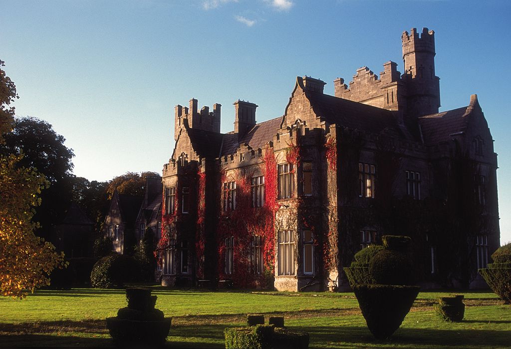
Gurteen de la Poer, or Gurteen le Poer, is an Elizabethan Revival house in County Waterford, Ireland, situated on the south bank of the River Suir, close to Kilsheelan and about 8 km east of Clonmel. The estate belonged to the de la Poers, an Anglo-Norman family whose affiliation with the Catholic Church led to their eventual expulsion from the Protestant English establishment. Edmund, 1st Count de la Poer, 18th Lord le Poer and Curraghmore, a Knight of Malta and Private Chamberlain to Pope Pius X, commenced the building of the present castle in 1863 to replace an earlier house which itself replaced an earlier house. The large baronial house was designed by Samuel Ussher Roberts (1821–1900), great-grandson of the 18th century Waterford architect John Roberts. The design of Castle Gurteen was probably influenced by Scottish architect William Burn, an architect responsible for several Tudor-Baronial mansions in Britain. Construction began 1863 and was completed in 1866. After the completion of Castle Gurteen, Samuel Ussher Roberts also designed Kylemore Castle (now Kylemore Abbey) in County Galway. A number of features used at Gurteen were also used at Kylemore, and the same builder, Thomas Carroll, worked on both castles.
Show more
Sun and Moon
Mon
Tue
Wed
Thu
Fri
Sat
Sun
May 2022
Date and time
00:00
06:00
12:00
18:00
Today
--
--
Sunrise
--
Sunset
--
Moonrise
--
Moonset
Phase
🌔 Waxing Gibbous
The perfect light time for beautiful photos:
--
Sunrise
--
Sunset
PeakVisor app
Get the app on your smartphone
New Panorama Tools
Trace location on the map
Measure distances
All the instruments are available in the context menu as well.
We use GPS information embedded into the photo when it is available.
3D mountains overlay
Adjust mountain panorama to perfectly match your photos because recorded by camera photo position might be imprecise.
Move tool
Rotate tool
Zoom
More customization
Choose which peak labels should make into the final photo and what photo title should be.
Next
Photo Location
Satellitte
Flat map
Relief map
Latitude
Longitude
Altitude
OR
Latitude
°'''
Longitude
°'''
Apply
Register Peak
Peak Name
Latitude
Longitude
Altitude
Register
Teleport
PeakVisor
This 3D model of Sagarmatha National Park in Nepal was made using the PeakVisor app topographic data. The mobile app features higher precision models worldwide, more topographic details, and works offline. Download PeakVisor maps today.
Download OBJ model
PeakVisor
The download should start shortly. If you find it useful please consider supporting the PeakVisor app.
PeakVisor for iOS and Android
Be a superhero of outdoor navigation with state-of-the-art 3D maps and mountain identification in the palm of your hand!