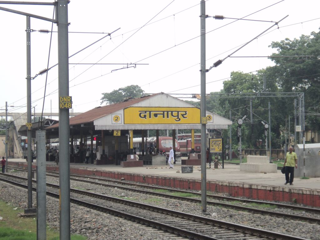
Danapur Railway Station or Danapur Junction, station code DNR, is a large railway station and headquarters of Danapur railway division of East Central Railway. Danapur is connected to metropolitan areas of India by the Delhi–Kolkata main line via Mughalsarai–Patna route. It is in Khagaul city about 6 km from Danapur Cantonment, in Patna district in the Indian state of Bihar. Due to its location on the Howrah–Patna–Mughalsarai main line, many Patna and Barauni-bound express trains coming from Howrah and Sealdah stop here. It lies between Neora to the west and Phulwari Sharif to the east. Another line branches north-eastwards from Danapur and joins Patna–Sonepur line at Patliputra Junction. There are refreshment rooms, vegetarian and non-vegetarian food stall, tea stall, book stall, post and telegraphic office, telephone booth, Government Railway Police (GRP) office and Railway Protection Force (RPF) barracks. Recently Danapur station has been redesigned with street art motifs on its façade, dedicated to the famous mathematician born in Bihar, Aryabhata.
Show more
Sun and Moon
Mon
Tue
Wed
Thu
Fri
Sat
Sun
May 2022
Date and time
00:00
06:00
12:00
18:00
Today
--
--
Sunrise
--
Sunset
--
Moonrise
--
Moonset
Phase
🌔 Waxing Gibbous
The perfect light time for beautiful photos:
--
Sunrise
--
Sunset
PeakVisor app
Get the app on your smartphone
New Panorama Tools
Trace location on the map
Measure distances
All the instruments are available in the context menu as well.
We use GPS information embedded into the photo when it is available.
3D mountains overlay
Adjust mountain panorama to perfectly match your photos because recorded by camera photo position might be imprecise.
Move tool
Rotate tool
Zoom
More customization
Choose which peak labels should make into the final photo and what photo title should be.
Next
Photo Location
Satellitte
Flat map
Relief map
Latitude
Longitude
Altitude
OR
Latitude
°'''
Longitude
°'''
Apply
Register Peak
Peak Name
Latitude
Longitude
Altitude
Register
Teleport
PeakVisor
This 3D model of Sagarmatha National Park in Nepal was made using the PeakVisor app topographic data. The mobile app features higher precision models worldwide, more topographic details, and works offline. Download PeakVisor maps today.
Download OBJ model
PeakVisor
The download should start shortly. If you find it useful please consider supporting the PeakVisor app.
PeakVisor for iOS and Android
Be a superhero of outdoor navigation with state-of-the-art 3D maps and mountain identification in the palm of your hand!