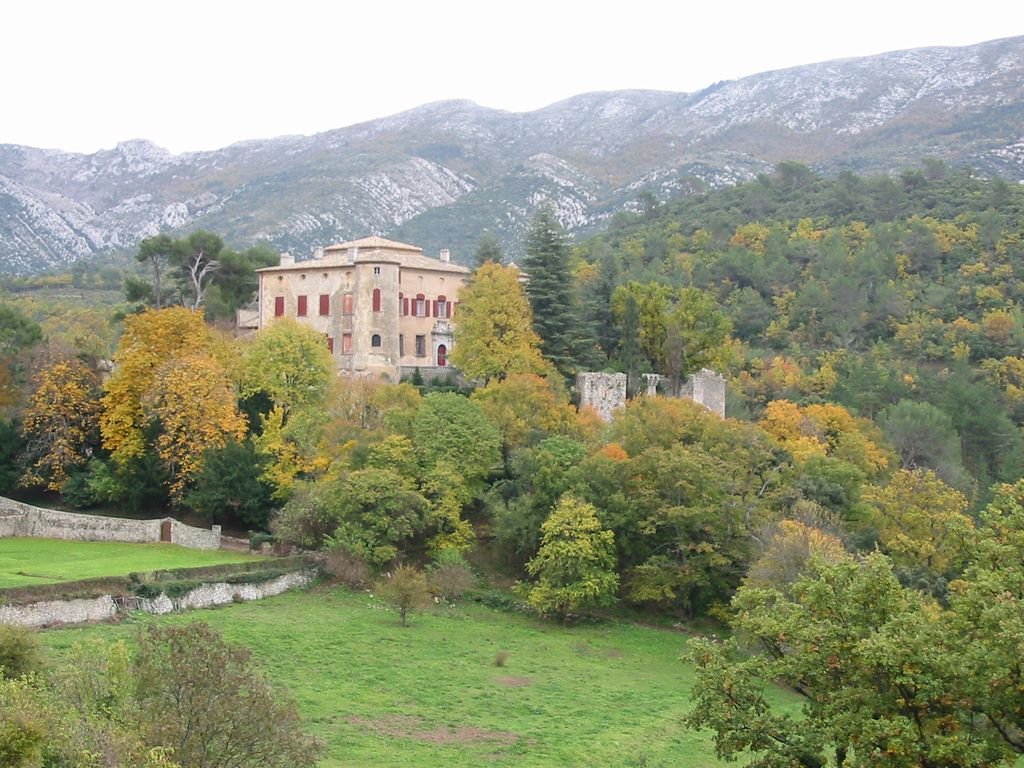
The Château of Vauvenargues (French: Château de Vauvenargues) is a fortified bastide in the village of Vauvenargues, situated to the north of Montagne Sainte-Victoire, just outside the town of Aix-en-Provence in the south of France. Built on a site occupied since Roman times, it became a seat of the Counts of Provence in the Middle Ages, passing to the Archbishops of Aix in the thirteenth century. It acquired its present architectural form in the seventeenth century as the family home of the marquis de Vauvenargues. After the French Revolution it was sold to the Isoard family, who despite their humble origins eventually installed their coat of arms in the chateau. Nineteenth century additions include a ceramic maiolica profile in the Italian Renaissance style of René of Anjou, one of the former owners, and a small shrine containing the relics of St Severin. In 1929 the chateau was officially listed as a historic monument. In 1943 it was sold by the Isoard family to three industrialists from Marseille, who stripped it of its furnishings and mural decoration, some of which still survives in the Château of La Barben. In 1947 it became a vacation centre for a maritime welfare institution. It was acquired in September 1958 by the exiled Spanish artist Pablo Picasso, seeking a more isolated working place than his previous home, "La Californie" in Cannes. He occupied and remodeled the chateau from 1959 until 1962, after which he moved to Mougins. He and his wife Jacqueline are buried in the grounds of the chateau of Vauvenargues, which is still the private property of the Picasso family. Their tomb is a grassy mound surmounted by La Dame à l'offrande (1933) (English: Woman with a Vase), a monumental sculpture that previously guarded the entrance of the Spanish pavilion at the International Exhibition in Paris in 1937.
Show more
Sun and Moon
Mon
Tue
Wed
Thu
Fri
Sat
Sun
May 2022
Date and time
00:00
06:00
12:00
18:00
Today
--
--
Sunrise
--
Sunset
--
Moonrise
--
Moonset
Phase
🌔 Waxing Gibbous
The perfect light time for beautiful photos:
--
Sunrise
--
Sunset
PeakVisor app
Get the app on your smartphone
New Panorama Tools
Trace location on the map
Measure distances
All the instruments are available in the context menu as well.
We use GPS information embedded into the photo when it is available.
3D mountains overlay
Adjust mountain panorama to perfectly match your photos because recorded by camera photo position might be imprecise.
Move tool
Rotate tool
Zoom
More customization
Choose which peak labels should make into the final photo and what photo title should be.
Next
Photo Location
Satellitte
Flat map
Relief map
Latitude
Longitude
Altitude
OR
Latitude
°'''
Longitude
°'''
Apply
Register Peak
Peak Name
Latitude
Longitude
Altitude
Register
Teleport
PeakVisor
This 3D model of Sagarmatha National Park in Nepal was made using the PeakVisor app topographic data. The mobile app features higher precision models worldwide, more topographic details, and works offline. Download PeakVisor maps today.
Download OBJ model
PeakVisor
The download should start shortly. If you find it useful please consider supporting the PeakVisor app.
PeakVisor for iOS and Android
Be a superhero of outdoor navigation with state-of-the-art 3D maps and mountain identification in the palm of your hand!