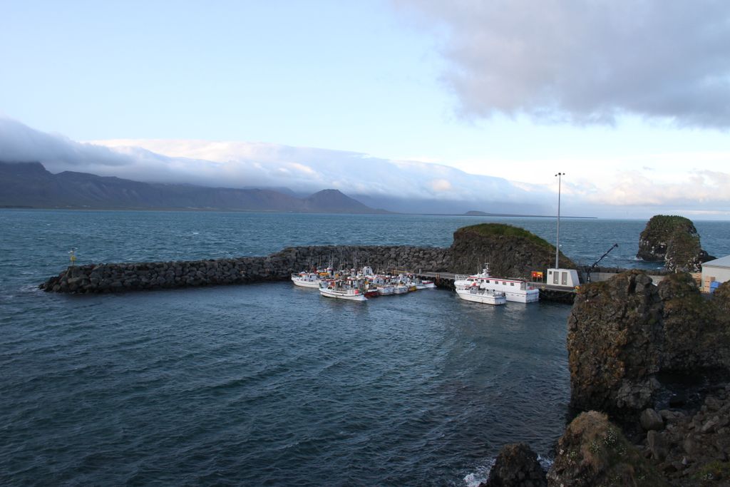
Arnarstapi (Icelandic pronunciation: [ˈa(r)tnarˌstaːpɪ]) or Stapi is a small fishing village at the foot of Mt. Stapafell [ˈstaːpaˌfɛtl̥] between Hellnar village and Breiðavík [ˈpreiːðaˌviːk] farms on the southern side of Snæfellsnes, Iceland. Placenames in the vicinity of Arnarstapi and nearby Hellnar village are inspired by Bárðar saga Snæfellsáss, an Icelandic saga relating the story of Bárður, a half human and half ogre. Arnarstapi was a natural site for landings and harbor for small vessels, and therefore ideal for a shipping port. In the olden days, Arnarstapi was thus from very early on, a busy fishing port and commercial centre servicing the West coast area under the Danish crown and a merchant monopoly of Denmark was in effect from 1565. From then on and through the 17th and 18th century, agents of the Danish crown had custodial power over Arnarstapi and commercial rights by royal appointment over nearby lands, formerly owned by Helgafell monastery and monopoly of all trade in the area. Several old houses from that time, each with its own unique history, can be seen at Arnarstapi, the old Amtmannshús (The Danish Prefect's Residence (1774–1787) having a history of its own, it having been moved in 1849 to nearby Vogur á Mýrum [ˈvouː(ɣ)ʏr auː ˈmiːrʏm], where it stayed until 1983, when it was moved back again to Arnarstapi in 1985 and declared a historical site in 1990. There resided amongst other notables, Danish Prefect Bjarni Thorsteinsson (1821–1849), whose son was renowned poet and writer Steingrímur Thorsteinsson. Today Arnarstapi is still a somewhat busy harbor during the summer months serving private fishing and recreational vessels as well with its maintained docks that were renewed in 2002. Being a popular destination of tourists in summer, Arnarstapi is today a thriving centre for local tourism activities where there is a variety of natural and culinary attractions as well and a cluster of second homes are located in and around the village. There is much beauty to be found in nearby attractions, and an old horse trail past Neðstavatn [ˈnɛðstaˌvahtn̥] is now a popular hiking trail across the lava and along the beach between Arnarstapi and Hellnar. This walk is about one hour. The lava field is called Hellnahraun, and its coast where at its westernmost edge can be found the ancient small village of Hellnar is a natural preserve. Along the coast there are some unique rock formations to be seen. There the waves of the ocean play along with the sun and the daylight to produce a natural show of which the most spectacular can be experienced at the cliff Gatklettur [ˈkatˌkʰlɛhtʏr̥], and the rifts Hundagjá [ˈhʏntaˌcauː], Miðgjá [ˈmɪðˌcauː] and Músagjá [ˈmuːsaˌcauː]. Near Arnarstapi you will also find many other interesting natural wonders like Rauðfeldsgjá, Dritvík [ˈtrɪtˌviːk], Bjarnarfoss [ˈpja(r)tnarˌfɔsː] and Lóndrangar.
Show more
Sun and Moon
Mon
Tue
Wed
Thu
Fri
Sat
Sun
May 2022
Date and time
00:00
06:00
12:00
18:00
Today
--
--
Sunrise
--
Sunset
--
Moonrise
--
Moonset
Phase
🌔 Waxing Gibbous
The perfect light time for beautiful photos:
--
Sunrise
--
Sunset
PeakVisor app
Get the app on your smartphone
New Panorama Tools
Trace location on the map
Measure distances
All the instruments are available in the context menu as well.
We use GPS information embedded into the photo when it is available.
3D mountains overlay
Adjust mountain panorama to perfectly match your photos because recorded by camera photo position might be imprecise.
Move tool
Rotate tool
Zoom
More customization
Choose which peak labels should make into the final photo and what photo title should be.
Next
Photo Location
Satellitte
Flat map
Relief map
Latitude
Longitude
Altitude
OR
Latitude
°'''
Longitude
°'''
Apply
Register Peak
Peak Name
Latitude
Longitude
Altitude
Register
Teleport
PeakVisor
This 3D model of Sagarmatha National Park in Nepal was made using the PeakVisor app topographic data. The mobile app features higher precision models worldwide, more topographic details, and works offline. Download PeakVisor maps today.
Download OBJ model
PeakVisor
The download should start shortly. If you find it useful please consider supporting the PeakVisor app.
PeakVisor for iOS and Android
Be a superhero of outdoor navigation with state-of-the-art 3D maps and mountain identification in the palm of your hand!


.jpg)
.jpg)