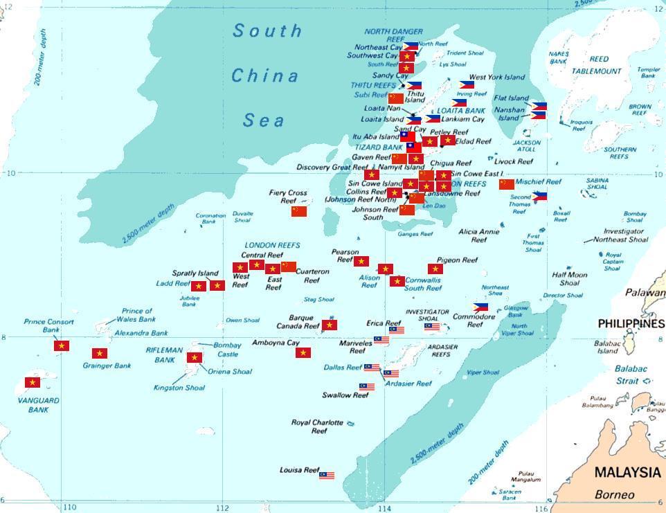
Amboyna Cay, also known as Vietnamese: Đảo An Bang; Malay: Pulau Amboyna Kecil; Datu Kalantiaw Island (Filipino: Pulo ng Datu Kalantiaw, lit. 'Island of Datu Kalantiaw'); Mandarin Chinese: 安波沙洲; pinyin: Ānbō Shāzhōu, and other names, is an island of the Spratly Islands group in the South China Sea located just outside (SW) of the southwest of Dangerous Ground. It is SW of Barque Canada Reef, south of the London Reefs, and NW of Swallow Reef. With an area of 1.6 hectares (4.0 acres), it is the thirteenth largest naturally occurring Spratly island and the sixth largest amongst those occupied by Vietnam. The island has two parts: the eastern part consists of sand and coral, and the west part is covered with guano. It has a fringing reef. An obelisk, about 2.7 metres (8 ft 10 in) high, stands on the SW corner. There is little vegetation. It is described by some as heavily fortified. A lighthouse has been operational on the island since May 1995. The island is also claimed by China, Malaysia, the Philippines and Taiwan.
Show more
Sun and Moon
Mon
Tue
Wed
Thu
Fri
Sat
Sun
May 2022
Date and time
00:00
06:00
12:00
18:00
Today
--
--
Sunrise
--
Sunset
--
Moonrise
--
Moonset
Phase
🌔 Waxing Gibbous
The perfect light time for beautiful photos:
--
Sunrise
--
Sunset
PeakVisor app
Get the app on your smartphone
New Panorama Tools
Trace location on the map
Measure distances
All the instruments are available in the context menu as well.
We use GPS information embedded into the photo when it is available.
3D mountains overlay
Adjust mountain panorama to perfectly match your photos because recorded by camera photo position might be imprecise.
Move tool
Rotate tool
Zoom
More customization
Choose which peak labels should make into the final photo and what photo title should be.
Next
Photo Location
Satellitte
Flat map
Relief map
Latitude
Longitude
Altitude
OR
Latitude
°'''
Longitude
°'''
Apply
Register Peak
Peak Name
Latitude
Longitude
Altitude
Register
Teleport
PeakVisor
This 3D model of Sagarmatha National Park in Nepal was made using the PeakVisor app topographic data. The mobile app features higher precision models worldwide, more topographic details, and works offline. Download PeakVisor maps today.
Download OBJ model
PeakVisor
The download should start shortly. If you find it useful please consider supporting the PeakVisor app.
PeakVisor for iOS and Android
Be a superhero of outdoor navigation with state-of-the-art 3D maps and mountain identification in the palm of your hand!